Muratpaşa
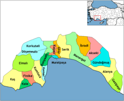
Muratpaşa is a district in Antalya, Turkey. The district has a coastline of 20 km (12 mi). Mediterranean Sea is in south of district.
Muratpaşa | |
|---|---|
 Muratpaşa | |
| Coordinates: 36°52′57″N 30°46′09″E | |
| Country | Turkey |
| Province | Antalya |
| Government | |
| • Mayor | Ümit Uysal |
| • Kaymakam | Fatih Kocabaş |
| Area | |
| • | 88.84 km2 (34.30 sq mi) |
| Elevation | 39 m (128 ft) |
| Population (2013)[2] | |
| • Urban | 453,255 |
| • District | 442,663 |
| • District density | 5,000/km2 (13,000/sq mi) |
| Website | www.muratpasa.bel.tr/ |
History

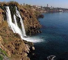
Düden Waterfall in Muratpaşa, Antalya
Kaleiçi (Old Town) in Muratpaşa, Antalya
Modern day district of Muratpaşa is home to Kaleiçi, the historic center founded by Attalus II, King of Pergamon around 150 BC. Since then, the district has been under Lydian,Roman,Persian Byzantine, Seljuk,Kingdom of Cyprus,Beylik of Teke, Ottoman,Italian Occupation,and Turkish Republic rule.[3]
gollark: Probably not.
gollark: You get cooperatives and stuff which try and run communes within capitalism, but they go ”full capitalist“ eventually.
gollark: As I've said previously, the graph of technology level to infrastructure required to keep that going is probably quite inverted-U-shaped, and commune stuff can probably only work at the lower ends.
gollark: ... impractical.
gollark: There are also people with *too much* food, which is a less bad problem than too little.
See also
- Muratpaşa Belediyesi Spor Kulübü, the local sports club
References
- "Area of regions (including lakes), km²". Regional Statistics Database. Turkish Statistical Institute. 2002. Retrieved 2013-03-05.
- "Population of province/district centers and towns/villages by districts - 2012". Address Based Population Registration System (ABPRS) Database. Turkish Statistical Institute. Retrieved 2013-02-27.
- "Antalya Muratpaşa Belediyesi". muratpasa-bld.gov.tr. Retrieved 2018-05-13.
This article is issued from Wikipedia. The text is licensed under Creative Commons - Attribution - Sharealike. Additional terms may apply for the media files.
