Munchon
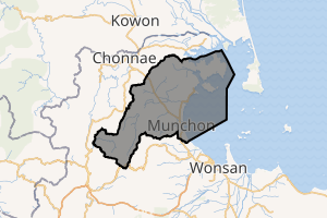
Munch'ŏn (Korean pronunciation: [mun.tsʰʌn]) is a North Korean city located in Kangwŏn Province. It lies on the coast of the Sea of Japan (East Sea of Korea) and borders Wonsan.
Munch'ŏn 문천시 | |
|---|---|
| Korean transcription(s) | |
| • Chosŏn'gŭl | 문천시 |
| • Hancha | 文川市 |
| • McCune-Reischauer | Munch'ŏn si |
| • Revised Romanization | Muncheon-si |
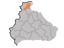 Map of Kangwon showing the location of Munch'ŏn | |
| |
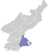
 Munch'ŏn Location within North Korea | |
| Coordinates: 39.259°N 127.356°E | |
| Country | North Korea |
| Province | Kangwon Province |
| Administrative divisions | 16 tong, 14 ri |
| Population (2008) | |
| • Total | 122,934 |
| Time zone | UTC+9 (Pyongyang Time) |
| Climate | Dwa |
Geography
Munch'ŏn sits on Yŏnghŭng Bay, a bay of the Sea of Japan, on lowland seacoast terrain. The Masingryŏng Mountain Range is to the southwest. The Sokko Mountain Range and Ch'ŏllyŏng Mountain Range are also located here, and Kulttuk Peak is the highest mountain in the region. The main river is the Namch'ŏn River.
Climate
Munch'ŏn has a humid continental climate (Köppen climate classification: Dwa).
| Climate data for Munch'ŏn | |||||||||||||
|---|---|---|---|---|---|---|---|---|---|---|---|---|---|
| Month | Jan | Feb | Mar | Apr | May | Jun | Jul | Aug | Sep | Oct | Nov | Dec | Year |
| Average high °C (°F) | 1.3 (34.3) |
2.4 (36.3) |
7.6 (45.7) |
15.9 (60.6) |
20.9 (69.6) |
24.3 (75.7) |
27.2 (81.0) |
27.9 (82.2) |
24.0 (75.2) |
18.9 (66.0) |
10.4 (50.7) |
3.1 (37.6) |
15.3 (59.6) |
| Daily mean °C (°F) | −3.9 (25.0) |
−2.4 (27.7) |
2.8 (37.0) |
10.1 (50.2) |
15.3 (59.5) |
19.6 (67.3) |
23.3 (73.9) |
23.8 (74.8) |
19.0 (66.2) |
13.2 (55.8) |
5.6 (42.1) |
−1.3 (29.7) |
10.4 (50.8) |
| Average low °C (°F) | −9.0 (15.8) |
−7.2 (19.0) |
−1.9 (28.6) |
4.4 (39.9) |
9.8 (49.6) |
15.0 (59.0) |
19.4 (66.9) |
19.8 (67.6) |
14.1 (57.4) |
7.5 (45.5) |
0.9 (33.6) |
−5.7 (21.7) |
5.6 (42.1) |
| Average precipitation mm (inches) | 27 (1.1) |
28 (1.1) |
48 (1.9) |
64 (2.5) |
75 (3.0) |
125 (4.9) |
348 (13.7) |
365 (14.4) |
235 (9.3) |
57 (2.2) |
54 (2.1) |
24 (0.9) |
1,450 (57.1) |
| Source: Climate-Data.org [1] | |||||||||||||
Administrative divisions
Munch'ŏn is divided into 16 tong and 14 ri:
|
|
Economy
Transportation
Munch'ŏn-si is served by the Kangwŏn Line of the Korean State Railway, with stations at Koam-dong, Okp'yŏng-dong and Munch'ŏn-dong.
gollark: You can't get addicted to lead.
gollark: I mean...
gollark: Solution: make all guns from radioactive materials so people don't want to have them.
gollark: It *isn't* in less gun-y countries like this one.
gollark: I lean somewhat libertarian, so I'd say "guns to anyone who is demonstrated to be reasonably sane and able to handle guns safely and is probably not a criminal".
References
- "Climate: Munch'ŏn". Climate-Data.org. Retrieved July 27, 2018.
Further reading
- Dormels, Rainer. North Korea's Cities: Industrial facilities, internal structures and typification. Jimoondang, 2014. ISBN 978-89-6297-167-5
External links
- (in Korean) In Korean language online encyclopedias:
- Korea Tourist Map (English, Korean, Japanese, Chinese)
- City profile of Munchon
This article is issued from Wikipedia. The text is licensed under Creative Commons - Attribution - Sharealike. Additional terms may apply for the media files.