Ichon County
Ich'ŏn County is a kun, or county, in northern Kangwŏn province, North Korea. The terrain is predominantly high and mountainous; the highest point is Myongidoksan, 1,585 meters above sea level. The county's borders run along the Masingryong and Ryongam ranges. The chief stream is the Rimjin River.
Ich'ŏn County 이천군 | |
|---|---|
| Korean transcription(s) | |
| • Chosŏn'gŭl | 이천군 |
| • Hancha | 伊川郡 |
| • McCune-Reischauer | Ich'ŏn-gun |
| • Revised Romanization | Icheon-gun |
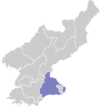
 Map of Kangwon showing the location of Ichon | |
| Country | North Korea |
| Province | Kangwŏn Province |
| Administrative divisions | 1 ŭp, 22 ri |
Administrative divisions
Ich'ŏn county is divided into 1 ŭp (town) and 22 ri (villages):
|
|
Economy
Agriculture
Agriculture is limited to the low-lying regions. Sericulture (silk farming) is also practised. Due to the abundant woods, lumbering is also an important industry.
Transport
Ich'ŏn is served by roads, and by the Ch'ŏngnyŏn Ich'ŏn line of the Korean State Railway.
gollark: Anyway, acceptable pronouns for me:`the supreme overlord of all, master of all space and time, destroyer of worlds, devourer of souls/the supreme overlord of all, master of all space and time, destroyer of worlds, devourer of souls/the supreme overlord of all, master of all space and time, destroyer of worlds, devourer of souls's/the supreme overlord of all, master of all space and time, destroyer of worlds, devourer of souls's/the supreme overlord of all, master of all space and time, destroyer of worlds, devourer of souls``ţͦͧh́͐̍e̎̇͒y̸̯̱/t̰̺͡h̐ͤ͊ē̺̓m̘̹̑/t̄͋ͫ҉h̏̌̔e͙̭̩i̬ͅͅr̄̓ͨ҉̫͎͙/tͬͤ̆h̅͑̿ē̴̏ị̍̅r̷͎s̽͛̌/t̽͛̈hͪ̄ͭė̔̂m͑̊ͪś̀̚ĕͯ̎ḻ̡̤f̃ͧ̾҉͉̗͔``hͫ́̄eͬ̅̚/h̓ͭ̈i̇̊̚m̏͂͗҉͉̜̖/ḣ̅ͧi̍͛̇s̽̎͆/h̔̒̓î̀̓s̉͋̅/h̃ͩͩ҉̗͎̯iͦͣ̈mͧ͒̂s̃̽ͦȇ̈ͩlͨͩ̀fͮ̿͒``No pronouns. (Do not refer to me in any way.)`
gollark: You are but a mere imitation of helloboi, and not a good one.
gollark: Except me, check my pronouny account for up-to-date information.
gollark: everyone is theyMWAHAHAHA
gollark: "Current target: Block #222 (shorthash 000000002e84, work 100000)", as I like to say.
External links
- (in Korean) In Korean language online encyclopedias:
This article is issued from Wikipedia. The text is licensed under Creative Commons - Attribution - Sharealike. Additional terms may apply for the media files.