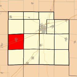
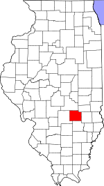
Mound Township, Effingham County, Illinois
Mound Township is one of fifteen townships in Effingham County, Illinois, USA. As of the 2010 census, its population was 3,648 and it contained 1,494 housing units.[2]
Mound Township | |
|---|---|
 Location in Effingham County | |
 Effingham County's location in Illinois | |
| Coordinates: 39°03′N 88°45′W | |
| Country | United States |
| State | Illinois |
| County | Effingham |
| Established | November 6, 1860 |
| Area | |
| • Total | 37.1 sq mi (96 km2) |
| • Land | 36.97 sq mi (95.8 km2) |
| • Water | 0.13 sq mi (0.3 km2) 0.35% |
| Elevation | 633 ft (193 m) |
| Population (2010) | |
| • Estimate (2016)[1] | 3,611 |
| • Density | 98.7/sq mi (38.1/km2) |
| Time zone | UTC-6 (CST) |
| • Summer (DST) | UTC-5 (CDT) |
| ZIP codes | 62411, 62458 |
| FIPS code | 17-049-50725 |
Geography
According to the 2010 census, the township (T7N R4E) has a total area of 37.1 square miles (96 km2), of which 36.97 square miles (95.8 km2) (or 99.65%) is land and 0.13 square miles (0.34 km2) (or 0.35%) is water.[2]
Cities, towns, villages
Extinct towns
- East Meadows
- Southmore Heights
Cemeteries
The township contains these ten cemeteries: Bethlehem, Drysdale, German Methodist, Immanuel Lutheran, McCoy, Newman, Saint Clare Catholic, Union, Union and Zion Lutheran.
Major highways


School districts
- Altamont Community Unit School District 10
Political districts
- Illinois' 19th congressional district
- State House District 102
- State House District 109
- State Senate District 51
- State Senate District 55
gollark: Also it does nothing right now except say "setup done".
gollark: You need moderator-level perms to do it.
gollark: --telephone setup
gollark: Oh, great, it is.
gollark: ... is it j8st *not reminding*, now?
References
- "Mound Township, Effingham County, Illinois". Geographic Names Information System. United States Geological Survey. Retrieved 2010-01-16.
- United States Census Bureau 2007 TIGER/Line Shapefiles
- United States National Atlas
- "Population and Housing Unit Estimates". Retrieved June 9, 2017.
- "Population, Housing Units, Area, and Density: 2010 - County -- County Subdivision and Place -- 2010 Census Summary File 1". United States Census. Archived from the original on 2020-02-12. Retrieved 2013-05-28.
- "Census of Population and Housing". Census.gov. Retrieved June 4, 2016.
External links
This article is issued from Wikipedia. The text is licensed under Creative Commons - Attribution - Sharealike. Additional terms may apply for the media files.