Banner Township, Effingham County, Illinois
Banner Township is one of fifteen townships in Effingham County, Illinois, USA. As of the 2010 census, its population was 456 and it contained 199 housing units.[2]
Banner Township | |
|---|---|
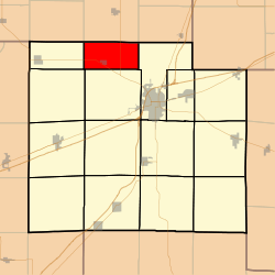 Location in Effingham County | |
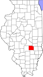 Effingham County's location in Illinois | |
| Coordinates: 39°12′N 88°38′W | |
| Country | United States |
| State | Illinois |
| County | Effingham |
| Area | |
| • Total | 18.03 sq mi (46.7 km2) |
| • Land | 18.03 sq mi (46.7 km2) |
| • Water | 0 sq mi (0 km2) 0% |
| Elevation | 640 ft (195 m) |
| Population (2010) | |
| • Estimate (2016)[1] | 452 |
| • Density | 25.3/sq mi (9.8/km2) |
| Time zone | UTC-6 (CST) |
| • Summer (DST) | UTC-5 (CDT) |
| ZIP codes | 62401, 62461 |
| FIPS code | 17-049-03558 |
Geography
According to the 2010 census, the township (S½ T9N R5E) has a total area of 18.03 square miles (46.7 km2), all land.[2]
Cities, towns, villages
Cemeteries
The township contains these four cemeteries: Rentfrow, Saint Marys, Shumway and Trinity Lutheran.
Major highways
School districts
- Beecher City Community Unit School District 20
- Effingham Community Unit School District 40
- Stewardson-Strasburg Community Unit District 5a
- Teutopolis Community Unit School District 50
Political districts
- Illinois' 19th congressional district
- State House District 109
- State Senate District 55
gollark: https://images-ext-2.discordapp.net/external/NU7NmV5LVUclgsc5OF8v3p6GPa-3s_6UHIz0p7Py2XM/https/media.discordapp.net/attachments/733347369847881838/907834452842020864/unknown.png
gollark: https://media.discordapp.net/attachments/348702212110680064/955090116978810960/IMG_4416.png
gollark: "Bolt" can mean "run away fast".
gollark: Or maybe some kind of hybrid.
gollark: Solution: flywheels, or just do not stop the car ever.
References
- "Banner Township, Effingham County, Illinois". Geographic Names Information System. United States Geological Survey. Retrieved 2010-01-10.
- United States Census Bureau 2007 TIGER/Line Shapefiles
- United States National Atlas
- "Population and Housing Unit Estimates". Retrieved June 9, 2017.
- "Population, Housing Units, Area, and Density: 2010 - County -- County Subdivision and Place -- 2010 Census Summary File 1". United States Census. Archived from the original on 2020-02-12. Retrieved 2013-05-28.
- "Census of Population and Housing". Census.gov. Retrieved June 4, 2016.
External links
Places adjacent to Banner Township, Effingham County, Illinois | |
|---|---|
Municipalities and communities of Effingham County, Illinois, United States | ||
|---|---|---|
| Cities | Map of Illinois highlighting Effingham County | |
| Town | ||
| Villages | ||
| Townships | ||
| Unincorporated communities | ||
| Footnotes | ‡This populated place also has portions in an adjacent county or counties | |
This article is issued from Wikipedia. The text is licensed under Creative Commons - Attribution - Sharealike. Additional terms may apply for the media files.