Mongarlowe, New South Wales
Mongarlowe is a village in the Southern Tablelands of New South Wales, Australia in Queanbeyan-Palerang Regional Council.[2][3] It was formerly known as Little River.
| Mongarlowe New South Wales | |||||||||||||||
|---|---|---|---|---|---|---|---|---|---|---|---|---|---|---|---|
 | |||||||||||||||
Mongarlowe Location in New South Wales | |||||||||||||||
| Coordinates | 35.422°S 149.939°E | ||||||||||||||
| Population | 117 (2016 census)[1] | ||||||||||||||
| Postcode(s) | 2622 | ||||||||||||||
| Location | 13 km (8 mi) from Braidwood | ||||||||||||||
| LGA(s) | Queanbeyan-Palerang Regional Council | ||||||||||||||
| Region | Southern Tablelands | ||||||||||||||
| County | St Vincent | ||||||||||||||
| Parish | Budawang | ||||||||||||||
| State electorate(s) | Monaro | ||||||||||||||
| Federal Division(s) | Eden-Monaro | ||||||||||||||
| |||||||||||||||
Location and features
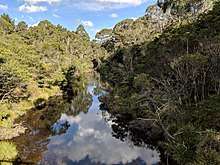
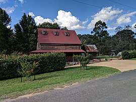
It is situated on the Mongarlowe River and about 13 km east of Braidwood. At the 2016 census, the village and the surrounding area had a population of 117. Several buildings have survived from the 19th century, when it was much larger.
History
Mongarlowe was a substantial mining settlement during the mid-19th century due to the New South Wales gold rush. It was called Monga until 1891.[4] It had a public school from 1863 to 1963.[5]
Another population boom followed during the Depression when many returned to distill eucalyptus oil and search again for gold.
There was a proposal for a 98 lot subdivision in proximity to the village which was cancelled in 2008 under pressure from concerned residents.
Heritage listings
Mongarlowe has a number of heritage-listed sites, including:
- Half Moon Road: Half Moon Farm House[6]
References
- Australian Bureau of Statistics (27 June 2017). "Mongarlowe (state suburb)". 2016 Census QuickStats. Retrieved 29 June 2017.

- "Mongarlowe". Geographical Names Register (GNR) of NSW. Geographical Names Board of New South Wales. Retrieved 1 November 2017.
- "Mongarlowe". OpenStreetMap. Retrieved 2 November 2017.
- Information sign at Mongarlowe
- "Mongarlowe public school in the School history database search". New South Wales Department of Education. Retrieved 15 March 2018.
- "Half Moon Farm House". New South Wales State Heritage Register. Office of Environment and Heritage. H00288. Retrieved 18 May 2018.
| Queanbeyan suburbs |
|
|---|---|
| Localities and rural places |
|
Main Article: Local government areas of New South Wales | |