Monga, New South Wales
Monga is a locality in the Queanbeyan-Palerang Region, Southern Tablelands, New South Wales, Australia.[2][3] It lies on the Kings Highway at the top of the Clyde Mountain, about 110 km east of Canberra and 22 km southeast of Braidwood. A large part of the locality forms part of the Monga National Park. At the 2016 census, it had a population of 14.[1] It had a "provisional" school from 1947 to 1955 and a "public" school from 1955 to 1971.[4]
| Monga New South Wales | |||||||||||||||
|---|---|---|---|---|---|---|---|---|---|---|---|---|---|---|---|
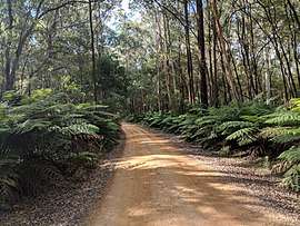 Monga National Park | |||||||||||||||
Monga Location in New South Wales | |||||||||||||||
| Coordinates | 35°34′57″S 149°55′02″E | ||||||||||||||
| Population | 14 (2016 census)[1] | ||||||||||||||
| Postcode(s) | 2622 | ||||||||||||||
| Location | |||||||||||||||
| LGA(s) | Queanbeyan-Palerang Regional Council | ||||||||||||||
| Region | Southern Tablelands | ||||||||||||||
| County | St Vincent | ||||||||||||||
| Parish | Monga | ||||||||||||||
| State electorate(s) | Monaro | ||||||||||||||
| Federal Division(s) | Eden-Monaro | ||||||||||||||
| |||||||||||||||
Nearby Mongarlowe, which in the 19th century was a much bigger settlement, was called Monga until 1891.[5]
References
- Australian Bureau of Statistics (27 June 2017). "Monga". 2016 Census QuickStats. Retrieved 14 March 2018.

- "Monga". Geographical Names Register (GNR) of NSW. Geographical Names Board of New South Wales. Retrieved 14 March 2018.
- "Monga". OpenStreetMap. Retrieved 14 March 2018.
- "Monga school (2) in the School history database search". New South Wales Department of Education. Retrieved 14 March 2018.
- Information sign at Mongarlowe
| Queanbeyan suburbs |
|
|---|---|
| Localities and rural places |
|
Main Article: Local government areas of New South Wales | |
This article is issued from Wikipedia. The text is licensed under Creative Commons - Attribution - Sharealike. Additional terms may apply for the media files.