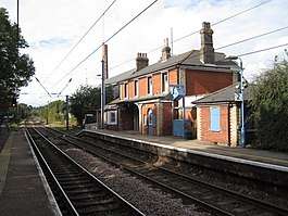
Mistley railway station
Mistley railway station is on the Mayflower Line, a branch of the Great Eastern Main Line in the East of England, serving the village of Mistley, Essex. It is 61 miles 14 chains (98.45 km) down the line from London Liverpool Street and is situated between Manningtree to the west and Wrabness to the east. Its three-letter station code is MIS.
| Mistley | |
|---|---|
 The station in 2012 | |
| Location | |
| Place | Mistley |
| Local authority | Tendring |
| Grid reference | TM118317 |
| Operations | |
| Station code | MIS |
| Managed by | Greater Anglia |
| Number of platforms | 2 |
| DfT category | F1 |
| Live arrivals/departures, station information and onward connections from National Rail Enquiries | |
| Annual rail passenger usage* | |
| 2014/15 | |
| 2015/16 | |
| 2016/17 | |
| 2017/18 | |
| 2018/19 | |
| History | |
| Key dates | Opened 1854 |
| National Rail – UK railway stations | |
| * Annual estimated passenger usage based on sales of tickets in stated financial year(s) which end or originate at Mistley from Office of Rail and Road statistics. Methodology may vary year on year. | |
The station was opened by the Eastern Union Railway in 1854. It is currently managed by Greater Anglia, which also operates all trains serving the station.
History

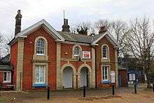
Mistley was opened by the Eastern Union Railway in 1854 and the brick-built two-storey Italianate station building (now in alternative use) was probably designed by Frederick Barnes.[1] The building is Grade II listed.
Platform 1 (London bound) and platform 2 (Harwich bound) have an operational length for four-coach trains.[2] There is a siding on the "up" (London-bound) side at the country (east) end which earlier had additionally included a long curved incline which allowed goods movements down to the quayside using horse power.[3] This was later replaced by a spur with a much steeper incline down to the quays on the down side at the country end.[4] At the London (west) end of the "down" side there are several sidings which were for movements to and from the malt works.[5]
There was a signal box at the London end of the "down" platform which having been taken out of service on the introduction of multiple aspect signalling in September 1985, was not allowed to be demolished as it was in a conservation area, so it was offered by Tendring Council and British Railways to the East Anglian Railway Museum at Chappel & Wakes Colne, to where it was moved in November 1985 and installed on to a brick base and today is again fully operational. Chappel & Wakes Colne.[6]
Services
As of December 2015 the typical weekday off-peak service on the line is one train per hour in each direction, although some additional services run at peak times. Trains operate between Harwich Town and Manningtree, calling at all stations, although some are extended to or from Colchester and/or London Liverpool Street. There is also one direct train a day on Monday to Fridays from Mistley to Ipswich (continuing on to Cambridge) during the morning peak,[7] which is operated by a diesel unit.
References
- Kay, Peter (2006). Essex Railway Heritage. Wivenhoe: Peter Kay. ISBN 978-1-899890-40-8.
- Brailsford, Martyn (2016). Railway Track Diagrams Volume 2 Eastern. Frome: Trackmaps. p. 9. ISBN 978-0-9549866-8-1.
- Mitchell, Vic (June 2011). Branch Lines to Harwich and Hadleigh. Midhurst: Middleton Press. plan III 1897 survey. ISBN 978-1-908174-02-4.CS1 maint: ref=harv (link)
- Mitchell 2011, plan III and plate 19
- Mitchell 2011, plan III and plate 24
- "East Anglian Railway Museum". Archived from the original on 27 June 2012. Retrieved 28 February 2012.
- Table 11 National Rail timetable, May 2016
| Wikimedia Commons has media related to Mistley railway station. |
External links
| Preceding station | Following station | |||
|---|---|---|---|---|
| Greater Anglia Mayflower Line | ||||
| Historical railways | ||||
Line and station open | Great Eastern Railway | Line open, station closed |
||