Mühlbachl
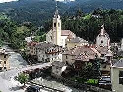
Mühlbachl is a municipality in the district Innsbruck-Land and is located 15 km south of Innsbruck. Mühlbachl extends from the southern slopes of Schönberg im Stubaital along Matreiwald to Steinach (to the aperture of the Navistal). It has 1349 inhabitants and the Sill River flows through it. Mühlbachl is aligned in many ways with Matrei am Brenner, Pfons and to some extent to Navis.
Mühlbachl | |
|---|---|
 | |
 Coat of arms | |
 Mühlbachl Location within Austria | |
| Coordinates: 47°08′10″N 11°27′07″E | |
| Country | Austria |
| State | Tyrol |
| District | Innsbruck Land |
| Government | |
| • Mayor | Alfons Rastner (Österreichische Volkspartei or ÖVP) |
| Area | |
| • Total | 28.85 km2 (11.14 sq mi) |
| Elevation | 995 m (3,264 ft) |
| Population (2018-01-01)[2] | |
| • Total | 1,393 |
| • Density | 48/km2 (130/sq mi) |
| Time zone | UTC+1 (CET) |
| • Summer (DST) | UTC+2 (CEST) |
| Postal code | 6143 |
| Area code | 05273 |
| Vehicle registration | IL |
| Website | www.muehlbachl.tirol.gv.at |
A famous place of pilgrimage, Maria Waldrast, can be reached by hiking up the mountain Serles to the west. The Serles is 2718 metres high.
Neighboring municipality
Ellbögen, Fulpmes, Matrei am Brenner, Mieders, Navis, Neustift im Stubaital, Pfons, Schönberg im Stubaital, Steinach am Brenner, Trins, Telfes im Stubai,
Population
| Year | Pop. | ±% |
|---|---|---|
| 1869 | 679 | — |
| 1880 | 749 | +10.3% |
| 1890 | 721 | −3.7% |
| 1900 | 852 | +18.2% |
| 1910 | 990 | +16.2% |
| 1923 | 958 | −3.2% |
| 1934 | 1,007 | +5.1% |
| 1939 | 985 | −2.2% |
| 1951 | 1,095 | +11.2% |
| 1961 | 1,140 | +4.1% |
| 1971 | 1,147 | +0.6% |
| 1981 | 1,290 | +12.5% |
| 1991 | 1,380 | +7.0% |
| 2001 | 1,375 | −0.4% |
| 2011 | 1,344 | −2.3% |
gollark: ++delete <@319753218592866315> (badness)
gollark: The canonical copy is on github for historical reasons.
gollark: It is, there's a mirror.
gollark: LyricLy deserves to experience bees for what he did.
gollark: https://github.com/osmarks/autobotrobot/pull/1 is a PRETTY apioformic PR.
References
- "Dauersiedlungsraum der Gemeinden Politischen Bezirke und Bundesländer - Gebietsstand 1.1.2018". Statistics Austria. Retrieved 10 March 2019.
- "Einwohnerzahl 1.1.2018 nach Gemeinden mit Status, Gebietsstand 1.1.2018". Statistics Austria. Retrieved 9 March 2019.
This article is issued from Wikipedia. The text is licensed under Creative Commons - Attribution - Sharealike. Additional terms may apply for the media files.