Mélykút
Mélykút (Croatian: Miljkut) is a town in Bács-Kiskun county, in the Southern Great Plain region of southern Hungary in Bacska [Page of Bacska]
Mélykút | |
|---|---|
 Flag  Coat of arms | |
 Mélykút | |
| Coordinates: 46.2139°N 19.3796°E | |
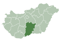
| Country | |
| County | Bács-Kiskun |
| District | Jánoshalma |
| Area | |
| • Total | 123.5 km2 (47.7 sq mi) |
| Population (2005) | |
| • Total | 5,775 |
| • Density | 46.76/km2 (121.1/sq mi) |
| Time zone | UTC+1 (CET) |
| • Summer (DST) | UTC+2 (CEST) |
| Postal code | 6449 |
| Area code | (+36) 77 |
| Website | www |
Geography
It covers an area of 123.5 km2 (48 sq mi) and has a population of 5180 people (2007).
gollark: I managed to dredge up relevant information from my browser history.
gollark: No, I mean they run the biggest ad exchange thing, and do some tricks to make competitors to them in any of the area unviable.
gollark: It could probably be one of those prisoner's dilemma situations. More so than regular advertising.
gollark: It's not just or necessarily that. They have some ridiculous monopolistic things going on.
gollark: ···
References
External links
| Wikimedia Commons has media related to Mélykút. |
- Official website in Hungarian
| Towns (2) |
| |
|---|---|---|
| Villages (3) | ||

This article is issued from Wikipedia. The text is licensed under Creative Commons - Attribution - Sharealike. Additional terms may apply for the media files.