Dunaegyháza
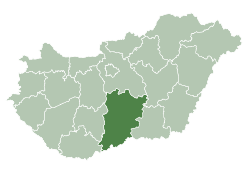
Dunaegyháza is a village in Bács-Kiskun county, in the Southern Great Plain region of Hungary.
Dunaegyháza | |
|---|---|
| Country | |
| County | Bács-Kiskun |
| Area | |
| • Total | 10.12 km2 (3.91 sq mi) |
| Population (2015) | |
| • Total | 1,389[1] |
| • Density | 137.3/km2 (356/sq mi) |
| Time zone | UTC+1 (CET) |
| • Summer (DST) | UTC+2 (CEST) |
| Postal code | 6323 |
| Area code(s) | 78 |
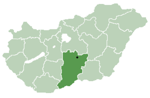
Location of Bács-Kiskun
county in Hungary
Geography
It covers an area of 10.12 km2 (4 sq mi) and has a population of 1389 people (2015).[1]

gollark: *broken*
gollark: According to my personal research, wants *are*:* stuff the moderator who posted last agrees withand wants are *not*:* stuff the moderator who posted last disagrees with* stuff people want to use the box for
gollark: "I know because I am a moderator, which means I am always right."
gollark: "You can totally derive half a page of rules from that one sentence and snippets of 6-year-old banning-actual-site-features T&C!"
gollark: Ah, yes, *that*.
References
- Gazetteer of Hungary, 1 January 2015. Hungarian Central Statistical Office. 3 September 2015
This article is issued from Wikipedia. The text is licensed under Creative Commons - Attribution - Sharealike. Additional terms may apply for the media files.