Dunafalva
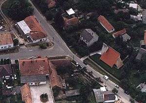
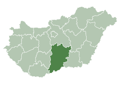
Dunafalva (Croatian: Topolovac) is a village and municipality in Bács-Kiskun county, in the Southern Great Plain region of southern Hungary.
Dunafalva Contra Florentiam (in Latin) | |
|---|---|
 | |
 Dunafalva Location of Dunafalva | |
| Coordinates: 46.0833°N 18.7833°E | |
| Country | |
| County | Bács-Kiskun |
| Area | |
| • Total | 57.89 km2 (22.35 sq mi) |
| Population (2015) | |
| • Total | 905[1] |
| • Density | 15.6/km2 (40/sq mi) |
| Time zone | UTC+1 (CET) |
| • Summer (DST) | UTC+2 (CEST) |
| Postal code | 6513 |
| Area code(s) | (+36) 69 |
History
The village was established in 1954 by Dunaszekcsőnek lying on the left side of the outer parts of the Danube.
Geography
It covers an area of 57.89 km2 (22 sq mi) and has a population of 905 people (2015).[1]
Demographics
gollark: Which are even worse on servers, since cloud platforms run VMs containing not-really-trusted code, while on consumer machines you could *maybe* get away with turning mitigations off since you don't.
gollark: Ryzen has the great advantage of not gaining exciting new vulnerabilities every month, too.
gollark: I think RX 570s are still pretty cheap compared to Nvidia equivalents.
gollark: ... are you ignoring cost here?
gollark: I just go for whichever one actually works best instead of supporting one for no good reason.
References
- Gazetteer of Hungary, 1 January 2015. Hungarian Central Statistical Office. 3 September 2015
This article is issued from Wikipedia. The text is licensed under Creative Commons - Attribution - Sharealike. Additional terms may apply for the media files.

