Harta, Hungary
Harta (German: Hartau, Croatian: Hartava and Kartava) is a village in Bács-Kiskun county, Hungary.
Harta Hartau (in German) | |
|---|---|
Large village | |
 Coat of arms | |
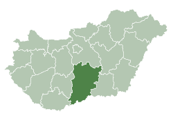
 Harta Location of Harta | |
| Coordinates: 46.693°N 19.031°E | |
| Country | |
| County | Bács-Kiskun |
| District | Kalocsa |
| Area | |
| • Total | 129.68 km2 (50.07 sq mi) |
| Population (2001) | |
| • Total | 3,758 |
| • Density | 29/km2 (80/sq mi) |
| Time zone | UTC+1 (CET) |
| • Summer (DST) | UTC+2 (CEST) |
| Postal code | 6326 |
| Area code | (+36) 78 |
Demography
gollark: You can use software USB things still.
gollark: Maybe not. How apioform.
gollark: Most microcontrollers will have some sort of debugger capability which lets you use some extra hardware to program them even if you beeize the bootloader or something.
gollark: In the worst case you can probably just something something JTAG if you have a thing for that.
gollark: I have no idea.
References
- "Hrvatski glasnik" (PDF) (in Croatian). Archived from the original (PDF) on 2011-07-21. (910 KB) Racke Pinkuše, 2. lipnja 2005.
External links
![]()
- Official website in Hungarian
- (in Hungarian) Harta a Vendégvárón
- (in Hungarian) HartaPortal - hírek Hartáról
| Towns (3) | ||
|---|---|---|
| Large villages (2) | ||
| Villages (18) | ||

| Authority control |
|---|
This article is issued from Wikipedia. The text is licensed under Creative Commons - Attribution - Sharealike. Additional terms may apply for the media files.