Luang Prabang Range
The Luang Prabang Range (Thai: ทิวเขาหลวงพระบาง, pronounced [tʰīw kʰǎw lǔaŋ pʰráʔ.bāːŋ]), named after Luang Prabang, is a mountain range straddling northwestern Laos and Northern Thailand. Most of the range is located in Sainyabuli Province (Laos), as well as Nan and Uttaradit Provinces (Thailand), with small parts in Phitsanulok and Loei Provinces. Several rivers such as the Nan, Pua and Wa river, have their source in this range.[1] Phu Fa waterfall, the biggest and the tallest waterfall in Nan Province, is also located in these mountains. This range is part of the Luang Prabang montane rain forests ecoregion.[2]
| Luang Prabang Range | |
|---|---|
| ทิวเขาหลวงพระบาง | |
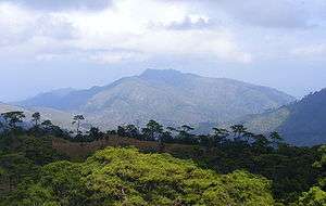
 Noen 1428 (Hill no. 1428), the battlefield of the Thai–Laotian Border War of 1988; view from Phu Soi Dao National Park, Phitsanulok Province, Thailand | |
| Highest point | |
| Peak | Phu Soi Dao |
| Elevation | 2,120 m (6,960 ft) |
| Coordinates | 18°35′16″N 98°29′13″E |
| Dimensions | |
| Length | 280 km (170 mi) N/S |
| Width | 85 km (53 mi) E/W |
| Geography | |
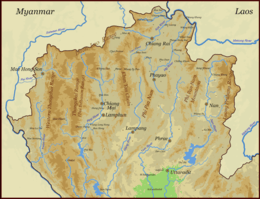
 Location of the Luang Prabang Range in Southeast Asia
| |
| Countries | Thailand and Laos |
| Geology | |
| Age of rock | Triassic |
| Type of rock | granite and sandstone |


Geologically its composition is similar to that of the parallel Khun Tan Range and the Phi Pan Nam Range, both located further west.[3]
Geography
The Luang Prabang mountains are the easternmost range of the Thai highlands. The range runs roughly in a North/South direction between the Mekong and the Nan River. Its northern end begins in the area of Hongsa District, a stretch in Laos near Luang Prabang where the Mekong River flows from west to east; its southern end is about 260 km further south, at the western end of Loei Province in Thailand where the Phetchabun Mountains begin. The highest point of the range is 2,120 m high Phu Soi Dao. Other high peaks of the Luang Prabang Range are 2,079 m high Phu Khe, 1,980 m high Doi Phu Kha, 1,837 m high Doi Phu Wae and 1,745 m high Doi Phi Pan Nam; Phu Khe is one of the ultra prominent peaks of Southeast Asia.[4] Many of the important peaks are located at the border.
The vegetation is evergreen hill forest on the highest altitudes of the range height and mostly dry deciduous forest below 1,000 m, with an abundance of teak trees, which has led to heavy deforestation. Like in most ranges of the area, a great proportion of the original forest cover has disappeared owing to shifting agricultural practices and illegal logging.[5] The area is allegedly a heartland for military involvement in timber trade.[6]
The Luang Prabang Range is practically devoid of vehicle roads on the Sainyabuli Province side, where there is only one north-south route extending from Sainyabuli, the provincial capital, to the Thai border opposite Thailand's Loei Province.
History

In 1904 the Laotian area of the range was ceded from Siam to the French Indochina colony. Following the Franco-Thai War in 1941 it was annexed by Thailand again under the name Lan Chang (Million Elephants) Province, but returned to its pre-war status in 1946 following the 1946 Washington Accord.[7]
Certain Hill tribe communities live in the range, like the Khmu and the Hmong, whose tribal villages are located on both sides of the mountain range. Since the Mekong isolated Sainyabuli from other Laotian provinces with Hmong villages, the warfare during the Quiet War which so badly affected other Hmong communities in Laos largely did not affect the Hmong in the Luang Prabang Range. Most Hmong villages in Sainyabuli Province did not see any fighting.[8] However, later they were persecuted all the same by the Vietnamese and the Pathet Lao soldiers, who regarded them as traitors, thus many fled across the border.[8] There are refugee camps on the Thai side of the range.[9]
The southern part of the range saw some confrontation between December 1987 and February 1988 when Thai and Laotian forces engaged in cross-border fighting. Known as Thai–Laotian Border War, this short conflict was caused by a dispute involving the map made by French surveyors in 1907 to mark the borders between Siam and French Indochina. The Thai-Lao Joint Boundary Commission (JBC) was established in 1996 to clarify the 1,810-kilometre boundary and settle ownership of the disputed villages. Border demarcation is still going on.[10]
Yetis are said to have been spotted in the remote Mae Charim area of the range.[11]
Tourism
Presently on the Thai side of the Luang Prabang Range some of the Hmong communities are regularly visited by organized tourist groups.[12] River Wa is a popular river for white water rafting between July and December.[13]
Protected areas
There are large swathes of protected areas on the Thai side of the Luang Prabang Range. On the Lao side there is only one.
In Laos
The Nam Phouy National Biodiversity Conservation Area, a large protected area in Laos home to many wild elephants, is located in a forested sector close to the Thai border.[14] The projected reservoir of Lower Nam Phoun dam,[15] however, is partly within the Nam Phouy NBCA and a large zone of the protected area will be flooded in the future.[16]
In Thailand
Khun Nan National Park,[17] Doi Phu Kha National Park, Sinan National Park, Mae Charim National Park,[18] Na Haeo National Park,[19] Klong Tron National Park,[20] Phu Suan Sai National Park and Phu Soi Dao National Park are located on the Thai side of the Luang Prabang Range.[21] Phu Miang-Phu Thong Wildlife Sanctuary is another protected area on the Thai side.[22]
See also
References
- Heritage, Northern Thailand Archived 2012-01-28 at the Wayback Machine
- World Wildlife Fund. "Luang Prabang montane rain forests".
- "geology of Thailand".
- "Phou Khe - Peakbagger.com".
- Lindsay Falvey, Cattle and Sheep in Northern Thailand, Chiang Mai (1979). 104pp
- Walker, Andrew (1999). The legend of the golden boat: regulation, trade and traders in the borderlands of Laos, Thailand, China, and Burma. University of Hawaii Press. p. 179. ISBN 978-0-8248-2256-9. Retrieved 27 June 2011.
- "Thailand's War With Vichy France".
- Fadiman, Anne. "Flight." The Spirit Catches You and You Fall Down. Farrar, Straus and Giroux. 1997. 155.
- "Mae Charim, Thailand".
- Supalak Ganjanakhundee (March 8, 2007). "Lao border talks progressing". National news. The Nation (Thailand). Archived from the original on October 5, 2012. Retrieved February 8, 2011.
Officials from both sides will start to conduct aerial photography for mapping this month before beginning the demarcation process and plan to complete the task by 2010.
- "Thailand". Travelfish.
- The Politics of Ethnic Tourism in Northern Thailand
- "Nan Province & Nam Wa River - Sop Mang Village to Mae Charim National Park". Archived from the original on 2014-10-07. Retrieved 2012-01-11.
- UNOSAT Map
- "As some reservoir area of Lower Nam Phoun damsite is in Nam 的翻译是: 什么意思? 中文翻译英文,英文翻译中文,怎么说?-青云在线翻译网".
- Tracy B. "Sponsorship_ElefantAsia_Adopt an elephant". Issuu.
- Khun Nan National Park
- "Mae Charim national park, Nan province, northern Thailand".
- "Na Haew - Protected Planet".
- "Protected Planet".
- "ภูสอยดาว ข้อมูลท่องเที่ยว ทัวร์ภูสอยดาว ทัวร์ดอย".
- "Phu Miang - Phu Thong - Protected Planet".
External links
| Wikimedia Commons has media related to Luang Prabang Range. |
- "Luang Prabang montane rain forests". Terrestrial Ecoregions. World Wildlife Fund.
- Google Books, The Physical Geography of Southeast Asia
- Map of Laos (physical)
- Forest cover in Laos
- Lao People’s Democratic Republic - National Report on Protected Areas and Development
- Existing and Planned Lao Hydropower Projects – 1 July 2009