Phitsanulok Province
Phitsanulok (Thai: พิษณุโลก, pronounced [pʰít.sā.nú.lôːk]), one of Thailand's seventy-six provinces, lies in lower northern Thailand. It borders Sukhothai and Uttaradit on the north, Loei and Phetchabun to the east, and Phichit and Kamphaeng Phet to the south. In the northeast it borders Laos.
Phitsanulok พิษณุโลก | |
|---|---|
 Nakhon Chum Village, Nakhon Thai in the area of Phu Hin Rong Kla National Park | |
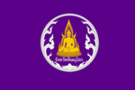 Flag 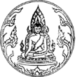 Seal | |
| Nickname(s): Song Khwae (two tributaries) | |
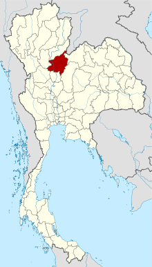 Map of Thailand highlighting Phitsanulok Province | |
| Country | Thailand |
| Capital | Phitsanulok |
| Government | |
| • Governor | Ronnachai Chitwiset (since 2020) |
| Area | |
| • Total | 10,816 km2 (4,176 sq mi) |
| Area rank | Ranked 16th |
| Population (2018)[2] | |
| • Total | 866,891 |
| • Rank | Ranked 28th |
| • Density | 80/km2 (200/sq mi) |
| • Density rank | Ranked 62nd |
| Human Achievement Index | |
| • HAI (2017) | 0.5895 "average" Ranked 35th |
| Time zone | UTC+7 (ICT) |
| Postal code | 65xxx |
| Calling code | 055 |
| ISO 3166 code | TH-65 |
| Vehicle registration | พิษณุโลก |
| Founded | 11th century |
| Website | www |
Its name means 'Vishnu's heaven'. The first element, Phitsanu (Thai: พิษณุ), is a cognate of "Vishnu", a Hindu god. The second element lok (Thai: โลก) means 'globe' or 'world'.
The capital is Phitsanulok.
History
The lands of present-day Phitsanulok Province were inhabited since the Stone Age, although the Neolithic inhabitants of the region are not likely to have been the ancestors of the modern Thai people who reside there today. The earliest historical records relating to the area indicate that at a time prior to or during the 11th century, the present-day city of Phitsanulok was a small strategic Khmer outpost known as Song Khwae. During the next century, in 1188, Nakhon Thai, near the center of the present Phitsanulok Province, was established as the capital city of the Singhanavati Kingdom, an early city-state of Thailand. Later, during Thailand's Sukhothai Period, the city of Phitsanulok emerged as a major city in the east of the Sukhothai Kingdom, and the great temples of Wat Chula Manee, Wat Aranyik and Wat Chedi Yod Thong were constructed. In 1357, the renowned Wat Phra Sri Rattana Mahathat was erected, and the Ayutthaya Period witnessed the construction of several of the province's other chief temples. Phitsanulok served for 25 years as the capital city of the Ayutthaya Kingdom. In 1555, King Naresuan the Great was born in Phitsanulok. Naresuan played a significant role in the history of Thailand, as he expanded the kingdom (then called Siam) to its greatest territorial extent by conquering sizable portions of modern-day Burma and Cambodia. In recent times, Phitsanulok Province has become an important agricultural center, part of the "bread basket of Thailand", providing rice and other crops to consumers in Thailand and throughout the world. Extensive agricultural development over the last hundred years or so has spawned a modern infrastructure in the urban areas of the province, bringing with it an array of modern roads, universities, hospitals and other conveniences. Over the years, the Nan River and its tributaries have played a substantial role in the history and development of the region by providing a route for transportation, fertile soil for agriculture, and water for irrigation. The river waters have also served as a route for enemy invaders, and have been the source of periodic widespread flooding throughout the province.
Symbols
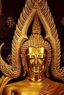
- The provincial seal depicts Phra Buddha Chinnarat, considered one of the most beautiful Buddha figures in Thailand.
- The provincial flag is purple with the provincial seal in the middle of the flag.
- The provincial tree is the tree jasmine, Thai dok phip ดอกปีบ or kasalong กาสะลอง.
- The provincial flower is the yellow flame tree, Thai dok nonthri ดอกนนทรี.
- The provincial animal is the Thai Bangkaew Dog, in Thai sunakh bangkaew สุนัขบางแก้ว.
- The provincial mascot is the yellow white tail fighting cock, Thai kai lueng hang khao ไก่เหลืองหางขาว.
- The provincial motto is, "Phitsanulok, a town of the excellent Phra Buddha Chinnarat, the birthplace of King Naresuan the Great, a raft community, with delicious dried bananas as well as fantastic caves and waterfalls".[4]
National parks

Religion
As of 2010 the population of Phitsanulok was 95 percent Buddhist with some 500 temples in the province.
A few of the some 100 temples in Mueang Phitsanulok district are:
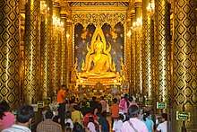
- Wat Phra Si Rattana Mahathat (royal temple with Buddha Chinnarat)
- Wat Chulamani (oldest standing temple in Phitsanulok province)
- Wat Aranyik (historic temple)
- Wat Chan Tawan Tok (with 60 meter high sala under construction)
The other eight districts have the following numbers of temples:
- Nakhon Thai district: some 50 temples
- Chat Trakan district: some 30 temples
- Bang Rakam district: some 70 temples
- Bang Krathum district: some 40 temples
- Phrom Phiram district: some 60 temples
- Wat Bot district: some 30 temples
- Wang Thong district: some 80 temples
- Noen Maprang district: some 40 temples
List of temples in Phitsanulok Province
Administrative divisions
Phitsanulok province is divided into nine districts (amphoe). These are further subdivided into 93 subdistricts (tambon) and 1052 villages (muban).[2] As of 26 November 2019 for local government there are[5]: one Phitsanulok Provincial Administrative Organisation - PPOA (ongkan borihan suan changwat phitsanulok) and 26 municipal (thesaban) areas in the province. Phitsanulok has city (thesaban nakhon) status, Aranyik has town (thesaban mueang) status and 24 subdistrict municipalities (thesaban tambon). The non-municipal areas are administered by 76 Subdistrict Administrative Organisations - SAO (ongkan borihan suan tambon).
| Districts, Phitsanulok Province | # | Name | Thai | Population | Tambon | Muban |
|---|---|---|---|---|---|---|
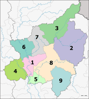 | ||||||
| 1 | Mueang Phitsanulok | เมืองพิษณุโลก | 291,642 | 20 | 177 | |
| 2 | Nakhon Thai | นครไทย | 87,647 | 11 | 145 | |
| 3 | Chat trakan | ชาติตระการ | 41,329 | 6 | 72 | |
| 4 | Bang Rakam | บางระกำ | 95,028 | 11 | 142 | |
| 5 | Bang Krathum | บางกระทุ่ม | 47,551 | 9 | 87 | |
| 6 | Phrom Phiram | พรหมพิราม | 86,682 | 12 | 123 | |
| 7 | Wat Bot | วัดโบสถ์ | 37,777 | 6 | 61 | |
| 8 | Wang Thong | วังทอง | 121,190 | 11 | 168 | |
| 9 | Noen Maprang | เนินมะปราง | 58,045 | 7 | 77 |
Transport
Air
Phitsanulok is served by Phitsanulok Airport.
Rail
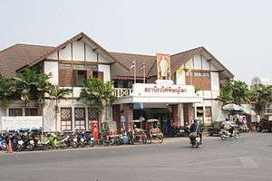
Phitsanulok's main station is Phitsanulok Railway Station.
Health
Phitsanulok's main hospital is Buddhachinaraj Phitsanulok Hospital, operated by the Ministry of Public Health.
Human achievement index 2017
| Health | Education | Employment | Income |
| 62 | 28 | 40 | 47 |
| Housing | Family | Transport | Participation |
 |
 |
||
| 32 | 53 | 24 | 49 |
| Province Phitsanulok, with an HAI 2017 value of 0.5895 is "average", occupies place 35 in the ranking. | |||
Since 2003, United Nations Development Programme (UNDP) in Thailand has tracked progress on human development at sub-national level using the Human achievement index (HAI), a composite index covering all the eight key areas of human development. National Economic and Social Development Board (NESDB) has taken over this task since 2017.[3]
| Rank | Classification |
| 1 - 15 | "high" |
| 16 - 30 | "somewhat high" |
| 31 - 45 | "average" |
| 45 - 60 | "somewhat low" |
| 61 - 77 | "low" |
| Map with provinces and HAI 2017 rankings |
 |
See also
| Thai Wikisource has original text related to this article:
History of Phitsanulok by Prince Damrong |
Notes
Reports (data) from Thai government are "not copyrightable" (Public Domain), Copyright Act 2537 (1994), section 7.
References
- Advancing Human Development through the ASEAN Community, Thailand Human Development Report 2014, table 0:Basic Data (PDF) (Report). United Nations Development Programme (UNDP) Thailand. pp. 134–135. ISBN 978-974-680-368-7. Retrieved 17 January 2016, Data has been supplied by Land Development Department, Ministry of Agriculture and Cooperatives, at Wayback Machine.
- "รายงานสถิติจำนวนประชากรและบ้านประจำปี พ.ศ.2561" [Statistics, population and house statistics for the year 2018]. Registration Office Department of the Interior, Ministry of the Interior (in Thai). 31 December 2018. Retrieved 20 June 2019.
- Human achievement index 2017 by National Economic and Social Development Board (NESDB), pages 1-40, maps 1-9, retrieved 14 September 2019, ISBN 978-974-9769-33-1
- "คำขวัญพิษณุโลก" [Phitsanulok motto]. Mthai (in Thai). 2013-11-10. Retrieved 2020-03-03.
- "Number of local government organizations by province". dla.go.th. Department of Local Administration (DLA). 26 November 2019. Retrieved 10 December 2019.
36 Phitsanulok: 1 PAO, 1 City mun., 1 Town mun., 24 Subdistrict mun., 76 SAO.
External links
Places adjacent to Phitsanulok Province | |
|---|---|