Lowell, Kansas
Lowell is an unincorporated community in Cherokee County, Kansas, United States. As of the 2010 census, the CDP population was 283.[1]
Lowell, Kansas | |
|---|---|
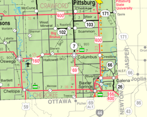 KDOT map of Cherokee County (legend) | |
 Lowell  Lowell | |
| Coordinates: 37°02′55″N 94°42′05″W | |
| Country | United States |
| State | Kansas |
| County | Cherokee |
| Area | |
| • Total | 0.33 sq mi (0.86 km2) |
| • Land | 0.31 sq mi (0.81 km2) |
| • Water | 0.02 sq mi (0.05 km2) |
| Elevation | 850 ft (260 m) |
| Population | |
| • Total | 283 |
| • Density | 850/sq mi (330/km2) |
| Time zone | UTC-6 (CST) |
| • Summer (DST) | UTC-5 (CDT) |
| ZIP codes | 66713, 66739 |
| Area code | 620 |
| FIPS code | 20-43050[2] |
| GNIS ID | 0469344[2] |
History
A post office was opened in Lowell in 1868, and remained in operation until it was discontinued in 1905.[3]
Geography
Lowell is located in southeastern Cherokee County near the southeastern corner of Kansas. It is bordered to the north by the Spring River, a tributary of the Neosho River. Across the river is the community of Riverton. Baxter Springs is 4 miles (6 km) by road to the southwest.
Demographics
For statistical purposes, the United States Census Bureau has defined Lowell as a census-designated place (CDP).
gollark: Also, ew.
gollark: And that has a GPU, yes.
gollark: Anyway, does your emulator not have a concept of "clock cycles" or something similar?
gollark: Yes you do.
gollark: I would recommend using the GPU to emulate your GPU, as a cool™ GPU has several thousand "threads".
References
- "Geographic Identifiers: 2010 Demographic Profile Data (G001): Lowell CDP, Kansas". U.S. Census Bureau, American Factfinder. Archived from the original on February 12, 2020. Retrieved August 4, 2014.
- "US Board on Geographic Names". United States Geological Survey. 2007-10-25. Retrieved 2008-01-31.
- "Kansas Post Offices, 1828-1961 (archived)". Kansas Historical Society. Archived from the original on 9 October 2013. Retrieved 6 June 2014.
Municipalities and communities of Cherokee County, Kansas, United States | ||
|---|---|---|
| Cities | 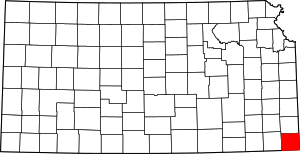 Map of Kansas highlighting Cherokee County | |
| CDPs | ||
| Unincorporated communities | ||
| Ghost towns | ||
| Townships | ||
| Footnotes | ‡This populated place also has portions in an adjacent county or counties | |
This article is issued from Wikipedia. The text is licensed under Creative Commons - Attribution - Sharealike. Additional terms may apply for the media files.