Lola Township, Cherokee County, Kansas
Lola Township is a township in Cherokee County, Kansas, USA. As of the 2000 census, its population was 382.
Lola Township | |
|---|---|
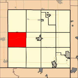 Location in Cherokee County | |
| Coordinates: 37°09′30″N 095°01′55″W | |
| Country | United States |
| State | Kansas |
| County | Cherokee |
| Area | |
| • Total | 44.72 sq mi (115.82 km2) |
| • Land | 44.49 sq mi (115.24 km2) |
| • Water | 0.22 sq mi (0.58 km2) 0.5% |
| Elevation | 830 ft (253 m) |
| Population (2000) | |
| • Total | 382 |
| • Density | 8.6/sq mi (3.3/km2) |
| GNIS feature ID | 0469277 |
Geography
Lola Township covers an area of 44.72 square miles (115.8 km2) and contains no incorporated settlements. According to the USGS, it contains four cemeteries: Cherokee, Dove, Garrison and Spickelmire.
The streams of Deer Creek, Denny Branch, Fly Creek, Fourmile Creek, Lightning Creek and Wolf Creek run through this township.
Transportation
Lola Township contains one airport or landing strip, Oswego Municipal Airport.
gollark: Oh, you mean the malware is really stupid and uses a hardcoded key?
gollark: I know what XOR is. I just think you're missing the point.
gollark: I'm not convinced you understand what I'm talking about here. 018249 kOffense.
gollark: I see. What of it? That doesn't mean you can get data out, just that you can see roughly where the code for that is.
gollark: Do you mean that decryption code probably has XORs in it, or what?
External links
Municipalities and communities of Cherokee County, Kansas, United States | ||
|---|---|---|
| Cities | 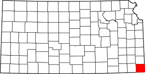 Map of Kansas highlighting Cherokee County | |
| CDPs | ||
| Unincorporated communities | ||
| Ghost towns | ||
| Townships | ||
| Footnotes | ‡This populated place also has portions in an adjacent county or counties | |
This article is issued from Wikipedia. The text is licensed under Creative Commons - Attribution - Sharealike. Additional terms may apply for the media files.