Sheridan Township, Cherokee County, Kansas
Sheridan Township is a township in Cherokee County, Kansas, United States. As of the 2000 census, its population was 249.
Sheridan Township | |
|---|---|
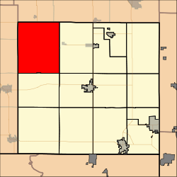 Location in Cherokee County | |
| Coordinates: 37°16′00″N 095°01′01″W | |
| Country | United States |
| State | Kansas |
| County | Cherokee |
| Area | |
| • Total | 67.07 sq mi (173.72 km2) |
| • Land | 66.54 sq mi (172.35 km2) |
| • Water | 0.53 sq mi (1.37 km2) 0.79% |
| Elevation | 840 ft (256 m) |
| Population (2000) | |
| • Total | 249 |
| • Density | 3.7/sq mi (1.4/km2) |
| GNIS feature ID | 0469476 |
Geography
Sheridan Township covers an area of 67.07 square miles (173.7 km2) and contains no incorporated settlements.
According to the United States Geological Survey (USGS), it contains eight cemeteries: Bowen, Friendship, Harley, LaRue, McKee, Rigney, Sherman, Star.
The streams of Little Cherry Creek, Mulberry Creek, Plum Creek and Stink Branch all run through the township.
gollark: Why not just run everything in kernel space?
gollark: No, SSE is to be enabled || bees.
gollark: Or just single-boot hellobOiS.
gollark: Fascinating.
gollark: Selfhosting involves having your OS able to build itself right? How do you get a C compiler extant?
External links
Municipalities and communities of Cherokee County, Kansas, United States | ||
|---|---|---|
| Cities | 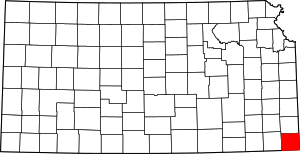 Map of Kansas highlighting Cherokee County | |
| CDPs | ||
| Unincorporated communities | ||
| Ghost towns | ||
| Townships | ||
| Footnotes | ‡This populated place also has portions in an adjacent county or counties | |
This article is issued from Wikipedia. The text is licensed under Creative Commons - Attribution - Sharealike. Additional terms may apply for the media files.