Pleasant View Township, Cherokee County, Kansas
Pleasant View Township is a township in Cherokee County, Kansas, USA. As of the 2000 census, its population was 658.
Pleasant View Township | |
|---|---|
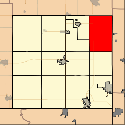 Location in Cherokee County | |
| Coordinates: 37°16′30″N 094°40′31″W | |
| Country | United States |
| State | Kansas |
| County | Cherokee |
| Area | |
| • Total | 52.44 sq mi (135.82 km2) |
| • Land | 52.37 sq mi (135.64 km2) |
| • Water | 0.07 sq mi (0.18 km2) 0.13% |
| Elevation | 860 ft (262 m) |
| Population (2000) | |
| • Total | 658 |
| • Density | 13/sq mi (4.8/km2) |
| GNIS feature ID | 0469334 |
Geography
Pleasant View Township covers an area of 52.44 square miles (135.8 km2) and contains no incorporated settlements. According to the USGS, it contains four cemeteries: Bird, Crocker, Lone Oak and Old Pleasant View.
The streams of Brush Creek, Long Branch and Taylor Branch run through this township.
gollark: Just constantly inject milk into your bloodstream.
gollark: This is unlikely.
gollark: Oh hey, it finished, that's unexpected.
gollark: Minecraft loads slowly enough that it should be up by the time I can join.
gollark: I'm joining to test my GPS patch.
External links
Municipalities and communities of Cherokee County, Kansas, United States | ||
|---|---|---|
| Cities | 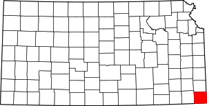 Map of Kansas highlighting Cherokee County | |
| CDPs | ||
| Unincorporated communities | ||
| Ghost towns | ||
| Townships | ||
| Footnotes | ‡This populated place also has portions in an adjacent county or counties | |
This article is issued from Wikipedia. The text is licensed under Creative Commons - Attribution - Sharealike. Additional terms may apply for the media files.