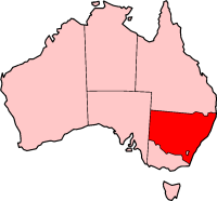
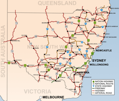
List of road routes in New South Wales
Road routes in New South Wales assist drivers navigating roads in urban, rural, and scenic areas of the state. Today, all numbered routes in the state are allocated a letter (M, A or B) in addition to a one- or -two digit number, with 'M' routes denoting motorways, 'A' routes denoting routes of national significance, and 'B' routes denoting routes of state significance. The route system includes the officially designated highways, urban and intercity motorways and arterial roads, and important cross-state roads that have not been declared highways.
History
Route numbers have been allocated to NSW roads since 1955. National Route 1 ('Highway 1') was one of the best known numbered national routes, likely because of its fame for circumnavigating the continent. The insignia of national routes was a five-sided black and white shield, chosen as it is the shape of the Australian national coat of arms.
To supplement the national route number system, three ring roads were introduced to Sydney in 1964.[1] These were numbered 1, 3 and 5, with relatively (but not proportionately) increasing radii. While they were officially decommissioned in 1974, some old ring road 3 signs remained posted into the 1980s, and ring road 1 signs into the 1990s.
In 1973, a system of freeway numbering was introduced to the state to complement the national routes and ring roads. The shields were replicas of the red, white and blue U.S. Interstate Highway shields, and were numbered F1 to F8:
- F1: Warringah Freeway, and its never-built extensions
- F2: reserved for the Castlereagh Freeway, a corridor similar to today's M2 Hills Motorway
- F3: Sydney–Newcastle Freeway (now Pacific Motorway), and the never-built Lane Cove Valley Expressway and North Western Expressway
- F4: Western part of today's M4 Western Motorway (formerly Western Freeway)
- F5: the freeway section of National Highway 31 (now Hume Motorway)
- F6: Southern Freeway (now Princes Motorway), and its never-built extensions to the Sydney CBD
- F7: reserved for a corridor along the alignment of the Cahill Expressway, Eastern Distributor and Bondi Junction Bypass
- F8: a section of Wollongong's Northern Distributor (now Memorial Drive)[2]
Most of these routes were replaced with other numbers over the decades, and by the 1990s, only the F1, F3 and F6 were still marked as such, with simpler, green-on-white shields. None of these shields remain, but the F3 and F6 are still usually called by those names.
In 1974, the National Highway network was defined, which in New South Wales included the Hume Highway, Federal Highway, Barton Highway, Sydney-Newcastle Freeway (now Pacific Motorway) and New England Highway.[3] National highways were marked with the same shield as the national routes, except for their green and gold colour and the word 'national' added across the top.
Also in 1974, the three ring roads, 1, 3 and 5, were decommissioned and replaced by new State Routes, which had the same shields as the new freeways but without the red crest. Scores of other State Routes were also designated across New South Wales, marking out urban arterial routes and secondary rural highways. They were allocated as follows:
- 11, 33 and 55: Respectively replaced ring roads 1, 3 and 5. In 1988, state route 77 was commissioned as an additional primary circumferential route.
- 12-76: Greater Sydney. Even numbers were radial while odd numbers were circumferential, roughly increasing in value anticlockwise around the City. Exceptions were State Route 31 (which replaced Metroad 5 when the South Western Motorway was extended easterly; Metroad 5 was a replacement of the metropolitan part of National Highway 31) and state route 60 (which is in Wollongong). Routes 36, 40, 56, 68 and 69 extended beyond the bounds of Greater Sydney. While most State Routes still appear on maps and in street directories, they were haphazardly removed and covered up in Sydney in 1998 and 2004, leaving only routes 29, 31, 40, 44, 54, 56, 60 and 69.
- 78-99: Rural Areas. There was no discernible pattern with these routes. State route 83 was commissioned in 1979 and state route 89 was commissioned in 1980.
- 111, 121-124, 128, 131-133, 135: Greater Newcastle. 111 was added in 1988 following National Highway 1's relocation to the F3 Freeway.
- 151, 153, 155 and 157: Greater Wollongong, in addition to state routes 60, 68, 69 and 88.
- 2: In 2008, Queensland's state route 2 from the Gold Coast was extended a short distance into far northern NSW.
In 1993, Sydney's Metroad system was introduced, with its prominent, blue-on-white hexagonal shields. There were initially six metroads: Metroad 1 replaced National Route 1 within the metropolitan area, Metroad 2 replaced parts of State Routes 28 and 30 (and was subsequently absorbed by the M2 Hills Motorway), Metroad 3 replaced State Route 33 (once Ring Road 3), Metroad 4 replaced the F4 Freeway and the metropolitan part of National Route 32, Metroad 5 replaced part of the metropolitan part of National Highway 31 and Metroad 7 replaced State Route 77. Later, Metroad 6 replaced State Route 45, Metroad 9 replaced the metropolitan part of State Route 69 and Metroad 10 replaced State Route 14 south of Mona Vale. There was never a Metroad 8 as Alpha Numerics came before the ![]()
In 2013, the state replaced its entire system of State Routes, National Routes, National Highways and Metroads with an alphanumeric route numbering system.[4] All numbered routes are allocated a letter (M, A, B or D) in addition to its number, with 'M' routes denoting motorways, 'A' routes denoting routes of national significance, and 'B' routes denoting routes of state significance. Instead of shields, the route numbers are displayed as yellow text on green rectangular background outlined in white. Now all old routes have changed except for 1 (SR2 to be with QLD) The changeover to alphanumeric routes was announced from March 2013 and signs were updated throughout 2013, either by removing old "shield" coverplates installed on newer signs, or installing new alphanumeric coverplates on old shielded signs. In 2020, the styling of the markers was modified to remove the white border, aligning with all other states except the ACT.[5]
Motorways (M routes)
| Route | Component roads | From | To | Length | Notes | |
|---|---|---|---|---|---|---|
| km | mi | |||||
M1 |
Pacific Motorway | QLD border | Ballina | 89 | 55 | |
| Pacific Motorway | Dirty Creek | Sapphire Beach | 35 | 22 | ||
| Pacific Motorway | Bonville | Thrumster | 141 | 88 | ||
| Pacific Motorway | Newcastle | Wahroonga | 127 | 79 | ||
| Gore Hill Freeway | Artarmon | Naremburn | 3 | 2 | ||
| Warringah Freeway | Naremburn | North Sydney | 4 | 2 | ||
| Sydney Harbour Tunnel | North Sydney | Sydney (City) | 2.8 | 2 | Toll Citybound | |
| Cahill Expressway | Sydney | Woolloomooloo | 0.9 | 1 | ||
| Eastern Distributor | Woolloomooloo | Kensington | 6 | 4 | Toll Citybound | |
| Princes Motorway | Waterfall | Yallah | 53 | 33 | ||
M2 |
Lane Cove Tunnel | Artarmon | North Ryde | 3.6 | 2 | Toll |
| Hills Motorway
Abbott Road |
North Ryde | Seven Hills | 21 | 13 | Toll | |
M4 |
Western Motorway | North Strathfield | Lapstone | 46 | 29 | Toll from North Strathfield to Merrylands |
| M4 East | Homebush | Haberfield | 5.5 | 3 | Toll | |
M5 |
M5 East | Mascot | Berverly Hills | 10 | 6 | Toll |
| South-West Motorway | Beverly Hills | Prestons | 21 | 13 | Toll from Beverly Hills to Glenfield | |
M7 |
Westlink M7 | Prestons | Seven Hills | 40 | 25 | Toll |
M8 |
M8 Motorway | Kingsgrove | St Peters | 9 | 6 | Toll |
M15 |
Hunter Expressway | Cameron Park | Belford | 39 | 24 | |
M23 |
Federal Highway | Yarra | ACT border | 66 | 41 | |
M31 |
Hume Motorway | Prestons (Sydney) | Berrima | 86 | 53 | |
| Hume Highway | Berrima | VIC Border | 425 | 264 | Formerly | |
Future road routes
F6 Extension - In 2019, the New South Wales Government announced it would rename the northern extension of the Princes Motorway, between Arncliffe and Kogarah (due to open in 2025) to the "M6 Motorway". No announcement has yet been made on whether the A6 will be renumbered to avoid duplicate numbers. (Wikipedia)
- Western Sydney Airport Motorway.
Routes of national significance (A routes)
| Route | Component roads | From | To | Length | Notes | |
|---|---|---|---|---|---|---|
| km | mi | |||||
A1 |
Pacific Highway | Ballina | Dirty Creek | 161 | 100 | Has Freeway Significance |
| Pacific Highway | Sapphire Beach | Bonville | 16 | 10 | Has Freeway Significance | |
| Pacific Highway | Thrumster | Hexham | 218 | 135 | Has Freeway Significance | |
| Pacific Highway (Sydney) | Wahroonga | Artarmon | 15 | 9 | ||
|
Kyeemagh | Brighton-Le-Sands | 3 | 2 | ||
| President Avenue | Brighton-Le-Sands | Kogarah | 2 | 1 | ||
| Princes Highway | Kogarah | Waterfall | 28 | 17 | ||
| Princes Highway | Albion Park | Victorian border | 420 | 261 | ||
A2 |
Seven Hills | Windsor | 21 | 13 | Separate South Eastern and North Western Routes
at Old Windsor Road at M2 M7 - M2 - Abbott Road | |
A3 |
|
Mona Vale | Blakehurst | 52 | 32 | |
A4 |
|
North Sydney | Ashfield | 12 | 7 | Toll on Bradfield Highway |
A6 |
Marsden Road | Carlingford | West Ryde | 2 | 1 | |
|
West Ryde | Dundas Valley | 0.85 | 1 | ||
| Silverwater Road | Dundas Valley | Auburn | 6 | 4 | ||
|
Auburn | Lucas Heights | 26 | 16 | ||
| Heathcote Road | Lucas Heights | Engadine | 5 | 3 | ||
A8 |
|
Mona Vale | Mosman | 20 | 12 | |
| Military Road | Mosman | North Sydney | 3 | 2 | ||
A9 |
|
Campbelltown | Cranebrook | 59 | 37 | |
| The Northern Road | Llandilo | Berkshire Park | 8 | 5 | ||
| Richmond Road | Berkshire Park | Londonderry | 0.25 | 0 | ||
|
South Windsor | Windsor | 5 | 3 | ||
A11 |
Pacific Highway | Pearces Corner | Unknown | N/A | N/A | This route in no longer in use |
A15 |
New England Highway | Branxton | Queensland border | 541 | 336 | |
|
Cameron Park | Newcastle West | 15 | 9 | ||
A20 |
Sturt Highway | Gundagai | Victorian border | 597 | 371 | |
A22 |
Chippendale | Summer Hill | 6 | 4 | ||
|
Summer Hill | Liverpool | 30 | 19 | ||
A25 |
Barton Highway | ACT border | Yass | 40 | 25 | Has freeway significance |
A28 |
Camden Valley Way
Hume Hwy James Ruse Dr Pennant Hills Road |
Wahroonga | Prestons | 42 | 26 | Has freeway significance at James Ruse Drive |
A32 |
Lapstone | Cockburn | 1,146 | 712 | ||
A34 |
|
Liverpool | Newtown | 26 | 16 | |
A36 |
Kogarah | Sydney | 11 | 7 | ||
A37 |
Newcastle Inner City Bypass | Windale | Sandgate | 16 | 10 | Has freeway significance |
A38 |
|
North Ryde | Dee Why | 18 | 11 | |
A39 |
Newell Highway | Victorian border | Queensland border | 1,059 | 658 | |
A40 |
Victoria Road
James Ruse Dr Old Windsor Rd |
Rozelle | West Baulkham Hills | 29 | 18 | Has freeway significance at James Ruse Drive |
A41 |
Bathurst | Albury | 423 | 263 | ||
A43 |
|
Warnervale | Branxton | 115 | 71 | Has Freeway Significance when with |
A44 |
Russell St
High St Castlereagh Rd Jane St High St Great Western Highway (Sydney) Parramatta Road Wattle St |
Strathfield | Emu Plains | 45 | 28 | |
A48 |
Illawarra Highway | Sutton Forest | Wollongong | 62 | 39 | |
A49 |
Central Coast Highway | Doyalson | Kariong | 50 | 31 | |
Routes of state significance (B routes)
| Route[6] | Component roads | From | To | Length | Notes | |
|---|---|---|---|---|---|---|
| km | mi | |||||
B23 |
Monaro Highway | ACT border | Victoria border | 204 | 127 | Formerly |
B51 |
Kamilaroi Highway | Willow Tree | Narrabri | 188 | 117 | |
B52 |
Kings Highway | ACT border | Batemans Bay | 115 | 71 | |
B53 |
|
Wallsend | Morisset | 35.2 | 22 | |
B55 |
Castlereagh Highway | Marrangaroo | Queensland border | 631 | 392 | |
B56 |
Oxley Highway | Port Macquarie | Coonabarabran | 448 | 278 | |
B57 |
|
Speers Point | Charlestown | 9.5 | 6 | |
B58 |
Riverina Highway | Deniliquin | Victorian border | 220 | 137 | |
B59 |
|
Vineyard | Lithgow | 90 | 56 | |
B60 |
Bruxner Highway | Ballina | Tenterfield | 185 | 115 | |
B62 |
Bangalow-Lismore Road | Ewingsdale | Lismore | 39.6 | 25 | |
B63 |
|
Kotara | Nelson Bay | 59.7 | 37 | |
B64 |
Mid-Western Highway | Cowra | Hay | 413 | 257 | |
B65 |
|
Bulli Tops | Shellharbour | 39 | 24 | |
B68 |
Cessnock Road
John Renshaw Drive |
Beresfield | Cessnock | 29.4 | 18 | |
B69 |
Appin Road | Campbelltown | Bulli Tops | 34.1 | 21 | |
B70 |
|
Warnervale | Noraville | 14 | 9 | |
B71 |
Mitchell Highway | Nyngan | Queensland border | 338 | 210 | |
B72 |
Snowy Mountains Highway | Steeple Flat | Stony Creek | 287 | 178 | Separate eastern and northern sections |
B73 |
|
Mittagong | Nowra | 68.2 | 42 | |
B74 |
Wyong Road | Tuggerah | Bateau Bay | 11.4 | 7 | |
B75 |
Cobb Highway | Wilcannia | Victoria border | 598 | 372 | |
B76 |
|
Tyndale | Bourke | 835 | 519 | |
B78 |
Waterfall Way | Urunga | Armindale | 165 | 103 | |
B79 |
Silver City Highway | Curlwaa | Broken Hill | 297 | 185 | |
B81 |
|
Yass | Molong | 215 | 134 | |
B82 |
|
Freemans Waterhole | Branxton | 50.4 | 31 | |
B83 |
Pacific Highway | Wahroonga | Somersby | 54.6 | 34 | |
B84 |
Golden Highway | Belford | Dubbo | 314 | 195 | |
B85 |
Goldfields Way | West Wylong | Junee | 113 | 70 | |
B87 |
Kidman Way | Jerilderie | Bourke | 644 | 400 | |
B88 |
Picton Road | Picton | Wollongong | 45 | 28 | |
B89 |
|
West Wallsend | Belmont | 22.9 | 14 | |
B91 |
|
Glenugie | Queensland border | 212 | 132 | [7] |
B94 |
Burley Griffin Way | Bowning | Griffith | 289 | 180 | |
B95 |
Fossickers Way | Tamworth | Yetman | 274 | 170 | |
B400 |
Murray Valley Highway | Euston | VIC Border | 2.6 | Not shown in Google maps | |
State Routes
State Route 2 |
Gold Coast Highway | Tweed Heads | Queensland Border | 3 | 2 | This Route is the extension of a QLD route |
|---|
D routes (detour routes)
![]()
![]()
Decommissioned Alpha Numeric Road Routes
A31 |
Hume Highway |
|---|---|
A46 |
Newcastle Link Road (Now A15) |
B80 |
Now B23 to remain the same with Victoria |
Minor arterial roads
- Alpine Way
- Barry Way
- Bathurst-Ilford Road
- Bucketts Way
- Bylong Valley Way
- Camden Valley Way
- Carnarvon Highway
- Escort Way
- Goulburn-Oberon Road
- Henry Lawson Way
- Irrigation Way
- Macleay Valley Way
- Murray Valley Highway
- O'Connell Road
- Old Hume Highway
- Putty Road
- Remembrance Drive
- Thunderbolts Way
- Wombeyan Caves Road
- Yass Valley Way
See also
- Highways in Australia for highways in other states and territories
- Highways in New South Wales for details about officially gazetted highways
References
- "Sydney Ring Roads". Ozroads. 28 August 1964. Retrieved 28 September 2013.
- "Northern Distributor". Ozroads. Retrieved 28 September 2013.
- "The National Highway System". Ozroads. 20 September 1974. Retrieved 28 September 2013.
- "Alpha Numeric route numbers - A new Road Numbering System". Transport for NSW - Roads and Maritime. Retrieved 9 June 2020.
- "Harmonisation of alpha numeric route markers with Australian Standard AS 1742.15" (PDF). 15 April 2020.
- "NSW alpha-numeric routes". Ozroads. 1 September 2013. Retrieved 28 September 2013.
- "Schedule of Classified Roads And State and Regional Roads" (PDF). Roads and Maritime Services. April 2017. p. 6 (Gazetted Road Number 83). Retrieved 8 January 2018.
Road infrastructure in regional New South Wales | ||
|---|---|---|
| Motorways | ||
| Major highways |
| |
| Minor highways |
| |
| Other roads |
| |
| Road bridges (disused/former) |
| |
| Vehicular ferries | ||
| Tunnels | ||