List of listed buildings in Renfrew, Renfrewshire
List
| Name | Location | Date Listed | Grid Ref. [note 1] | Geo-coordinates | Notes | LB Number [note 2] | Image |
|---|---|---|---|---|---|---|---|
| Broadloan, Muirpark Avenue, Muirpark House | 55°52′11″N 4°23′47″W | Category B | 42913 |  | |||
| Bank Of Scotland Hairst Street And High Street | 55°52′43″N 4°23′13″W | Category B | 40418 | | |||
| Bank Of Scotland, 1 High Street And Canal Street | 55°52′44″N 4°23′11″W | Category B | 40427 | | |||
| Paisley Road, Renfrew Trinity Church (Church Of Scotland), Including Boundary Walls, Gates And Gatepiers | 55°52′36″N 4°23′25″W | Category C(S) | 51286 | | |||
| Renfield Street, Renfrew North Parish Church With Boundary Walls, Railings, Gates And Gatepiers | 55°52′50″N 4°23′12″W | Category B | 44585 | | |||
| White Cart Bridge, Inchinnan Road, Over Part Of White Cart Water | 55°52′49″N 4°24′38″W | Category A | 40424 | | |||
| The Cross, Renfrew Town Hall | 55°52′44″N 4°23′14″W | Category A | 40430 | 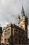 | |||
| Brown Institute, 41 Canal Street | 55°52′48″N 4°23′08″W | Category B | 40426 | 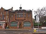 | |||
| Renfield Street, Formerly Renfrew Parish Council Chambers | 55°52′49″N 4°23′11″W | Category B | 40429 | | |||
| Ferry Inn, Ferry Road & Clyde Street, Renfrew Ferry | 55°53′08″N 4°23′00″W | Category C(S) | 40419 | 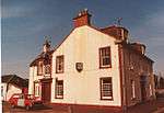 | |||
| Victory Baths, Inchinnan Road | 55°52′42″N 4°23′24″W | Category B | 40420 | 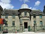 | |||
| 13, 15 And 17 Clyde Street | 55°53′10″N 4°23′05″W | Category C(S) | 43889 | | |||
| Wheatsheaf Public House, Canal Street | 55°52′45″N 4°23′13″W | Category C(S) | 40422 | | |||
| Rolling Lift Bridge Over White Cart Water | 55°52′48″N 4°24′35″W | Category A | 40425 | 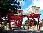 | |||
| Renfrew Old Parish Church High Street | 55°52′40″N 4°23′11″W | Category B | 40416 | | |||
| Two Monuments Within Renfrew Old Parish Church, High Street | 55°52′40″N 4°23′11″W | Category A | 40417 | | |||
| County Police Chambers, Inchinnan Road | 55°52′42″N 4°23′25″W | Category B | 40421 | 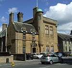 | |||
| Argyle Stone & St Conval's "Chariot" By Blythswood West Lodge Inchinnan Road | 55°52′48″N 4°24′28″W | Category B | 40423 | 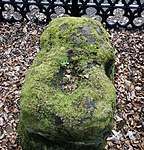 | |||
| 4-24 (Even Nos) High Street | 55°52′42″N 4°23′12″W | Category B | 40428 | |
Key
The scheme for classifying buildings in Scotland is:
- Category A: "buildings of national or international importance, either architectural or historic; or fine, little-altered examples of some particular period, style or building type."[1]
- Category B: "buildings of regional or more than local importance; or major examples of some particular period, style or building type, which may have been altered."[1]
- Category C: "buildings of local importance; lesser examples of any period, style, or building type, as originally constructed or moderately altered; and simple traditional buildings which group well with other listed buildings."[1]
In March 2016 there were 47,288 listed buildings in Scotland. Of these, 8% were Category A, and 50% were Category B, with the remaining 42% being Category C.[2]
Notes
- Sometimes known as OSGB36, the grid reference (where provided) is based on the British national grid reference system used by the Ordnance Survey.
• "Guide to National Grid". Ordnance Survey. Retrieved 2007-12-12.
• "Get-a-map". Ordnance Survey. Retrieved 2007-12-17. - Historic Environment Scotland assign a unique alphanumeric identifier to each designated site in Scotland, for listed buildings this always begins with "LB", for example "LB12345".
gollark: Again, I do not negotiate with people within the set of real numbers.
gollark: I don't negotiate with people who are within the set of real numbers.
gollark: <@!309787486278909952> do thing.
gollark: Unfortunately, I can't actually.
gollark: As a helper, I am authorized to punish you for this.
References
- All entries, addresses and coordinates are based on data from Historic Scotland. This data falls under the Open Government Licence
- "What is Listing?". Historic Environment Scotland. Retrieved 29 May 2018.
- Scotland's Historic Environment Audit 2016 (PDF). Historic Environment Scotland and the Built Environment Forum Scotland. pp. 15–16. Retrieved 29 May 2018.
This article is issued from Wikipedia. The text is licensed under Creative Commons - Attribution - Sharealike. Additional terms may apply for the media files.