List of listed buildings in Lochwinnoch, Renfrewshire
List
| Name | Location | Date Listed | Grid Ref. [note 1] | Geo-coordinates | Notes | LB Number [note 2] | Image |
|---|---|---|---|---|---|---|---|
| Lochwinnoch Village 1 Harvey Square And 21-27 Church Street (Odd Numbers Only) | 55°47′40″N 4°37′42″W | Category B | 12606 |  | |||
| Nervelstone House Steading And Walled Garden | 55°46′24″N 4°39′51″W | Category B | 12626 | | |||
| Castle Semple Long Barn (Former Stable Block) | 55°48′40″N 4°35′23″W | Category B | 12633 | | |||
| Glenlora House, Gate Piers & Bridge | 55°47′36″N 4°39′56″W | Category B | 12642 | | |||
| Glenlora Stable Block | 55°47′40″N 4°39′49″W | Category C(S) | 12643 | | |||
| Loch Bridge Over Loch Water | 55°47′22″N 4°37′21″W | Category B | 12646 | 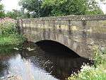 | |||
| Lochwinnoch Village 3 Braehead | 55°47′48″N 4°37′51″W | Category C(S) | 12649 | | |||
| Auchengrange House & Stables (Formerly Wattiston) | 55°46′55″N 4°35′57″W | Category B | 12660 | 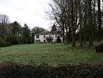 | |||
| Calderbank House | 55°48′17″N 4°38′01″W | Category C(S) | 12665 | | |||
| Lochwinnoch, 51 And 53 High Street, Lochwinnoch Community Library, Including Boundary Wall | 55°47′45″N 4°37′40″W | Category C(S) | 51733 | | |||
| Castle Semple Park, Cascades, Cave And Walled Garden | 55°48′27″N 4°35′34″W | Category B | 44828 | | |||
| 19 Johnshill | 55°47′58″N 4°37′26″W | Category C(S) | 13832 | | |||
| Calderbank Mill | 55°48′14″N 4°38′01″W | Category B | 12605 | | |||
| 5 Johnshill | 55°47′52″N 4°37′29″W | Category B | 12616 | | |||
| Main St, Calder House & Gatepiers | 55°47′37″N 4°37′54″W | Category C(S) | 12619 | | |||
| Low Beltrees Farm | 55°47′32″N 4°35′27″W | Category B | 12623 | | |||
| Lochwinnoch Village, Church Street, K6 Telephone Kiosk | 55°47′39″N 4°37′43″W | Category B | 12632 | | |||
| Castle Semple Warlock Gates | 55°48′35″N 4°36′39″W | Category B | 12636 | | |||
| East Gavin Farmhouse | 55°48′17″N 4°34′23″W | Category C(S) | 12639 | | |||
| Lochside House, Office Range To South West Of House | 55°47′28″N 4°36′30″W | Category C(S) | 12648 | | |||
| Boghead | 55°48′23″N 4°37′40″W | Category C(S) | 12662 | | |||
| Lochwinnoch Village Harvey Square Novar | 55°47′40″N 4°37′39″W | Category C(S) | 12607 | | |||
| 27 High Street | 55°47′43″N 4°37′44″W | Category B | 12610 | | |||
| 2, 4 High Street | 55°47′41″N 4°37′46″W | Category C(S) | 12613 | | |||
| 18, 20, 22 High Street | 55°47′42″N 4°37′44″W | Category C(S) | 12614 | | |||
| St Winnock's Church & Church Yard | 55°47′50″N 4°37′27″W | Category B | 12622 | 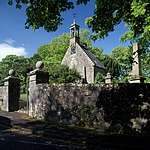 | |||
| Newton Of Beltrees Glenhead, Valley View And Calver's Cottage | 55°47′20″N 4°35′33″W | Category C(S) | 12628 | | |||
| Howood The Inn | 55°48′40″N 4°33′22″W | Category B | 12644 | | |||
| Lochside House | 55°47′29″N 4°36′29″W | Category B | 12647 | | |||
| Lochwinnoch Village Church Street Calder Uf Manse | 55°47′35″N 4°37′35″W | Category B | 12657 | | |||
| Caul Near To Bridgend Bridge | 55°47′59″N 4°38′10″W | Category B | 13052 | | |||
| Lochwinnoch Village, Bridgend, Bridge Over River Calder | 55°47′57″N 4°38′09″W | Category B | 12902 | | |||
| 29 High Street | 55°47′43″N 4°37′43″W | Category B | 12611 | | |||
| Main St Calderhaugh Mill | 55°47′37″N 4°37′58″W | Category B | 12620 | | |||
| Main St Calderhaugh House, Stables, Walled Garden And Gatepiers | 55°47′36″N 4°38′00″W | Category B | 12621 | | |||
| Lochwinnoch Village Church Street Parish Church And Hall | 55°47′38″N 4°37′43″W | Category A | 12654 | | |||
| Lochwinnoch Village Church Street Ladeside House | 55°47′35″N 4°37′37″W | Category B | 12655 | | |||
| Church Street Calder Uf Church And Hall, Gatepiers And Churchyard Wall | 55°47′35″N 4°37′36″W | Category B | 12656 | | |||
| Barr Castle | 55°47′18″N 4°38′17″W | Category B | 12661 | | |||
| Lochwinnoch, Largs Road, Saint Joseph's (Formerly Garthland) Including Chapel And Dormitory | 55°47′33″N 4°38′33″W | Category C(S) | 50473 | | |||
| Castle Semple Farmhouse And Walled Garden No 11 Holding | 55°48′44″N 4°35′20″W | Category B | 13835 | | |||
| Lochwinnoch, Earlshill Farm | 55°47′40″N 4°34′42″W | Category B | 13336 | | |||
| 79 High Street | 55°47′47″N 4°37′35″W | Category B | 12612 | | |||
| 42 High Street | 55°47′44″N 4°37′40″W | Category B | 12615 | | |||
| Newton Of Beltrees Glenshian | 55°47′19″N 4°35′32″W | Category B | 12627 | | |||
| Castle Semple West Gates And Gatepiers | 55°47′55″N 4°37′08″W | Category B | 12637 | | |||
| Clovenstone | 55°49′10″N 4°39′44″W | Category C(S) | 12638 | | |||
| Langslie | 55°46′30″N 4°39′28″W | Category C(S) | 12645 | | |||
| 4 Church Street | 55°47′41″N 4°37′46″W | Category C(S) | 12653 | | |||
| Castle Semple Ice House | 55°48′25″N 4°35′44″W | Category B | 12668 | | |||
| Harvey Square Ardmannoch | 55°47′40″N 4°37′38″W | Category C(S) | 12608 | | |||
| North Muir Dykes And Gatepiers | 55°48′04″N 4°34′02″W | Category C(S) | 12630 | | |||
| Castle Semple Railway Bridge | 55°48′06″N 4°36′25″W | Category B | 12635 | 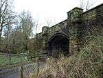 | |||
| Garthland Bridge Over Black Cart | 55°48′45″N 4°33′48″W | Category A | 12641 | | |||
| Lochwinnoch Village Calder Bridge Over River Calder | 55°47′28″N 4°37′33″W | Category B | 12650 | 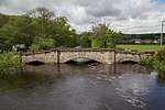 | |||
| Bourtrees Farm | 55°46′31″N 4°36′50″W | Category B | 12663 | | |||
| Castle Semple Former Mansion House | 55°48′25″N 4°35′26″W | Category B | 12666 | | |||
| Castle Semple Collegiate Church | 55°48′25″N 4°35′37″W | Category A | 12667 | | |||
| Lochwinnoch Village Burnfoot House | 55°47′45″N 4°38′15″W | Category B | 13834 | | |||
| Lochwinnoch Road, Ward Farm | 55°50′21″N 4°38′18″W | Category C(S) | 13482 | | |||
| Glenhead Farm House | 55°47′15″N 4°35′35″W | Category B | 12901 | | |||
| 6-10 Church Street | 55°47′41″N 4°37′46″W | Category C(S) | 12903 | | |||
| Lochwinnoch Village 23, 25 High Street | 55°47′43″N 4°37′44″W | Category B | 12609 | | |||
| Low Beltrees Farm Beltrees Private Burial Ground | 55°47′33″N 4°35′27″W | Category B | 12624 | | |||
| Moniabrock | 55°50′04″N 4°37′57″W | Category C(S) | 12625 | | |||
| Newton Of Beltrees Former School | 55°47′19″N 4°35′34″W | Category C(S) | 12629 | | |||
| South Fairhills | 55°47′45″N 4°39′21″W | Category C(S) | 12631 | | |||
| Castle Semple Ornamental Well | 55°48′33″N 4°35′32″W | Category C(S) | 12634 | | |||
| Lochwinnoch Village 17, 19 Church St (Former Courthouse And Police Station) | 55°47′40″N 4°37′44″W | Category C(S) | 12652 | | |||
| Lochwinnoch Village East End Manse | 55°47′58″N 4°37′18″W | Category B | 12659 | | |||
| 46 Main Street, Lochwinnoch | 55°47′39″N 4°37′53″W | Category C(S) | 13833 | | |||
| 14-16 (Inclusive Nos) Newton Of Barr | 55°47′34″N 4°38′06″W | Category C(S) | 13312 | | |||
| Johnshill Crookside | 55°48′00″N 4°37′27″W | Category B | 12617 | | |||
| Lochwinnoch Village 1 Main St/2 Church Street | 55°47′41″N 4°37′47″W | Category B | 12618 | | |||
| Howwood, Elliston Farm, Including Dutch Barn | 55°48′27″N 4°33′54″W | Category C(S) | 12640 | | |||
| 22 Calder St | 55°47′44″N 4°37′50″W | Category C(S) | 12651 | | |||
| East End Knapdale | 55°47′52″N 4°37′21″W | Category B | 12658 | |
Key
The scheme for classifying buildings in Scotland is:
- Category A: "buildings of national or international importance, either architectural or historic; or fine, little-altered examples of some particular period, style or building type."[1]
- Category B: "buildings of regional or more than local importance; or major examples of some particular period, style or building type, which may have been altered."[1]
- Category C: "buildings of local importance; lesser examples of any period, style, or building type, as originally constructed or moderately altered; and simple traditional buildings which group well with other listed buildings."[1]
In March 2016 there were 47,288 listed buildings in Scotland. Of these, 8% were Category A, and 50% were Category B, with the remaining 42% being Category C.[2]
Notes
- Sometimes known as OSGB36, the grid reference (where provided) is based on the British national grid reference system used by the Ordnance Survey.
• "Guide to National Grid". Ordnance Survey. Retrieved 2007-12-12.
• "Get-a-map". Ordnance Survey. Retrieved 2007-12-17. - Historic Environment Scotland assign a unique alphanumeric identifier to each designated site in Scotland, for listed buildings this always begins with "LB", for example "LB12345".
gollark: Of course not. Why would I do OOP?
gollark: `bad argument: table expected, got nil`
gollark: No.
gollark: Does it just convert *any* k in chat to krist?
gollark: `attempt to index a nil value`
References
- All entries, addresses and coordinates are based on data from Historic Scotland. This data falls under the Open Government Licence
- "What is Listing?". Historic Environment Scotland. Retrieved 29 May 2018.
- Scotland's Historic Environment Audit 2016 (PDF). Historic Environment Scotland and the Built Environment Forum Scotland. pp. 15–16. Retrieved 29 May 2018.
This article is issued from Wikipedia. The text is licensed under Creative Commons - Attribution - Sharealike. Additional terms may apply for the media files.