List of listed buildings in Erskine, Renfrewshire
List
| Name | Location | Date Listed | Grid Ref. [note 1] | Geo-coordinates | Notes | LB Number [note 2] | Image |
|---|---|---|---|---|---|---|---|
| Langbank, Main Street, Woodside Cottages Including Garden Walls And Gatepiers | 55°55′37″N 4°35′49″W | Category B | 43479 |  | |||
| Langbank, Middlepenny Road, St Vincent's College, Chapel | 55°55′32″N 4°35′36″W | Category B | 13631 | | |||
| Erskine House, Stable Court | 55°55′09″N 4°28′36″W | Category B | 12377 | 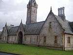 | |||
| Formakin House, Old Meal Mill Adjoining Bothy Block | 55°54′09″N 4°32′44″W | Category B | 12380 | 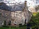 | |||
| Kennels At Erskine House | 55°55′04″N 4°28′34″W | Category B | 10892 | | |||
| Ritchieston Cottages | 55°54′53″N 4°30′12″W | Category C(S) | 10899 | | |||
| Gate-Lodge To Convent Of The Good Shepherd, Greenock Rd., Bishopton | 55°54′30″N 4°29′49″W | Category C(S) | 10902 | | |||
| Bothy Block With Attached Buildings, Formakin House | 55°54′10″N 4°32′42″W | Category B | 10905 | | |||
| Langbank, Middlepenny Road, St Vincent's College, Lodge | 55°55′33″N 4°35′38″W | Category C(S) | 13629 | | |||
| Erskine Hospital Ferry Lodge, By Erskine Ferry | 55°55′02″N 4°27′43″W | Category B | 12375 | 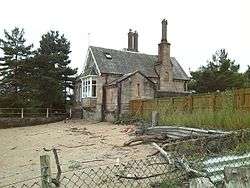 | |||
| Blantyre Monument By Freeland, Bishopton | 55°54′57″N 4°29′45″W | Category B | 10889 | | |||
| Ailsa Lodge (Former Manse) | 55°54′56″N 4°29′08″W | Category C(S) | 10893 | | |||
| Home Farm Steading A) Main Block B) West Block C) North Block | 55°55′06″N 4°29′41″W | Category B | 10895 | | |||
| Farm Cottage And Store At Erskine Home Farm | 55°55′02″N 4°29′41″W | Category C(S) | 10896 | | |||
| Golf Road, Dove Cottage | 55°55′11″N 4°30′19″W | Category B | 10900 | | |||
| Formakin House, By Bishopton | 55°54′20″N 4°32′43″W | Category A | 10903 | | |||
| Dargavel House, Royal Ordnance Factory, Bishopton | 55°53′27″N 4°30′25″W | Category B | 10908 | 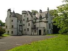 | |||
| Langbank, Middlepenny Road, St Vincent's College, (Former Langbank House) | 55°55′32″N 4°35′33″W | Category B | 13630 | | |||
| Erskine House, Pigsty At Stables | 55°55′08″N 4°28′34″W | Category B | 12378 | 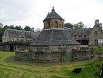 | |||
| Erskine Home Farmhouse | 55°55′05″N 4°29′40″W | Category C(S) | 12379 | | |||
| South Lodge Of Erskine Hospital,Freeland, Bishopton | 55°54′59″N 4°29′22″W | Category B | 10888 | | |||
| Old Bishopton House, Portion Of Convent Of The Good Shepherd, Greenock Road, Bishopton | 55°55′13″N 4°31′51″W | Category B | 10901 | | |||
| Bishopton, Mar Hall Drive, Mar Hall Hotel (Former Portion Of Erskine Hospital, Formerly Erskine House) | 55°55′15″N 4°28′44″W | Category A | 10909 | 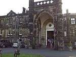 | |||
| House At Kennels, Erskine House | 55°55′04″N 4°28′33″W | Category B | 10891 | | |||
| Kirkton Cottages, Freeland, By Bishopton | 55°54′53″N 4°29′16″W | Category B | 10894 | | |||
| Offices At Freelands House | 55°55′09″N 4°29′42″W | Category C(S) | 10898 | | |||
| Main Entrance Gateway & Lodge, Formakin House | 55°54′21″N 4°32′41″W | Category B | 10904 | | |||
| Cottage At Walled Garden, Erskine House | 55°54′59″N 4°29′22″W | Category B | 10890 | | |||
| Gleddoch House, By Langbank | 55°55′06″N 4°35′06″W | Category B | 10906 | | |||
| East Lodge Of Finlaystone House, By Langbank | 55°55′38″N 4°36′14″W | Category B | 10907 | 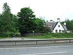 | |||
| Erskine Parish Church, Freeland By Bishoptown | 55°54′58″N 4°29′14″W | Category B | 10910 | | |||
| Bishopton, Rossland Church Of Scotland | 55°54′36″N 4°30′44″W | Category C(S) | 12376 | | |||
| Freelands House | 55°55′10″N 4°29′42″W | Category B | 10897 | |
Key
The scheme for classifying buildings in Scotland is:
- Category A: "buildings of national or international importance, either architectural or historic; or fine, little-altered examples of some particular period, style or building type."[1]
- Category B: "buildings of regional or more than local importance; or major examples of some particular period, style or building type, which may have been altered."[1]
- Category C: "buildings of local importance; lesser examples of any period, style, or building type, as originally constructed or moderately altered; and simple traditional buildings which group well with other listed buildings."[1]
In March 2016 there were 47,288 listed buildings in Scotland. Of these, 8% were Category A, and 50% were Category B, with the remaining 42% being Category C.[2]
Notes
- Sometimes known as OSGB36, the grid reference (where provided) is based on the British national grid reference system used by the Ordnance Survey.
• "Guide to National Grid". Ordnance Survey. Retrieved 2007-12-12.
• "Get-a-map". Ordnance Survey. Retrieved 2007-12-17. - Historic Environment Scotland assign a unique alphanumeric identifier to each designated site in Scotland, for listed buildings this always begins with "LB", for example "LB12345".
gollark: `systemctl enable --now syncthing@[user]`, assuming you're on a systemduous distribution, which you probably are.
gollark: It's not my fault if you're just bad at listening to my good, excellent advice.
gollark: Just use the service, utter.
gollark: This is just Macron but in hardware.
gollark: This is helpful, right?
References
- All entries, addresses and coordinates are based on data from Historic Scotland. This data falls under the Open Government Licence
- "What is Listing?". Historic Environment Scotland. Retrieved 29 May 2018.
- Scotland's Historic Environment Audit 2016 (PDF). Historic Environment Scotland and the Built Environment Forum Scotland. pp. 15–16. Retrieved 29 May 2018.
This article is issued from Wikipedia. The text is licensed under Creative Commons - Attribution - Sharealike. Additional terms may apply for the media files.