List of listed buildings in Kilbarchan, Renfrewshire
List
| Name | Location | Date Listed | Grid Ref. [note 1] | Geo-coordinates | Notes | LB Number [note 2] | Image |
|---|---|---|---|---|---|---|---|
| Bridge Of Weir, Clevans Road, Inchgarvie House | 55°51′14″N 4°35′17″W | Category B | 13051 |  | |||
| Bridge Of Weir, 12 And 12A Kilbarchan Road, Rockcliffe And Rockcliffe East | 55°51′11″N 4°34′17″W | Category B | 12958 | | |||
| 15 (Formerly 15, 17) Low Barholm, Kilbarchan | 55°50′01″N 4°32′42″W | Category B | 12829 | | |||
| 31 Low Barholm, Kilbarchan | 55°50′00″N 4°32′37″W | Category C(S) | 12832 | | |||
| Cartside Terrace, Waterside, By Johnstone | 55°49′48″N 4°32′05″W | Category B | 12835 | | |||
| 21-25 Steeple Street, Kilbarchan | 55°50′10″N 4°33′08″W | Category C(S) | 12840 | | |||
| "Greenways" Clevans Road And Donaldfield Road, Bridge Of Weir | 55°51′13″N 4°35′21″W | Category C(S) | 12769 | | |||
| 15, 17 Church Street, Kilbarchan | 55°50′08″N 4°33′14″W | Category C(S) | 12785 | | |||
| 9 Shuttle Street Yardshead Kilbarchan | 55°50′12″N 4°33′15″W | Category B | 12793 | | |||
| "Forehouse" Locher Road, Kilbarchan | 55°50′20″N 4°33′34″W | Category B | 12797 | 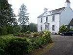 | |||
| Bridge Of Weir, Castle Terrace And 1-3 (Odd Nos) Prieston Road | 55°51′15″N 4°34′21″W | Category B | 12959 | 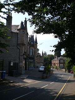 | |||
| 11-20 (All Numbers) Gateside Kilbarchan | 55°50′13″N 4°32′57″W | Category B | 12801 | | |||
| 10 The Cross, (Formerly "The Masons Arms") Kilbarchan | 55°50′10″N 4°33′13″W | Category B | 12806 | | |||
| 5 Low Barholm, Kilbarchan | 55°50′02″N 4°32′45″W | Category B | 12825 | | |||
| 19, 21 Low Barholm, Kilbarchan | 55°50′01″N 4°32′41″W | Category B | 12830 | | |||
| Waterstone Farm, Bridge Of Weir Road, By Brookfield | 55°50′44″N 4°32′51″W | Category C(S) | 12834 | | |||
| 1-6 Gryffe Place Main Street Bridge Of Weir | 55°51′28″N 4°34′49″W | Category B | 12760 | | |||
| 23 Church Street, Kilbarchan | 55°50′08″N 4°33′14″W | Category C(S) | 12786 | | |||
| 1-8 Gateside, Kilbarchan | 55°50′15″N 4°32′58″W | Category B | 12799 | | |||
| 14 Low Barholm, Kilbarchan | 55°50′01″N 4°32′42″W | Category C(S) | 12819 | | |||
| 27 Low Barholm, Kilbarchan | 55°50′00″N 4°32′38″W | Category C(S) | 12831 | | |||
| Clippens House, Clippens Road, By Linwood | 55°51′05″N 4°30′19″W | Category B | 12833 | | |||
| Kilbarchan Village Weaving Shop New Street Kilbarchan | 55°50′12″N 4°33′08″W | Category B | 12740 | | |||
| Weaving Shop (Now A Dwelling) Behind 37 Low Barholm Kilbarchan | 55°50′00″N 4°32′35″W | Category B | 12742 | | |||
| Torr Hall | 55°51′39″N 4°36′22″W | Category B | 12745 | 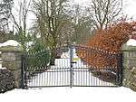 | |||
| "Homestead", Golf Course Road Bridge Of Weir | 55°51′20″N 4°35′19″W | Category C(S) | 12762 | | |||
| Lintwhite School Lintwhite Crescent | 55°51′21″N 4°34′28″W | Category B | 12773 | | |||
| Manswrae Farm Kilbarchan Road By Bridge Of Weir | 55°51′00″N 4°33′51″W | Category B | 12777 | | |||
| 11, (Formerly 9 And 11,) 13 Church Street Kilbarchan | 55°50′09″N 4°33′14″W | Category C(S) | 12784 | | |||
| Allan Memorial Fountain Church Street, Kilbarchan | 55°50′06″N 4°33′19″W | Category C(S) | 12789 | | |||
| Well Cottage, Shuttle Street, Kilbarchan | 55°50′17″N 4°33′24″W | Category C(S) | 12794 | | |||
| 30 New Street, Kilbarchan | 55°50′16″N 4°33′01″W | Category B | 12798 | | |||
| Bridge Of Weir, Kilbarchan Road, St Machar's Ranfurly Church (Church Of Scotland) With Lychgate And Boundary Walls | 55°51′14″N 4°34′15″W | Category B | 49075 | | |||
| 26 High Barholm, (Little Acre Forge) | 55°50′02″N 4°32′51″W | Category B | 12809 | | |||
| "Beltrees Cottage", High Barholm, Kilbarchan | 55°50′02″N 4°33′00″W | Category C(S) | 12810 | | |||
| 30 High Barholm, Kilbarchan | 55°50′02″N 4°32′51″W | Category C(S) | 12813 | | |||
| 34 High Barholm, Kilbarchan | 55°50′02″N 4°32′49″W | Category C(S) | 12815 | | |||
| 36 High Barholm, Kilbarchan | 55°50′02″N 4°32′49″W | Category C(S) | 12816 | | |||
| Weaving Shop Between 16 Steeple Street And The Old Manse Kilbarchan | 55°50′10″N 4°33′11″W | Category C(S) | 12744 | | |||
| Gryffe Inn, Main Street, Bridge Of Weir | 55°51′29″N 4°34′47″W | Category C(S) | 12757 | | |||
| "Dundarroch" Golf Course Road Bridge Of Weir | 55°51′19″N 4°35′17″W | Category B | 12761 | | |||
| "Brannochlie", Prieston Road, Bridge Of Weir | 55°51′15″N 4°34′50″W | Category B | 12771 | | |||
| Ranfurly Church Of Scotland Ranfurly Place Bridge Of Weir | 55°51′14″N 4°34′50″W | Category B | 12774 | | |||
| Barnbeth House By Bridge Of Weir (With Gates, Garden Walls And Ancillary Buildings) | 55°50′58″N 4°36′44″W | Category B | 12776 | | |||
| 35 Low Barholm, Kilbarchan | 55°50′00″N 4°32′36″W | Category C(S) | 12781 | | |||
| 41 Low Barholm, Kilbarchan | 55°49′59″N 4°32′34″W | Category C(S) | 12783 | | |||
| "Woodside" Merchant's Close, Kilbarchan | 55°50′09″N 4°33′20″W | Category C(S) | 12791 | | |||
| 29 Church Street, Kilbarchan | 55°50′07″N 4°33′16″W | Category C(S) | 13843 | | |||
| Kilbarchan Old Parish Church Of Scotland, Church Street | 55°50′09″N 4°33′17″W | Category B | 13468 | | |||
| Glentyan House, By Kilbarchan | 55°50′06″N 4°33′38″W | Category B | 12804 | | |||
| Wardhouse Forehouse Road Glentyan By Kilbarchan | 55°50′08″N 4°33′59″W | Category B | 12805 | | |||
| 29 High Barholm, Kilbarchan | 55°50′03″N 4°32′51″W | Category B | 12811 | | |||
| 31 High Barholm, Kilbarchan | 55°50′03″N 4°32′50″W | Category B | 12812 | | |||
| 6 Low Barholm, Kilbarchan | 55°50′01″N 4°32′45″W | Category B | 12817 | | |||
| 18 Low Barholm, Kilbarchan | 55°50′00″N 4°32′40″W | Category C(S) | 12820 | | |||
| 7 And 7A Low Barholm, Kilbarchan | 55°50′02″N 4°32′45″W | Category B | 12826 | | |||
| 13 Low Barholm, Kilbarchan | 55°50′01″N 4°32′42″W | Category B | 12828 | | |||
| "Threeplands" Golf Course Road Bridge Of Weir | 55°51′23″N 4°35′36″W | Category C(S) | 12768 | | |||
| "The Cairn", Prieston Road, Bridge Of Weir | 55°51′16″N 4°34′56″W | Category B | 12770 | | |||
| Bridge Of Weir, Ranfurly Castle Golf Clubhouse | 55°51′16″N 4°35′14″W | Category B | 12779 | | |||
| 39 Low Barholm, Kilbarchan | 55°50′00″N 4°32′34″W | Category C(S) | 12782 | | |||
| 5 Shuttle Street, Kilbarchan | 55°50′11″N 4°33′15″W | Category B | 12792 | | |||
| April Cottage 23 Shuttle Street Kilbarchan | 55°50′13″N 4°33′18″W | Category C(S) | 12795 | | |||
| 16 Low Barholm, Kilbarchan | 55°50′00″N 4°32′41″W | Category C(S) | 13844 | | |||
| Auchensale Ridge Over Locher Water At Harelaw Farm Road-End | 55°50′28″N 4°35′26″W | Category C(S) | 13050 | | |||
| 9-10 Gateside, Kilbarchan | 55°50′13″N 4°32′56″W | Category B | 12800 | | |||
| "The White House" Milliken | 55°50′31″N 4°31′47″W | Category B | 12802 | | |||
| 1, 3 Low Barholm, Kilbarchan | 55°50′02″N 4°32′45″W | Category B | 12824 | | |||
| "Tower House", Milliken Park Road, Kilbarchan | 55°49′45″N 4°32′16″W | Category C(S) | 12838 | | |||
| Kilbarchan Steeple And Steeple Buildings, Steeple Square, Kilbarchan | 55°50′10″N 4°33′06″W | Category A | 12839 | 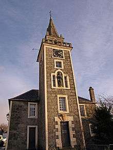 | |||
| 2, 4 Ewing Street, Kilbarchan | 55°50′09″N 4°33′05″W | Category B | 12841 | | |||
| East Parish Church, Steeple Square, Kilbarchan | 55°50′12″N 4°33′04″W | Category B | 12842 | | |||
| "Kincraig" Golf Course Road Bridge Of Weir | 55°51′22″N 4°35′32″W | Category C(S) | 12765 | | |||
| Auchenames Farm Kebbleston Road By Kilbarchan | 55°49′44″N 4°33′47″W | Category B | 12778 | | |||
| 25 Church Street, Kilbarchan | 55°50′07″N 4°33′15″W | Category C(S) | 12787 | | |||
| 27 Church Street, Kilbarchan | 55°50′07″N 4°33′15″W | Category C(S) | 12788 | | |||
| "The Cottage" (Formerly "Brookfield Cottage"), Shuttle Street/Locher Road | 55°50′15″N 4°33′24″W | Category C(S) | 12796 | | |||
| Garthland Bridge Over Black Cart Water; By Howwood | 55°48′45″N 4°33′48″W | Category A | 13842 | | |||
| 29 Low Barholm, Kilbarchan | 55°50′01″N 4°32′37″W | Category C(S) | 13845 | | |||
| 6 Steeple Street, Kilbarchan | 55°50′10″N 4°33′12″W | Category B | 12807 | | |||
| 8 And 10 Steeple Street, (Formerly 'The Black Bull'), Kilbarchan | 55°50′10″N 4°33′12″W | Category B | 12808 | | |||
| 24 Low Barholm, Kilbarchan | 55°50′00″N 4°32′39″W | Category C(S) | 12823 | | |||
| Glencart House, Milliken Park Road, Kilbarchan | 55°49′38″N 4°32′07″W | Category B | 12836 | | |||
| Weaver's Cottage, The Cross, Kilbarchan | 55°50′10″N 4°33′14″W | Category A | 12843 | 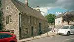 | |||
| St Bryde's House St Bryde's Road By Howwood | 55°48′49″N 4°34′48″W | Category C(S) | 12737 | | |||
| Bryde's Mill At St Bryde's | 55°48′50″N 4°34′52″W | Category B | 12738 | | |||
| 'Temple' On Kenmuir Hill By Castle Semple | 55°48′36″N 4°34′42″W | Category B | 12739 | | |||
| Weaving Shop Behind 3 Steeple Square Kilbarchan | 55°50′11″N 4°33′06″W | Category C(S) | 12741 | | |||
| Weaving Shop Behind 16 Ewing Street Kilbarchan | 55°50′07″N 4°33′03″W | Category C(S) | 12743 | | |||
| "Hermiston" Golf Course Road Bridge Of Weir | 55°51′21″N 4°35′25″W | Category B | 12763 | | |||
| "Greendykes" Golf Course Road Bridge Of Weir | 55°51′22″N 4°35′30″W | Category C(S) | 12764 | | |||
| Bridge Of Weir, Hazelwood Road, Beauly, Including Boundary Walls And Gatepiers | 55°51′03″N 4°34′35″W | Category B | 12772 | | |||
| "Easterhill" Bankend Road Northview Road Bridge Of Weir | 55°51′05″N 4°33′49″W | Category B | 12775 | | |||
| Former Parish Church, (Now Hall Of West Parish Church) Kilbarchan (Including Surrounding Churchyard) | 55°50′08″N 4°33′17″W | Category B | 12790 | | |||
| Bridge Of Weir Freeland Church | 55°51′24″N 4°34′39″W | Category C(S) | 13481 | 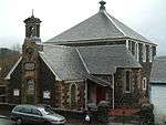 | |||
| Tower, Milliken | 55°50′20″N 4°31′36″W | Category C(S) | 12803 | | |||
| 32 High Barholm, Kilbarchan | 55°50′02″N 4°32′50″W | Category C(S) | 12814 | | |||
| 12 Low Barholm, Kilbarchan | 55°50′01″N 4°32′42″W | Category B | 12818 | | |||
| 20 Low Barholm, Kilbarchan | 55°50′00″N 4°32′40″W | Category C(S) | 12821 | | |||
| 22 Low Barholm, Kilbarchan | 55°50′00″N 4°32′39″W | Category C(S) | 12822 | | |||
| 11 Low Barholm, Kilbarchan | 55°50′01″N 4°32′43″W | Category B | 12827 | | |||
| "The Elms" Milliken Park Road, Kilbarchan | 55°49′44″N 4°32′13″W | Category C(S) | 12837 | | |||
| 14 Steeple Street, Kilbarchan Old Manse | 55°50′09″N 4°33′11″W | Category B | 12890 | | |||
| Bridge Of Weir, Main Street, 1 Morrison Place | 55°51′28″N 4°34′47″W | Category B | 12758 | | |||
| "Millwheel" Main Street Bridge Of Weir | 55°51′27″N 4°34′47″W | Category C(S) | 12759 | | |||
| 33 Low Barholm, Kilbarchan | 55°50′00″N 4°32′36″W | Category C(S) | 12780 | |
Key
The scheme for classifying buildings in Scotland is:
- Category A: "buildings of national or international importance, either architectural or historic; or fine, little-altered examples of some particular period, style or building type."[1]
- Category B: "buildings of regional or more than local importance; or major examples of some particular period, style or building type, which may have been altered."[1]
- Category C: "buildings of local importance; lesser examples of any period, style, or building type, as originally constructed or moderately altered; and simple traditional buildings which group well with other listed buildings."[1]
In March 2016 there were 47,288 listed buildings in Scotland. Of these, 8% were Category A, and 50% were Category B, with the remaining 42% being Category C.[2]
Notes
- Sometimes known as OSGB36, the grid reference (where provided) is based on the British national grid reference system used by the Ordnance Survey.
• "Guide to National Grid". Ordnance Survey. Retrieved 2007-12-12.
• "Get-a-map". Ordnance Survey. Retrieved 2007-12-17. - Historic Environment Scotland assign a unique alphanumeric identifier to each designated site in Scotland, for listed buildings this always begins with "LB", for example "LB12345".
gollark: It also claims to have read only 10TB and written 5TB, sooo...
gollark: ```Manufactured in week 18 of year 2012Specified cycle count over device lifetime: 10000Accumulated start-stop cycles: 1967Specified load-unload count over device lifetime: 300000Accumulated load-unload cycles: 1967Elements in grown defect list: 4```
gollark: (my server's HDD, I checked with `smartctl`)
gollark: "Manufactured in week 18 of year 2012"
gollark: I don't know how old it is exactly, but I kind of expect it to randomly fail at any moment.
References
- All entries, addresses and coordinates are based on data from Historic Scotland. This data falls under the Open Government Licence
- "What is Listing?". Historic Environment Scotland. Retrieved 29 May 2018.
- Scotland's Historic Environment Audit 2016 (PDF). Historic Environment Scotland and the Built Environment Forum Scotland. pp. 15–16. Retrieved 29 May 2018.
This article is issued from Wikipedia. The text is licensed under Creative Commons - Attribution - Sharealike. Additional terms may apply for the media files.