Letheringsett with Glandford
Letheringsett with Glandford is a civil parish in the English county of Norfolk. It includes the village of Letheringsett, along with the hamlet of Glandford.[2] The village straddles the A148 King’s Lynn to Cromer road. Letheringsett is 1.2 miles west of Holt, 32.2 west north east of King’s Lynn and 126 miles north north east of London. The nearest railway station is at Sheringham for the Bittern Line which runs between Sheringham, Cromer and Norwich.
| Letheringsett with Glandford | |
|---|---|
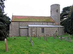 St Andrew's Parish Church, Letheringsett | |
 Village of Letheringsett about 1910 | |
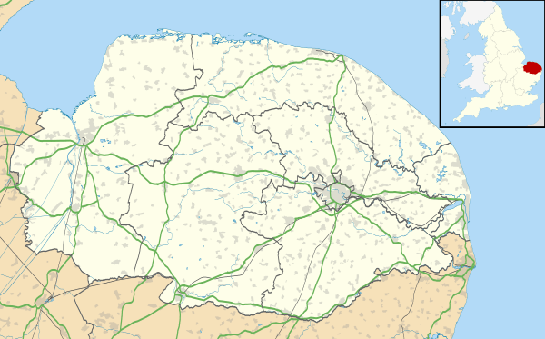 Letheringsett with Glandford Location within Norfolk | |
| Area | 8.19 km2 (3.16 sq mi) |
| Population | 232 (2011 census)[1] |
| • Density | 28/km2 (73/sq mi) |
| • London | 126 mi (203 km) |
| Civil parish |
|
| District | |
| Shire county | |
| Region | |
| Country | England |
| Sovereign state | United Kingdom |
| Post town | HOLT |
| Postcode district | NR25 |
| Dialling code | 01263 |
| Police | Norfolk |
| Fire | Norfolk |
| Ambulance | East of England |
| UK Parliament | |
Description
The north Norfolk parish of Letheringsett with Glandford were two separate parishes until amalgamated in the 20th century. Letheringsett’s name probably comes from the Old English for ‘Leodhere’s fold’, although, more attractively, the origins of the first part of the name may be from the Old English for sound or melody, perhaps alluding to the River Glaven. This latter interpretation is made doubly enticing by Glandford’s original meaning, ‘merriment ford’. In any event, both parishes have a long history and were certainly well established by the time of the Norman Conquest, their population, land ownership and productive resources being extensively detailed in the Domesday Book of 1086.[3]
History
The earliest evidence of human activity found in the archaeological record for the parish comes in the form of prehistoric, but otherwise undateable worked flint tools, but the oldest objects to which a definite date can be ascribed are Neolithic. Most of these are flint too, consisting of chipped axeheads, polished axeheads, a flake and a knife, but early pieces of Neolithic pottery have also been found to the west of Glandford.[4]
The Bronze Age has left tentative evidence of the earliest structures. While nothing can be seen on the ground, aerial photography has pinpointed several ring ditches, possibly the cropmarks of the surrounding ditches of long since ploughed-out burial mounds. Candlestick Hill to the west of the parish was once thought to be a Bronze Age barrow, but is now known to be a natural gravel feature. Finds from the period to date include copper alloy axeheads, a spearhead, rapiers and a chisel, another axehead and a flint scraper. Examples of Iron Age objects found so far include pottery fragments, a brooch and an Iceni gold coin.[5]
No evidence of structures remains from the period of the Roman occupation save for a roofing tile, but finds from the time are quite numerous. Selected examples include coins, brooches, pottery fragments, a pendant, nail cleaners, and a harness fitting.[6]
Pottery fragments from the Saxon period have been discovered, along with a number of brooches, a mount from a drinking horn and a very important Middle Saxon copper alloy mount for a book cover or a vessel, with a circular domed glass insert. A group of undated rectangular enclosures and features are visible as cropmarks on aerial photographs. The features may be geological in origin, but they could be Early Saxon sunken-featured buildings. Metal detecting to the east of Glandford in 2003 recovered an Early Saxon skillet. It was discovered that the skillet had been placed within an Early Saxon inhumation burial. The skeleton was of a male who was about 1.8m tall. As well as the skillet, he was accompanied by a spear, several pottery vessels, a knife, an iron-bound wooden bucket and two 5th or 6th century silver buckles.[7]
Medieval finds include coins, pottery fragments, brooches, seal matrices, part of a papal bull and a gold ring.[8]
The Midland and Great Northern Joint Railway North to South Line passed through the parish. This was the route of a 19th century railway from Norwich City Station to Cromer. To the east of Glandford is the site of a World War One airfield, which can be seen on 1946 aerial photographs.[9]
The proximity of the parish to the coast meant that it was incorporated into the massive anti-invasion construction programme carried out in World War Two. Most of these defensive structures were cleared away after the war, but survivals include two anti-tank mortar bases, a Home Guard shelter, rare Allan Williams turrets and a radio direction-finding post.[10]
Saint Andrew's Parish Church
The Saxon period has left the parish with its oldest surviving building, St Andrew’s church in Letheringsett. The round tower of this church is Late Saxon and features remnants of Late Saxon windows. The arcades are 13th century, the chancel dates to the 14th century and there is some 15th century stained glass. The 13th century font is made from Purbeck marble and the 19th century barrel organ was brought from Hindringham.[11] The church of Letheringsett, St Andrew's, is one of 124 existing round-tower churches in Norfolk. The church appears on a Royal Mail stamp issued on 21 June 1972 as part of a set on British Architecture (Village Churches).
Mills
Both Letheringsett and Glandford have the River Glaven running through them, and both have post medieval water mills on its course. Letheringsett Mill is a restored 19th century watermill. A mill stood on the site in 1720, but it burnt down and was rebuilt by 1754. The 1754 building also burnt down and the present building was erected in 1802. It was restored during the 1980s.The waterwheel and driving mechanism survive. To the north is Glavenside, a former mill house. It was built around 1800 and extended in 1902. Glandford Mill, marked on a map of 1797, has now been converted to residential use.[12]
Brewery
Letheringsett brewery was an important 18th and 19th century brewery and maltings complex. The surviving buildings stand around a courtyard and include a malthouse, a building containing two malt kilns, a tun house, cart sheds and Glaven Cottage, the brewer's house. Sections of the brewhouse remain, although most of it was demolished following a fire in 1936. The complex had a waterwheel which was located in a tunnel passing under the malthouse and the cart sheds.The brick and iron road bridge on the Holt to King's Lynn road was built as part of the complex in 1818. The Lily Pond was originally dug for use by the brewery, but also provided water to Letheringsett Hall. It was fed by a hydraulic ram in Letheringsett Park.[13]
Letheringsett Hall
Letheringsett Hall is a late 18th or early 19th century country house with associated buildings and structures. A set of 19th century stables incorporating a coach house and a dovecote stand close by. To the southwest is a 19th century pedestrian tunnel, which passes under the Holt to King's Lynn road. The landscape park associated with the house includes an orangery, a summer house, a water supply system and a fountain. It is a Grade II* listed building. A care home currently operates from the site.[14]
Notable people
- Jane Lead (1624–1704), a Christian mystic, was born at Letheringsett[15]
- John Burrell (1762–1825), entomologist and Rector of Letheringsett from 1786 to 1825
- Herbert Hardy Cozens-Hardy, 1st Baron Cozens-Hardy (1838-1920), Liberal politician and judge
- Mary Hardy (1733–1809), diarist
References
- "Civil Parish population 2011". Retrieved 31 August 2015.
- OS Explorer map 24” (Edition A 1997) – “Norfolk Coast Central. ISBN 0-319-21726-4.
- Aldridge, Piet (7 February 2007) http://www.heritage.norfolk.gov.uk/record-details?TNF1469-Letheringsett-with-Glandford-(Parish-Summary)
- Aldridge, Piet (7 February 2007) http://www.heritage.norfolk.gov.uk/record-details?TNF1469-Letheringsett-with-Glandford-(Parish-Summary)
- Aldridge, Piet (7 February 2007) http://www.heritage.norfolk.gov.uk/record-details?TNF1469-Letheringsett-with-Glandford-(Parish-Summary)
- Aldridge, Piet (7 February 2007) http://www.heritage.norfolk.gov.uk/record-details?TNF1469-Letheringsett-with-Glandford-(Parish-Summary)
- Aldridge, Piet (7 February 2007) http://www.heritage.norfolk.gov.uk/record-details?TNF1469-Letheringsett-with-Glandford-(Parish-Summary)
- Aldridge, Piet (7 February 2007) http://www.heritage.norfolk.gov.uk/record-details?TNF1469-Letheringsett-with-Glandford-(Parish-Summary)
- Aldridge, Piet (7 February 2007) http://www.heritage.norfolk.gov.uk/record-details?TNF1469-Letheringsett-with-Glandford-(Parish-Summary)
- Aldridge, Piet (7 February 2007) http://www.heritage.norfolk.gov.uk/record-details?TNF1469-Letheringsett-with-Glandford-(Parish-Summary)
- Aldridge, Piet (7 February 2007) http://www.heritage.norfolk.gov.uk/record-details?TNF1469-Letheringsett-with-Glandford-(Parish-Summary)
- Aldridge, Piet (7 February 2007) http://www.heritage.norfolk.gov.uk/record-details?TNF1469-Letheringsett-with-Glandford-(Parish-Summary)
- Aldridge, Piet (7 February 2007) http://www.heritage.norfolk.gov.uk/record-details?TNF1469-Letheringsett-with-Glandford-(Parish-Summary)
- Historic England. "Letheringsett Hall (Grade II*) (1049832)". National Heritage List for England. Retrieved 23 August 2017.
- Michael Martin, Literature and the Encounter with God in Post-Reformation England (2016), p. 156
External links
![]()
- Website with photos of Letheringsett St. Andrew, a round-tower church
- History of Letheringsett watermill