Lepreau Parish, New Brunswick
Lepreau is a civil parish in Charlotte County, New Brunswick, Canada,[2] west of Saint John. The Point Lepreau Nuclear Generating Station is located within the parish near its eastern border.
Lepreau Parish Paroisse de Lepreau | |
|---|---|
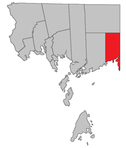 Location within Charlotte County. | |
| Country | |
| Province | |
| County | Charlotte |
| Established | 1857 |
| Government | |
| • Type | Local service district |
| Area | |
| • Land | 209.62 km2 (80.93 sq mi) |
| Population (2016) | |
| • Total | 707 |
| • Density | 3.4/km2 (9/sq mi) |
| • Pop 2011-2016 | |
| • Dwellings | 507 |
| Time zone | UTC-4 (AST) |
| • Summer (DST) | UTC-3 (ADT) |
The local service district (LSD) and Census subdivision of the same name have the same boundaries as the parish.[3]
The LSD assesses for basic services.[lower-alpha 1]
Origin of name
W.F. Ganong states that the name of the parish comes from Point Lepreau, the name being a corruption of French Pte. aux Napraux.[5]
The parish's name has varied in spelling - LePreau in 1857,[6] later Lepreaux,[7] and finally the modern spelling in 1973.[8]
History
Lepreau Parish was erected from Pennfield Parish in 1857.[6]
In 1868 all of the parish north of the southern point of Queens County was included in the Clarendon District, a polling district that also included the northern part of Pennfield Parish.[7] The Clarendon District was then erected as Clarendon Parish the next year[9] and Lepreau's modern boundaries were established.
Delineation
The entire parish can be found on New Brunswick Cadastral Map No. 163.[10]
Lepreau Parish is defined in the Territorial Division Act[2] as being bounded:
- West by Pennfield Parish; north by Clarendon Parish; east by the County line; and south by the Bay of Fundy, including Pocologan, New River and Salkeld Islands, and all other islands in front within two miles of the shore.
Communities
Communities that appear on provincial government maps.[11]
Bodies of water
Bodies of water that appear on provincial government maps.[11]
|
|
|
Islands
Islands that appear on provincial government maps.[11]
|
|
|
Conservation areas
Conservation areas that appear on provincial government maps.[11]
- Lepreau River Game Management Area
Census data
Population
| Canada census – Lepreau Parish, New Brunswick community profile | |||
|---|---|---|---|
| 2016 | 2011 | 2006 | |
| Population: | 708 (-6.0% from 2011) | 752 (-8.7% from 2006) | 824 (-4.7% from 2001) |
| Land area: | 209.62 km2 (80.93 sq mi) | 209.40 km2 (80.85 sq mi) | 209.40 km2 (80.85 sq mi) |
| Population density: | 3.4/km2 (8.8/sq mi) | 3.6/km2 (9.3/sq mi) | 3.9/km2 (10/sq mi) |
| Median age: | 53.0 (M: 51.3, F: 53.9) | 48.2 (M: 47.8, F: 48.5) | 46.8 (M: 46.1, F: 47.4) |
| Total private dwellings: | 507 | 510 | 490 |
| Median household income: | $57,216 | $42,747 | |
| References: 2016[12] 2011[13] 2006[14] earlier[15] | |||
|
|
| |||||||||||||||||||||||||||
| [16][1] | |||||||||||||||||||||||||||||
Language
| Canada Census Mother Tongue - Lepreau Parish, New Brunswick[16] | ||||||||||||||||||
|---|---|---|---|---|---|---|---|---|---|---|---|---|---|---|---|---|---|---|
| Census | Total | English |
French |
English & French |
Other | |||||||||||||
| Year | Responses | Count | Trend | Pop % | Count | Trend | Pop % | Count | Trend | Pop % | Count | Trend | Pop % | |||||
2011 |
750 |
720 | 96.00% | 20 | 2.67% | 0 | 0.00% | 10 | 1.33% | |||||||||
2006 |
820 |
790 | 96.34% | 20 | 2.44% | 0 | 0.00% | 10 | 1.22% | |||||||||
2001 |
870 |
835 | 95.98% | 25 | 2.87% | 0 | 0.00% | 10 | 1.15% | |||||||||
1996 |
875 |
855 | n/a | 97.71% | 10 | n/a | 1.14% | 0 | n/a | 0.00% | 10 | n/a | 1.14% | |||||
Access Routes
Highways and numbered routes that run through the parish, including external routes that start or finish at the parish limits:[17]
Notes
- Firefighting, policing, zoning, EMO, and dog control, along with administrative costs.[4]
References
- "Census Profile, 2016 Census Lepreau, Parish [Census subdivision], New Brunswick". Statistics Canada. Retrieved 1 September 2019.
- "Chapter T-3 Territorial Division Act". Government of New Brunswick. Retrieved 1 August 2020.
- "New Brunswick Regulation 84-168 under the Municipalities Act (O.C. 84-582)". Government of New Brunswick. Retrieved 1 August 2020.
- "2019 Local Government Statistics for New Brunswick" (PDF). Department of Environment and Local Government. p. 59. Retrieved 2 August 2020.
- Ganong, William F. (1896–97). "A Monograph of the Place-Nomenclature of the Province of New Brunswick". Transactions of the Royal Society of Canada. II: 244–245.CS1 maint: date format (link) Monograph is available as a free download from Canadiana.ca.
- Acts of the General Assembly of the Province of New Brunswick Passed in July 1856, and March and July 1857. Fredericton, New Brunswick: J. Simpson, Printer to the Queen's Most Excellent Majesty. 1857. p. 15. Book is available as a free download from Canadiana.ca and Google Books.
- Acts of the General Assembly of Her Majesty's Province of New Brunswick, passed in the month of April 1869. Fredericton, New Brunswick: G. E. Fenety, Printer to the Queen's Most Excellent Majesty. 1868. p. 84. Book is available as a free download from Google Books.
- "T-3 Territorial Division Act". Revised Statutes of New Brunswick. Government of New Brunswick. 1973. p. 14.
- Acts of the General Assembly of Her Majesty's Province of New Brunswick, passed in the month of April 1869. Fredericton, New Brunswick: G. E. Fenety, Printer to the Queen's Most Excellent Majesty. 1869. pp. 96–97. Book is available as a free download from Google Books.
- "No. 163". Provincial Archives of New Brunswick. Government of New Brunswick. Retrieved 3 August 2020.
- "471" (PDF). Province of New Brunswick. Retrieved 1 August 2020."482" (PDF). Province of New Brunswick. Retrieved 1 August 2020."492" (PDF). Province of New Brunswick. Retrieved 1 August 2020."499" (PDF). Province of New Brunswick. Retrieved 1 August 2020.
- "2016 Community Profiles". 2016 Canadian Census. Statistics Canada. 21 February 2017. Retrieved 1 September 2019.
- "2011 Community Profiles". 2011 Canadian Census. Statistics Canada. 5 July 2013. Retrieved 15 March 2014.
- "2006 Community Profiles". 2006 Canadian Census. Statistics Canada. 30 March 2011. Retrieved 15 March 2014.
- "2001 Community Profiles". 2001 Canadian Census. Statistics Canada. 17 February 2012.
- Statistics Canada: 1996, 2001, 2006, 2011 census
- Atlantic Canada Back Road Atlas ISBN 978-1-55368-618-7 Pages 4, 12
External links
Places adjacent to Lepreau Parish, New Brunswick | |
|---|---|
| Subdivisions |
|
|---|---|
| Cities | |
| Counties | |
| |