Le Pas
Le Pas is a commune in the Mayenne department in north-western France. Le Pas is a village located in the north of the Department of Mayenne. It is 10 km from Gorron, 42 km from Laval and 18 km from Mayenne.
Le Pas | |
|---|---|
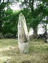 The Menhir of Saint Civière, in Le Pas | |
Location of Le Pas 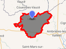
| |
 Le Pas  Le Pas | |
| Coordinates: 48°25′51″N 0°41′55″W | |
| Country | France |
| Region | Pays de la Loire |
| Department | Mayenne |
| Arrondissement | Mayenne |
| Canton | Gorron |
| Government | |
| • Mayor (2014–2020) | Martine Letissier |
| Area 1 | 21.90 km2 (8.46 sq mi) |
| Population (2017-01-01)[1] | 548 |
| • Density | 25/km2 (65/sq mi) |
| Time zone | UTC+01:00 (CET) |
| • Summer (DST) | UTC+02:00 (CEST) |
| INSEE/Postal code | 53176 /53300 |
| Elevation | 98–190 m (322–623 ft) (avg. 95 m or 312 ft) |
| 1 French Land Register data, which excludes lakes, ponds, glaciers > 1 km2 (0.386 sq mi or 247 acres) and river estuaries. | |
The village was liberated by American soldiers on 6 August 1944; a fact which is recorded at the war memorial.
Sites of interest
The menhir of Saint-Civière is a historic monument.
The church of St. Martin, was dedicated on October 8, 1787 and has two bells named Renee and Magdelaine.
Nearest settlements
Neighbouring localities. | |
|---|---|
gollark: Pretty hard.
gollark: Also, situations when you're right but the compiler can't prove it occasionally happen.
gollark: It can be kind of painful sometimes. My main issue is just compile times and in some cases poor type errors.
gollark: !quote 746717745122639964
gollark: Rust, of course, has no GC in the stdlib whatsoever.
See also
- Communes of Mayenne
| Wikimedia Commons has media related to Le Pas (Mayenne). |
| Authority control |
|
|---|
- "Populations légales 2017". INSEE. Retrieved 6 January 2020.
This article is issued from Wikipedia. The text is licensed under Creative Commons - Attribution - Sharealike. Additional terms may apply for the media files.