Méral
Méral is a commune in the Mayenne department in north-western France.
Méral | |
|---|---|
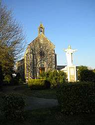 The Chapel of the Saint, in Méral | |
 Coat of arms | |
Location of Méral 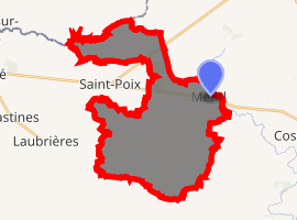
| |
 Méral  Méral | |
| Coordinates: 47°57′41″N 0°58′46″W | |
| Country | France |
| Region | Pays de la Loire |
| Department | Mayenne |
| Arrondissement | Château-Gontier |
| Canton | Cossé-le-Vivien |
| Government | |
| • Mayor (2008–2014) | Jean-Marc Foucher |
| Area 1 | 29.5 km2 (11.4 sq mi) |
| Population (2017-01-01)[1] | 1,098 |
| • Density | 37/km2 (96/sq mi) |
| Time zone | UTC+01:00 (CET) |
| • Summer (DST) | UTC+02:00 (CEST) |
| INSEE/Postal code | 53151 /53230 |
| Elevation | 59–102 m (194–335 ft) (avg. 95 m or 312 ft) |
| 1 French Land Register data, which excludes lakes, ponds, glaciers > 1 km2 (0.386 sq mi or 247 acres) and river estuaries. | |
Geography
The Oudon River forms part of the commune's north-eastern border.
gollark: Would you like me to add an option to skynet to download the JSON library somewhere else?
gollark: Oh, and now it stack-overflow-errors...
gollark: It's still running. I think I broke it, since it seems to be processing the same stuff repeatedly.
gollark: Now to get an advanced monitor and put that in green text...
gollark: Amazingly, dumping the entirety of CC's environment works fine! Until serializing it crashes...
See also
- Communes of Mayenne
References
- "Populations légales 2017". INSEE. Retrieved 6 January 2020.
External links
| Wikimedia Commons has media related to Méral. |
| Authority control |
|
|---|
This article is issued from Wikipedia. The text is licensed under Creative Commons - Attribution - Sharealike. Additional terms may apply for the media files.