Arrondissement of Mayenne
The arrondissement of Mayenne is an arrondissement of France in the Mayenne department in the Pays de la Loire region. It has 132 communes.[1] Its population is 120,982 (2016), and its area is 2,961.8 km2 (1,143.6 sq mi).[2]
Mayenne | |
|---|---|
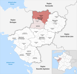 Location within the region Pays de la Loire | |
| Country | France |
| Region | Pays de la Loire |
| Department | Mayenne |
| No. of communes | 132 |
| Subprefecture | Mayenne |
| Area | |
| • Total | 2,961.8 km2 (1,143.6 sq mi) |
| Population (2016) | |
| • Total | 120,982 |
| • Density | 41/km2 (110/sq mi) |
| INSEE code | 533 |
Composition
The communes of the arrondissement of Mayenne, and their INSEE codes, are:[1]
- Alexain (53002)
- Ambrières-les-Vallées (53003)
- Andouillé (53005)
- Aron (53008)
- Assé-le-Bérenger (53010)
- Averton (53013)
- La Baconnière (53015)
- Bais (53016)
- La Bazoge-Montpinçon (53021)
- La Bazouge-des-Alleux (53023)
- Belgeard (53028)
- La Bigottière (53031)
- Blandouet-Saint Jean (53228)
- Boulay-les-Ifs (53038)
- Brecé (53042)
- Brée (53043)
- Carelles (53047)
- Chailland (53048)
- Champéon (53051)
- Champfrémont (53052)
- Champgenéteux (53053)
- Chantrigné (53055)
- La Chapelle-au-Riboul (53057)
- La Chapelle-Rainsouin (53059)
- Charchigné (53061)
- Châtillon-sur-Colmont (53064)
- Chevaigné-du-Maine (53069)
- Colombiers-du-Plessis (53071)
- Commer (53072)
- Contest (53074)
- Couesmes-Vaucé (53079)
- Couptrain (53080)
- Courcité (53083)
- Crennes-sur-Fraubée (53085)
- La Croixille (53086)
- Désertines (53091)
- La Dorée (53093)
- Ernée (53096)
- Évron (53097)
- Fougerolles-du-Plessis (53100)
- Gesnes (53105)
- Gesvres (53106)
- Gorron (53107)
- Grazay (53109)
- La Haie-Traversaine (53111)
- Le Ham (53112)
- Hambers (53113)
- Hardanges (53114)
- Hercé (53115)
- Le Horps (53116)
- Le Housseau-Brétignolles (53118)
- Izé (53120)
- Javron-les-Chapelles (53121)
- Jublains (53122)
- Juvigné (53123)
- Landivy (53125)
- Larchamp (53126)
- Lassay-les-Châteaux (53127)
- Lesbois (53131)
- Levaré (53132)
- Lignières-Orgères (53133)
- Livet (53134)
- Loupfougères (53139)
- Madré (53142)
- Marcillé-la-Ville (53144)
- Martigné-sur-Mayenne (53146)
- Mayenne (53147)
- Mézangers (53153)
- Montaudin (53154)
- Montenay (53155)
- Montreuil-Poulay (53160)
- Montsûrs (53161)
- Moulay (53162)
- Neau (53163)
- Neuilly-le-Vendin (53164)
- Oisseau (53170)
- La Pallu (53173)
- Parigné-sur-Braye (53174)
- Le Pas (53176)
- La Pellerine (53177)
- Placé (53179)
- Pontmain (53181)
- Pré-en-Pail-Saint-Samson (53185)
- Ravigny (53187)
- Rennes-en-Grenouilles (53189)
- Le Ribay (53190)
- Sacé (53195)
- Saint-Aignan-de-Couptrain (53196)
- Saint-Aubin-du-Désert (53198)
- Saint-Aubin-Fosse-Louvain (53199)
- Saint-Baudelle (53200)
- Saint-Berthevin-la-Tannière (53202)
- Saint-Calais-du-Désert (53204)
- Saint-Cyr-en-Pail (53208)
- Saint-Denis-de-Gastines (53211)
- Sainte-Gemmes-le-Robert (53218)
- Saint-Ellier-du-Maine (53213)
- Sainte-Marie-du-Bois (53235)
- Sainte-Suzanne-et-Chammes (53255)
- Saint-Fraimbault-de-Prières (53216)
- Saint-Georges-Buttavent (53219)
- Saint-Georges-le-Fléchard (53220)
- Saint-Georges-sur-Erve (53221)
- Saint-Germain-d'Anxure (53222)
- Saint-Germain-de-Coulamer (53223)
- Saint-Germain-le-Guillaume (53225)
- Saint-Hilaire-du-Maine (53226)
- Saint-Julien-du-Terroux (53230)
- Saint-Léger (53232)
- Saint-Loup-du-Gast (53234)
- Saint-Mars-du-Désert (53236)
- Saint-Mars-sur-Colmont (53237)
- Saint-Mars-sur-la-Futaie (53238)
- Saint-Martin-de-Connée (53239)
- Saint-Pierre-des-Landes (53245)
- Saint-Pierre-des-Nids (53246)
- Saint-Pierre-sur-Erve (53248)
- Saint-Pierre-sur-Orthe (53249)
- Saint-Thomas-de-Courceriers (53256)
- Saulges (53257)
- Soucé (53261)
- Thorigné-en-Charnie (53264)
- Thubœuf (53263)
- Torcé-Viviers-en-Charnie (53265)
- Trans (53266)
- Vaiges (53267)
- Vautorte (53269)
- Vieuvy (53270)
- Villaines-la-Juhel (53271)
- Villepail (53272)
- Vimarcé (53274)
- Voutré (53276)
History
The arrondissement of Mayenne was created in 1800.[3] At the March 2016 reorganisation of the arrondissements of Mayenne, it gained 38 communes from the arrondissement of Laval.[4]
As a result of the reorganisation of the cantons of France which came into effect in 2015, the borders of the cantons are no longer related to the borders of the arrondissements. The cantons of the arrondissement of Mayenne were, as of January 2015:[5]
- Ambrières-les-Vallées
- Bais
- Couptrain
- Ernée
- Gorron
- Le Horps
- Landivy
- Lassay-les-Châteaux
- Mayenne-Est
- Mayenne-Ouest
- Pré-en-Pail
- Villaines-la-Juhel
gollark: LOL -> LOL Out Loud -> LOL Out Loud Out Loud -> ...
gollark: IRL: "Iguanas Rapidly Leaving".
gollark: Honestly, that's basic interweb knowledge.
gollark: LOL is "LOL out loud"
gollark: BRB, by the way, is "Buy Red Bananas".
References
- "Arrondissement de Mayenne (533)". INSEE. Retrieved 2019-10-01.
- "Comparateur de territoire, géographie au 01/01/2019". INSEE. Retrieved 2019-10-01.
- Historique de la Mayenne
- "Arrêté préfectoral, 24 March 2016" (PDF). Retrieved 2019-10-22.
- "Populations légales 2012" (PDF). INSEE. December 2014. Retrieved 2019-10-22.
This article is issued from Wikipedia. The text is licensed under Creative Commons - Attribution - Sharealike. Additional terms may apply for the media files.