Landsend Peak
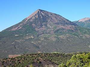
Landsend Peak is a prominent wedge-shaped mountain located in the West Elk Mountains range northeast of Crawford, Colorado. The summit of Landsend Peak has an elevation of 10,806 ft (3,294 m) rising dramatically about 4,000 ft (1,200 m) above the valley below.[1] Together with nearby Mount Lamborn to the northeast (the highest point in Delta County), it delineates the western edge of the West Elk Mountains (and West Elk Wilderness), and the two massifs top out about 1 mile (1.6 km) higher than the adjacent North Fork Gunnison River.[1] Both peaks lie within the Gunnison National Forest near the physiographic boundary of the Rocky Mountains and the Colorado Plateau provinces. Geologically, Landsend Peak and Mount Lamborn are exposed igneous intrusions that geologists call laccoliths.[4]
| Landsend Peak | |
|---|---|
 | |
| Highest point | |
| Elevation | 10,806 ft (3,294 m) [1] |
| Prominence | 1,286 ft (392 m) [2] |
| Isolation | 2.38 mi (3.83 km) [2] |
| Coordinates | 38°46′15″N 107°33′06″W [3] |
| Geography | |
 Landsend Peak | |
| Location | Delta County, Colorado, United States[3] |
| Parent range | West Elk Mountains[2] |
| Topo map | USGS 7.5' topographic map Paonia, Colorado |
References
- "Landsend Peak, Colorado". Topozone.com. Retrieved 27 July 2019.
- "Landsend Peak, Colorado". Peakbagger.com. Retrieved July 27, 2019.
- "Landsend Peak". Geographic Names Information System. United States Geological Survey. Retrieved July 27, 2019.
- "Noe, David C.,2015, Geologic Map of the Paonia Quadrangle, Delta County, Colorado. 1:24,000. Open File Report OF-15-07". Colorado Geological Survey. Retrieved 27 July 2019.
External links