Kamchatka Oblast (Russian Empire)
Kamchatka Oblast was the administrative-territorial unit of the Russian Empire.
Kamchatka Oblast Камчатская область | |
|---|---|
.jpg) Coat of arms | |
 | |
| Country | Russia |
| Political status | Oblast |
| Established | 1803 |

For the first time the Kamchatka Oblast as part of the Irkutsk governorate was formed on August 23, 1803. The center of the Oblast was appointed Verkhne-Kamchatsk, on April 21, 1812, the administration of the region was transferred to Petropavlovsk harbor. In 1822 the Oblast was abolished. Instead, in the Irkutsk Governorate, the Kamchatka Maritime Administration was established with its center in Petropavlovsk.
In 1849, the Kamchatka Oblast was re-established from the Kamchatka Maritime Administration and the Gizhiginsky District of the Okhotsk Maritime Administration. However, already in 1856, the Kamchatka Oblast was abolished, and its territory became part of the Primorskaya Oblast.
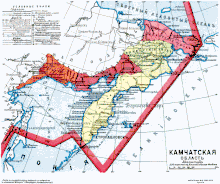
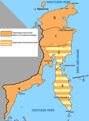
By the law of June 30, 1909, the Kamchatka Oblast was created for the third time. The Oblast included Petropavlovsk, Okhotsk, Gizhiginsky, Anadyr Uyezds and the Commander Islands, separated from the Primorskaya Oblast. At the same time, in the territory of Chukotka (part of the Anadyr Uyezd) the Chukotka Uyezd was formed. In 1922, the Kamchatka Oblast was transformed into the Kamchatka Governorate[1].
Coat of arms description
"In the silver shield there are three knolls or black fire-breathing mountains (middle one in front of the other two) with a scarlet flame and smoke above them. The shield is crowned with the ancient royal crown and is surrounded by golden oak leaves, connected by the Alexander Ribbon".

Population
According to the census of 1897, the population of the Kamchatka Oblast is sparse in numbers, which is also indicated by the population density, the Commander district is clearly distinguished among the general districts, in which the average population density is 10 times more.
The population of the districts of the Kamchatka Oblast for 1897[2]:
| District | Area, square versts | Area, square kilometers | Density, person per square kilometer | Men | Women | Total |
|---|---|---|---|---|---|---|
| Anadyr | 458 476,6 | 521 774,91 | 0,02 | 5 941 | 6 143 | 12 084 |
| Gizhiginsky | 185 347,7 | 210 937,22 | 0,04 | 3 837 | 3 655 | 7 492 |
| Commander | 1 524,0 | 1 734,41 | 0,38 | 322 | 329 | 651 |
| Okhotsk | 158 365,4 | 180 229,68 | 0,03 | 2 394 | 2 338 | 4 732 |
| Petropavlovsk | 339 697,1 | 386 596,44 | 0,02 | 4 241 | 4 124 | 8 365 |
| Kamchatka Oblast | 1 143 411 | 1 301 272,66 | 0,03 | 16 735 | 16 589 | 33 324 |
Oblast administration
1st period (1803–1822)
- Rulers
| Name | Title or rank | Time of filling the post |
|---|---|---|
| Pavel Koshelev | Major general | August 11, 1803 – November 14, 1806 |
| Ivan Petrovsky | Major general | November 14, 1806 – January 23, 1813 |
| Ilya Rudakov | Lieutenant | January 23, 1813 – May 1817 |
| Peter Ricord | Captain 1st rank | May 1817 – 1822 |
2nd period (1849–1856)
- Military Governor
| Name | Title or rank | Time of filling the post |
|---|---|---|
| Vasily Zavoyko | Counter admiral | December 2, 1849 – October 31, 1856 |
3rd period (1909–1922)
- Governors
| Name | Title or rank | Time of filling the post |
|---|---|---|
| Vasily Perfilyev | Active State Councillor | July 22, 1909 – June 18, 1912 |
| Nikolay Monomahov | Active State Councillor | June 18, 1912 – 1917 |
- Vice Governors
| Name | Title or rank | Time of filling the post |
|---|---|---|
| Evgeny Bodungen | Collegiate Assessor | July 8, 1909 – 1913 |
| Alexander Chaplinsky | Active State Councillor | 1914–1917 |
References
- Alexander Piragis (June 30, 2007). "Changes in the administrative subordination of Kamchatka for 310 years since its accession to Russia (1697–2007)". Piragis.ru.
- "First General Census of the Russian Empire in 1897. The existing population in the provinces, counties, cities of the Russian Empire (without Finland)".