Kétou, Benin
Kétou is a Yoruba town, arrondissement, and commune located in the Plateau Department of the Republic of Benin (previously called 'Dahomey'). The commune covers an area of 2183 square kilometres and as of 2013 had a population of 156,497 people,[1][2] making it the 13th largest settlement in Benin.[3]
Kétou | |
|---|---|
.jpg) Chief of Kétou (1900) | |
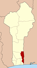
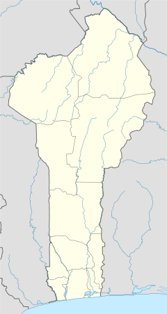 Kétou Location in Benin | |
| Coordinates: 7°21′29″N 2°36′27″E | |
| Country | |
| Department | Plateau Department |
| Area | |
| • Total | 843 sq mi (2,183 km2) |
| Population (2013) | |
| • Total | 156,497 (2,013) |
| Time zone | UTC+1 (WAT) |
History
Kétou (Ketu) is said to have been founded by Ede, son of Sopasan and grandson of Oduduwa (also known as Odudua, Oòdua and Eleduwa), who ruled the Yoruba kingdom of Ile-Ife (also known as Ife) in present-day Nigeria. The oba (meaning 'king' or 'ruler' in the Yoruba language) is referred to as the Alaketu of Ketu.
gollark: * μhahahaha
gollark: Idea: osmarks.net certificate authority?
gollark: It's not like there's *actually* a filesize limit, the container will have an internet connection.
gollark: It's several years old at this point right?
gollark: I like the *idea* of matrix, but the software seems somewhat apiomemetic right now.
References
| Wikivoyage has a travel guide for Kétou. |
- "Ketou". Atlas Monographique des Communes du Benin. Retrieved January 5, 2010.
- "Communes of Benin". Statoids. Archived from the original on March 24, 2012. Retrieved January 5, 2010.
- "Archived copy". Archived from the original on 2016-08-28. Retrieved 2016-11-15.CS1 maint: archived copy as title (link)
This article is issued from Wikipedia. The text is licensed under Creative Commons - Attribution - Sharealike. Additional terms may apply for the media files.