Hurricane Gert (2017)
Hurricane Gert was a strong tropical cyclone that brought heavy surf and rip currents to the East Coast of the United States in August 2017. Gert originated from a tropical wave that moved off the coast of Africa on August 3 yet failed to organize significantly until August 12, when the system coalesced into a tropical depression east of the Bahamas. A few hours later, the depression became the seventh tropical storm of the annual hurricane season and was named Gert. For the next day, though, further intensification was hindered by the proximity of dry air. Once Gert was able to overcome that on August 14, however, Gert resumed strengthening while moving northwards, paralleling the United States coastline. Gert reached its peak intensity on August 16 at Category 2 status on the Saffir–Simpson scale as it accelerated northeastwards. Thereafter, increasing vertical wind shear and decreasing sea surface temperatures caused Gert to rapidly weaken and transition into an extratropical cyclone on August 17, well east of Atlantic Canada. The remnants of Gert dissipated late on August 18, after they merged with another extratropical cyclone over the open Atlantic.
| Category 2 hurricane (SSHWS/NWS) | |
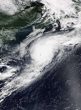
 Hurricane Gert at peak intensity south of Nova Scotia on August 16 | |
| Formed | August 12, 2017 |
|---|---|
| Dissipated | August 18, 2017 |
| (Extratropical after August 17) | |
| Highest winds | 1-minute sustained: 110 mph (175 km/h) |
| Lowest pressure | 962 mbar (hPa); 28.41 inHg |
| Fatalities | 2 total |
| Damage | Minimal |
| Areas affected | Eastern United States, Eastern Canada, Ireland, United Kingdom |
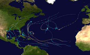
| Part of the 2017 Atlantic hurricane season | |
During its lifetime, Gert brought heavy swells, rough surf, and rip currents to the East Coast of the United States and Atlantic Canada. Two fatalities occurred when two swimmers drowned amid heavy surf. The extratropical system that merged with the remnants of Gert went on to bring strong winds and rain to Ireland and parts of the United Kingdom.
Meteorological history

On August 2, the National Hurricane Center (NHC) began to track a tropical wave over western Africa.[1] The wave emerged over the Atlantic Ocean on August 3, accompanied by a weak surface low-pressure area.[2] While moving quickly westwards south of Cape Verde in a generally favorable environment characterized by high sea surface temperatures (SSTs) and low vertical wind shear, the wave showed some signs of development, and was given a high chance of consolidating into a tropical depression during the next five days by the NHC.[3] However, by August 5, the system's swift movement brought it into less favorable conditions, causing most of the wave's associated showers and thunderstorms to dissipate. The wave continued to track westwards over the next few days, eventually splitting into two systems—the northern one being the precursor to Gert, and the southern portion later spawning Hurricane Kenneth in the Eastern Pacific.[2]
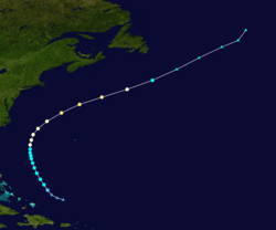
Afterwards, the precursor to Gert moved west-northwestwards, passing north of Puerto Rico on August 11.[4] As it did so, convective bands associated with the system began to curve and concentrate towards the center of the system, evidencing increasing organization. A surface low-pressure area developed on August 12, and a tropical depression formed at 18:00 UTC that same day 265 miles (425 km) northeast of the Turks and Caicos Islands. The depression organized further to become a tropical storm at 00:00 UTC on August 13, bearing maximum sustained winds of 40 mph (65 km/h), and received the name Gert.[2] Although conditions generally favored further intensification, with high SSTs and low wind shear, mid-level dry air disrupted Gert's central convection, causing Gert's intensity to hold steady for the next 18 hours. However, by August 14, Gert's circulation had mixed out the dry air, poising the storm for further strengthening.[2] At that time, Gert was moving north-northwestwards to northwards through a gap in the subtropical ridge.[5]

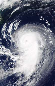
From August 14 onwards, Gert strengthened markedly, developing persistent deep convection and a central dense overcast. At 06:00 UTC on August 15, Gert became the second hurricane of the 2017 Atlantic hurricane season as sustained winds rose to 75 mph (120 km/h).[2] While an approaching mid-latitude trough began to accelerate Gert towards the northeast, Gert continued to intensify, developing an eye just 10 nautical miles (12 mi; 19 km) across. At 18:00 UTC on August 16, Gert reached its peak intensity with winds of 110 mph (175 km/h) and a minimum central pressure of 962 mbar (hPa; 28.41 inHg), ranked as Category 2 on the Saffir–Simpson scale.[2] Racing off to the east-northeast, Gert soon passed beyond the northern wall of the Gulf Stream, marking a significant decrease in SSTs. Compounded by increasing vertical wind shear and drier air,[6] Gert began to weaken and its cloud pattern rapidly deteriorated; the system degraded to a tropical storm by 12:00 UTC on August 17. Six hours later, Gert transitioned into an extratropical cyclone 335 miles (535 km) southeast of St. John's, Newfoundland. The weakening cyclone continued northeast over the open Atlantic Ocean, before dissipating by 00:00 UTC on August 19.[2] The remnant energy and moisture of the system merged with another extratropical cyclone to the northwest, which later went on to affect Ireland and the United Kingdom.[7]
Preparations and impact
While Gert did not approach any land areas during its lifetime as a tropical cyclone, Gert still generated heavy swells, rough surf, and rip currents along the East Coast of the United States and Atlantic Canada.[8] At Nantucket, Massachusetts, several beaches were closed,[9] and lifeguards conducted more than 25 water rescues on August 16 alone.[10] Despite this, a 40-year-old man drowned off Nobadeer Beach around noon on August 16; attempts to revive him with cardiopulmonary resuscitation after he was pulled from the water were not successful.[9][11] In the Outer Banks off Cape Hatteras National Seashore, a 63-year-old man drowned on August 14 after being caught in a rip current during an attempt to rescue another swimmer "in distress". The other swimmer later returned safely to shore.[12]
The remnants of Gert merged with another extratropical cyclone that produced strong winds and heavy rain in Ireland and the United Kingdom.[7] Ahead of the storm, Met Éireann issued yellow weather warnings for the entirety of Ireland, expecting heavy showers and localized flooding.[13] As the storm hit, severe floods occurred in Northern Ireland, with floodwaters reaching 1.5 m (4 ft 11 in). More than 100 people were rescued after being trapped in their cars or houses overnight.[14]
See also
- Other tropical cyclones named Gert
- Hurricane Alex (2004) – Category 3 hurricane that took a similar path.
- Hurricane Danielle (2010) – also caused large swells along the East Coast of the United States.
- Hurricane Chris (2018) – Hurricane of similar intensity that caused enhanced surf and swells along the United States East Coast.
References
- Eric S. Blake (August 2, 2017). "Five-Day Graphical Tropical Weather Outlook". Miami, Florida: National Hurricane Center. Retrieved April 8, 2018.
- Stacy R. Stewart (March 17, 2018). Hurricane Gert (PDF) (Report). Tropical Cyclone Report. Miami, Florida: National Hurricane Center. Archived from the original (PDF) on April 11, 2018. Retrieved April 8, 2017.
- Robbie J. Berg (August 4, 2017). "Five-Day Graphical Tropical Weather Outlook". Miami, Florida: National Hurricane Center. Retrieved April 8, 2018.
- Lixion A. Avila (August 11, 2017). "Five-Day Graphical Tropical Weather Outlook". Miami, Florida: National Hurricane Center. Retrieved April 8, 2018.
- Stacy R. Stewart (August 14, 2017). Tropical Storm Gert Discussion Number 6 (Report). Miami, Florida: National Hurricane Center. Retrieved April 8, 2018.
- John P. Cangialosi (August 17, 2017). Hurricane Gert Discussion Number 18 (Report). Miami, Florida: National Hurricane Center. Retrieved April 8, 2018.
- Linda Lam (August 23, 2017). "Remnants of Hurricane Gert Made It All the Way to Ireland, United Kingdom". The Weather Channel. Retrieved April 8, 2018.
- "Hurricane Gert Was a Wave Generator For US and Canada East Coasts (RECAP)". The Weather Channel. August 17, 2017. Retrieved April 8, 2018.
- Peter Sutters (August 17, 2017). "Man drowns in heavy surf off Nobadeer Wednesday". The Inquirer and Mirror. Retrieved April 8, 2018.
- Ada Carr (August 16, 2017). "Hurricane Gert Whips Up Strong Waves Off East Coast; 1 Dead in Massachusetts". The Weather Channel. Retrieved April 8, 2018.
- "Police: Man drowns amid dangerous rip currents at Nantucket beach". Boston.com. Associated Press. August 16, 2017. Retrieved April 8, 2018.
- "Man drowns trying to save other swimmer at Outer Banks beach". WFMY News 2. August 15, 2017. Retrieved April 8, 2018.
- Fiachradh McDermott (August 18, 2017). "Weather warnings issued as remains of Hurricane Gert head towards Ireland". The Irish Times. Retrieved April 8, 2018.
- "Northern Ireland floods: More than 100 people rescued". British Broadcasting Corporation. August 23, 2017. Retrieved April 8, 2018.
External links
| Wikimedia Commons has media related to Hurricane Gert (2017). |
- The National Hurricane Center's advisory archive on Hurricane Gert
- Gert (Atlantic Ocean) from the National Aeronautics and Space Administration
