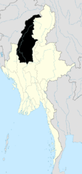
Hkamti District
Hkamti District or Khamti District (sometimes Naga Hills District[1]) is a district in northern Sagaing Division of Burma (Myanmar). Its administrative center is the town of Singkaling Hkamti.
Khamti District ခန္တီးခရိုင် | |
|---|---|
District | |
 Khamti District Location in Burma | |
| Coordinates: 26°00′N 95°41′E | |
| Country | Burma |
| Region | Sagaing Region |
| No. of Townships | 3 |
| Capital | Singkaling Hkamti |
| Time zone | UTC+6.30 (MST) |
The district consists of the two townships:
Prior to 2010,[2] it additionally controlled Lahe, Lay Shi (Lashe), and Nanyun townships, which were transferred under the 2008 Constitution[3] to the Naga Self-Administered Zone. The revised smaller district still has a significant minority Naga population.
Borders
Hkamti District is bordered[4] by:
- India to the west
- Naga Self-Administered Zone to the west and north,
- Myitkyina District and Mohnyin District of Kachin State to the east.
- Katha District to the southeast, and
- Mawlaik District and Tamu District to the south,
Economy
Most people in Hkamti District practice subsistence farming. There is also a jade mine,[5] although most of the jade mining is nearby in Mohnyin District.[6]
Notes
- "Naga Hills District" Geonames
- "တိုင်းခုနစ်တိုင်းကို တိုင်းဒေသကြီးများအဖြစ် လည်းကောင်း၊ ကိုယ်ပိုင်အုပ်ချုပ်ခွင့်ရ တိုင်းနှင့် ကိုယ်ပိုင်အုပ်ချုပ်ခွင့်ရ ဒေသများ ရုံးစိုက်ရာ မြို့များကို လည်းကောင်း ပြည်ထောင်စုနယ်မြေတွင် ခရိုင်နှင့်မြို့နယ်များကို လည်းကောင်း သတ်မှတ်ကြေညာ". Weekly Eleven News (in Burmese). 2010-08-20. Retrieved 2010-08-23.
- ပြည်ထောင်စုသမ္မတမြန်မာနိုင်ငံတော် ဖွဲ့စည်းပုံအခြေခံဥပဒေ (၂၀၀၈ ခုနှစ်) (in Burmese) [0]=1|2008 Constitution PDF Archived 2011-05-01 at the Wayback Machine
- "Myanmar States/Divisions & Townships Overview Map" Archived 2010-12-03 at the Wayback Machine Myanmar Information Management Unit (MIMU)
- "2001 Gem News Archive: Oct. 29, 2001: New Burma Jade Mine" Archived 2009-06-08 at the Wayback Machine Gem News Pala International
- Hughes, Richard W. (2000) "Burmese Jade: The Inscrutable Gem, Part I: Burma's Jade Mines" Pala International
gollark: ...
gollark: ... *how* large?
gollark: It's been done, I think.
gollark: Turbokrist is Java.
gollark: Evil idea: since Krist only lets the first private key work with an address, mine every possible address and slowly begin claiming them on the actual krist server.
External links
This article is issued from Wikipedia. The text is licensed under Creative Commons - Attribution - Sharealike. Additional terms may apply for the media files.
.svg.png)
