Banmauk
Banmauk or Bamauk is a town in the Sagaing Division in Burma. It is connected by road to Pinlebu which links with Phaungbyin and Kawlin.[1] The township is home to the Shan, Kadu and Kanan ethnic minorities, and the region has witnessed fighting between the Communists and the government troops. There is a famous mount called Santlon. Santlon is Shan Language. It means "Great Elephant".[2]
Banmauk | |
|---|---|
Town | |
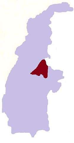
 Banmauk Location in Burma | |
| Coordinates: 24°24′N 95°51′E | |
| Country | |
| Region | |
| District | Katha District |
| Township | Banmauk Township |
| Time zone | UTC+6.30 (MST) |
Notes
- "General Maung Aye on tour of Sagaing Division". The New Light of Myanmar 7 March 2000. Archived from the original on 20 November 2008. Retrieved 20 November 2008.
- "Hmankin Range, native land of Shanne (Tai Leng), Kadu and Kanan nationals". The New Light of Myanmar 12 June 2003. Retrieved 20 November 2008.
gollark: > You'd continually construct the next program to execute (no loop instructions)Well, that's a neat idea.
gollark: This "Whirl" esolang has an interesting iðea.
gollark: No.
gollark: Idea then.
gollark: So HOW DO I BE EOSTIERIC?!?!?!?!?!
External links
- Satellite map of Banmauk Maplandia
Capital: Sagaing | ||
| Hkamti District |
| .svg.png)  |
| Kanbalu District |
| |
| Kale District | ||
| Katha District | ||
| Mawlaik District | ||
| Monywa District | ||
| Sagaing District | ||
| Shwebo District | ||
| Tamu District |
| |
| Yinmabin District |
| |
| Naga Self-Administered Zone |
| |
This article is issued from Wikipedia. The text is licensed under Creative Commons - Attribution - Sharealike. Additional terms may apply for the media files.