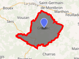
Grassac
Grassac is a commune in the Charente department in southwestern France.
Grassac | |
|---|---|
The D109 road into Grassac | |
 Coat of arms | |
Location of Grassac 
| |
 Grassac  Grassac | |
| Coordinates: 45°35′12″N 0°24′13″E | |
| Country | France |
| Region | Nouvelle-Aquitaine |
| Department | Charente |
| Arrondissement | Angoulême |
| Canton | Val de Tardoire |
| Intercommunality | Seuil Charente-Périgord |
| Government | |
| • Mayor (2008–2014) | Jean-Pierre Claeys |
| Area 1 | 28.23 km2 (10.90 sq mi) |
| Population (2017-01-01)[1] | 323 |
| • Density | 11/km2 (30/sq mi) |
| Time zone | UTC+01:00 (CET) |
| • Summer (DST) | UTC+02:00 (CEST) |
| INSEE/Postal code | 16158 /16380 |
| Elevation | 107–225 m (351–738 ft) (avg. 220 m or 720 ft) |
| 1 French Land Register data, which excludes lakes, ponds, glaciers > 1 km2 (0.386 sq mi or 247 acres) and river estuaries. | |
Population
| Year | Pop. | ±% |
|---|---|---|
| 1793 | 684 | — |
| 1800 | 696 | +1.8% |
| 1806 | 706 | +1.4% |
| 1821 | 700 | −0.8% |
| 1831 | 786 | +12.3% |
| 1841 | 710 | −9.7% |
| 1846 | 740 | +4.2% |
| 1851 | 789 | +6.6% |
| 1856 | 749 | −5.1% |
| 1861 | 690 | −7.9% |
| 1866 | 688 | −0.3% |
| 1872 | 627 | −8.9% |
| 1876 | 620 | −1.1% |
| 1881 | 597 | −3.7% |
| 1886 | 587 | −1.7% |
| 1891 | 544 | −7.3% |
| 1896 | 502 | −7.7% |
| 1901 | 478 | −4.8% |
| 1906 | 464 | −2.9% |
| 1911 | 483 | +4.1% |
| 1921 | 432 | −10.6% |
| 1926 | 444 | +2.8% |
| 1931 | 407 | −8.3% |
| 1936 | 415 | +2.0% |
| 1946 | 372 | −10.4% |
| 1954 | 305 | −18.0% |
| 1962 | 274 | −10.2% |
| 1968 | 280 | +2.2% |
| 1975 | 268 | −4.3% |
| 1982 | 263 | −1.9% |
| 1990 | 285 | +8.4% |
| 1999 | 274 | −3.9% |
| 2008 | 285 | +4.0% |
gollark: I vaguely remember playing on a GregTech pack ages ago. I think I got to something like the low-voltage tier before accidentally exploding my base due to a voltage mismatch of some sort and quitting.
gollark: And it's time-consuming.
gollark: Even with AE2 it's still annoying because you run out of patterns constantly.
gollark: OpenComputers does the same thing. For a CPU you need a control unit and ALU and stuff, which need microchips, which need transistors, which need paper for some reason.
gollark: Often the components then have weird components you need to craft, and while the actual material cost isn't high you spend ages fiddling with machines and crafting tables.
See also
References
- "Populations légales 2017". INSEE. Retrieved 6 January 2020.
| Wikimedia Commons has media related to Grassac. |
This article is issued from Wikipedia. The text is licensed under Creative Commons - Attribution - Sharealike. Additional terms may apply for the media files.