Arrondissement of Angoulême
The arrondissement of Angoulême is an arrondissement of France in the Charente department in the Nouvelle-Aquitaine region. It has 115 communes.[1] Its population is 181,456 (2016), and its area is 1,867.6 km2 (721.1 sq mi).[2]
Angoulême | |
|---|---|
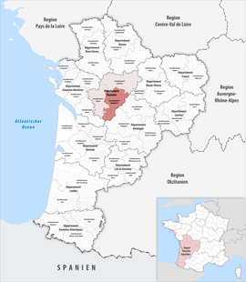 Location within the region Nouvelle-Aquitaine | |
| Country | France |
| Region | Nouvelle-Aquitaine |
| Department | Charente |
| No. of communes | 115 |
| Prefecture | Angoulême |
| Area | |
| • Total | 1,867.6 km2 (721.1 sq mi) |
| Population (2016) | |
| • Total | 181,456 |
| • Density | 97/km2 (250/sq mi) |
| INSEE code | 161 |
Composition
The communes of the arrondissement of Angoulême, and their INSEE codes, are:[1]
- Agris (16003)
- Angoulême (16015)
- Asnières-sur-Nouère (16019)
- Aubeterre-sur-Dronne (16020)
- Balzac (16026)
- Bardenac (16029)
- Bazac (16034)
- Bellon (16037)
- Bessac (16041)
- Blanzaguet-Saint-Cybard (16047)
- Boisné-la-Tude (16082)
- Bonnes (16049)
- Bors-de-Montmoreau (16052)
- Bouëx (16055)
- Brie (16061)
- Brie-sous-Chalais (16063)
- Bunzac (16067)
- Chadurie (16072)
- Chalais (16073)
- Champniers (16078)
- Charras (16084)
- Châtignac (16091)
- Chazelles (16093)
- Claix (16101)
- Combiers (16103)
- Coulgens (16107)
- Courgeac (16111)
- Courlac (16112)
- La Couronne (16113)
- Curac (16117)
- Deviat (16118)
- Dignac (16119)
- Dirac (16120)
- Écuras (16124)
- Édon (16125)
- Les Essards (16130)
- Eymouthiers (16135)
- Feuillade (16137)
- Fléac (16138)
- Fouquebrune (16143)
- Garat (16146)
- Gardes-le-Pontaroux (16147)
- Gond-Pontouvre (16154)
- Grassac (16158)
- Gurat (16162)
- L'Isle-d'Espagnac (16166)
- Jauldes (16168)
- Juignac (16170)
- Laprade (16180)
- Linars (16187)
- Magnac-Lavalette-Villars (16198)
- Magnac-sur-Touvre (16199)
- Mainzac (16203)
- Marillac-le-Franc (16209)
- Marsac (16210)
- Marthon (16211)
- Médillac (16215)
- Montboyer (16222)
- Montbron (16223)
- Montignac-le-Coq (16227)
- Montmoreau (16230)
- Mornac (16232)
- Moulins-sur-Tardoire (16406)
- Mouthiers-sur-Boëme (16236)
- Nabinaud (16240)
- Nersac (16244)
- Nonac (16246)
- Orgedeuil (16250)
- Orival (16252)
- Palluaud (16254)
- Pillac (16260)
- Plassac-Rouffiac (16263)
- Poullignac (16267)
- Pranzac (16269)
- Puymoyen (16271)
- Rioux-Martin (16279)
- Rivières (16280)
- La Rochefoucauld-en-Angoumois (16281)
- La Rochette (16282)
- Ronsenac (16283)
- Rouffiac (16284)
- Rougnac (16285)
- Roullet-Saint-Estèphe (16287)
- Rouzède (16290)
- Ruelle-sur-Touvre (16291)
- Saint-Adjutory (16293)
- Saint-Avit (16302)
- Saint-Germain-de-Montbron (16323)
- Saint-Laurent-des-Combes (16331)
- Saint-Martial (16334)
- Saint-Michel (16341)
- Saint-Quentin-de-Chalais (16346)
- Saint-Romain (16347)
- Saint-Saturnin (16348)
- Saint-Séverin (16350)
- Saint-Sornin (16353)
- Saint-Yrieix-sur-Charente (16358)
- Salles-Lavalette (16362)
- Sers (16368)
- Sireuil (16370)
- Souffrignac (16372)
- Soyaux (16374)
- Taponnat-Fleurignac (16379)
- Torsac (16382)
- Touvre (16385)
- Trois-Palis (16388)
- Vaux-Lavalette (16394)
- Villebois-Lavalette (16408)
- Vindelle (16415)
- Vœuil-et-Giget (16418)
- Voulgézac (16420)
- Vouthon (16421)
- Vouzan (16422)
- Yviers (16424)
- Yvrac-et-Malleyrand (16425)
History
The arrondissement of Angoulême was created in 1800.[3] On 1 January 2008 the four cantons of Aigre, Mansle, Ruffec and Villefagnan that previously belonged to the arrondissement of Angoulême were added to the arrondissement of Confolens, and the canton of Rouillac to the arrondissement of Cognac.[3][4] At the January 2017 reorganisation of the arrondissements of Charente, it lost 14 communes to the arrondissement of Cognac and 15 communes to the arrondissement of Confolens, and it gained two communes from the arrondissement of Cognac.[5]
As a result of the reorganisation of the cantons of France which came into effect in 2015, the borders of the cantons are no longer related to the borders of the arrondissements. The cantons of the arrondissement of Angoulême were, as of January 2015:[6]
- Angoulême-Est
- Angoulême-Nord
- Angoulême-Ouest
- Aubeterre-sur-Dronne
- Blanzac-Porcheresse
- Chalais
- La Couronne
- Gond-Pontouvre
- Hiersac
- Montbron
- Montmoreau-Saint-Cybard
- La Rochefoucauld
- Ruelle-sur-Touvre
- Saint-Amant-de-Boixe
- Soyaux
- Villebois-Lavalette
References
- "Arrondissement d'Angoulême (161)". INSEE. Retrieved 2019-09-27.
- "Comparateur de territoire, géographie au 01/01/2019". INSEE. Retrieved 2019-09-27.
- Historique de la Charente
- "Modification des limites d'arrondissement". Archived from the original on 2007-12-25. Retrieved 2019-10-08.
- "Arrêté préfectoral, 30 December 2016" (PDF). pp. 98–108. Retrieved 2019-10-08.
- "Populations légales 2012" (PDF). INSEE. December 2014. Retrieved 2019-10-08.
| Authority control |
|
|---|