Grade I listed buildings in South Oxfordshire
There are over 9,000 Grade I listed buildings in England. This page is a list of these buildings in the district of South Oxfordshire in Oxfordshire.
List of buildings
| Name | Location | Type | Completed [note 1] | Date designated | Grid ref.[note 2] Geo-coordinates |
Entry number [note 3] | Image |
|---|---|---|---|---|---|---|---|
| Beckley Park | Beckley | House | c.1540 | 18 July 1963 | SP5772211975 51°48′12″N 1°09′51″W |
1180781 | |
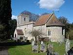
| Church of the Assumption of the Blessed Virgin Mary | Beckley | Church | 14th century | 18 July 1963 | SP5622711262 51°47′50″N 1°11′10″W |
1047650 | 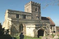 Church of the Assumption of the Blessed Virgin Mary |
| Church of St Bartholomew | Brightwell Baldwin | Church | 13th century | 18 July 1963 | SU6532095002 51°39′00″N 1°03′26″W |
1059763 | 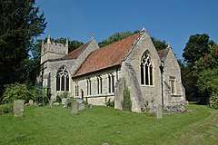 Church of St Bartholomew |
| Small's House | Mackney, Brightwell-cum-Sotwell | House | c.1580 | 9 April 1952 | SU5790989973 51°36′20″N 1°09′55″W |
1368884 | 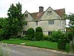 Small's House |
| Church of St Mary | Chalgrove | Church | Early 13th century | 18 July 1963 | SU6371696549 51°39′51″N 1°04′49″W |
1284879 | 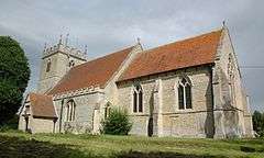 Church of St Mary |
| The Manor | Chalgrove | Hall House | Early 15th century | 18 July 1963 | SU6306197027 51°40′07″N 1°05′22″W |
1368856 |  |
| Church of St Peter and St Paul | Checkendon | Church | 12th century | 9 February 1959 | SU6632283040 51°32′33″N 1°02′42″W |
1180822 | |
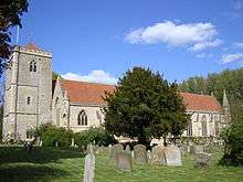
| Church of St Andrew | Chinnor | Church | Early 13th century | 18 July 1963 | SP7567900889 51°42′06″N 0°54′23″W |
1368881 | 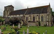 Church of St Andrew |
| Church of St Mary | Cholsey | Church | 11th century | 14 June 1963 | SU5837487007 51°34′44″N 1°09′32″W |
1059283 | 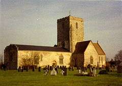 Church of St Mary |
| Church of St Mary Magdalene | Crowmarsh Gifford | Church | 12th century | 9 February 1959 | SU6146689314 51°35′58″N 1°06′50″W |
1059582 | 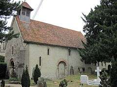 Church of St Mary Magdalene |
| Church of All Saints | Cuddesdon | Church | Mid–late 12th century | 18 July 1963 | SP6007803045 51°43′23″N 1°07′54″W |
1047709 |  Church of All Saints |
| Abbey Church of St Peter and St Paul | Dorchester on Thames | Abbey | 1140–1536 | 18 July 1963 | SU5792794196 51°38′37″N 1°09′51″W |
1193595 | |
| Churchyard cross approximately 6 metres south of Dorchester Abbey | Dorchester on Thames | Cross | 14th/15th century | 18 July 1963 | SU5789094188 51°38′37″N 1°09′53″W |
1047865 |  Churchyard cross approximately 6 metres south of Dorchester Abbey |
| Church of St Andrew | East Hagbourne | Church | 12th century | 14 June 1963 | SU5254988196 51°35′25″N 1°14′34″W |
1047927 | 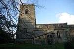 Church of St Andrew |
| Church of St Mary | Ewelme | Church | c.1432 | 18 July 1963 | SU6466091405 51°37′04″N 1°04′03″W |
1059360 | 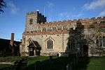 Church of St Mary |
| Ewelme Church of England Primary School | Ewelme | School | c.1450 | 18 July 1963 | SU6459891360 51°37′03″N 1°04′06″W |
1369062 | 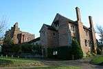 Ewelme Church of England Primary School |
| Gods Place, and lobby to Church of St Mary | Ewelme | Almshouse | c.1437 | 18 July 1963 | SU6463691394 51°37′04″N 1°04′04″W |
1369023 | 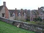 Gods Place, and lobby to Church of St Mary |
| School House and archway | Ewelme | School house | Mid-15th century | 18 July 1963 | SU6460491379 51°37′03″N 1°04′06″W |
1059349 | School House and archway |
| Church of St Thomas of Canterbury | Goring on Thames | Church | 12th century | 9 February 1959 | SU5976480711 51°31′20″N 1°08′24″W |
1194201 | 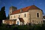 Church of St Thomas of Canterbury |
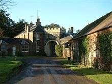
| Alnutts Hospital and attached forecourt walls and gate | Goring Heath | Almshouses | c. 1724 | 24 October 1951 | SU6569779447 51°30′37″N 1°03′17″W |
1194275 | 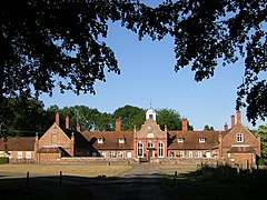 Alnutts Hospital and attached forecourt walls and gate |
| Church of St Peter | Great Haseley | Church | c. 1200 | 18 July 1963 | SP6443101695 51°42′37″N 1°04′08″W |
1047529 | 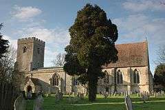 Church of St Peter |
| Tithe barn at Church Farm and attached wall at the stables | Great Haseley | Tithe barn | c. 1400 | 18 July 1963 | SP6444501765 51°42′39″N 1°04′07″W |
1047532 | |
| Church of St Mary | Great Milton | Church | 11th century | 18 July 1963 | SP6279902422 51°43′01″N 1°05′33″W |
1369258 | 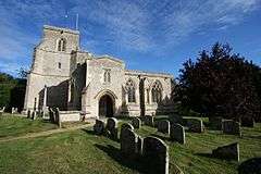 Church of St Mary |
| Chantry House | Henley-on-Thames | Chantry college | c. 1400 | 25 January 1951 | SU7629382693 51°32′17″N 0°54′05″W |
1047033 | 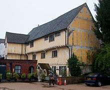 Chantry House |
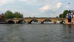
| Henley Bridge | Henley-on-Thames | Bridge | 1786 | 25 January 1951 | SU7634282644 51°32′15″N 0°54′02″W |
1369131 | |
| Church of St Bartholomew | Holton | Church | Late 12th century | 18 July 1963 | SP6051806391 51°45′11″N 1°07′29″W |
1047596 | 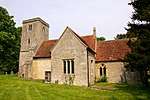 Church of St Bartholomew |
| Church Farm, barn approximately 30 metres ESE of farmhouse (not included) | Lewknor | House | Mid-/late 14th century | 19 November 1976 | SU7150697658 51°40′23″N 0°58′02″W |
1368861 | |
| Church of St Margaret | Lewknor | Church | Late 12th century | 18 July 1963 | SU7157297650 51°40′23″N 0°57′59″W |
1182190 | 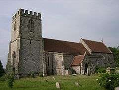 Church of St Margaret |
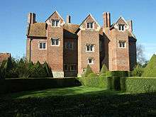
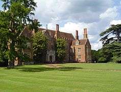
| Haseley Court | Little Haseley | Country house | 14th century | 18 July 1963 | SP6449300596 51°42′01″N 1°04′06″W |
1047539 | 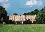 Haseley Court |
| Church of St Mary | Long Wittenham | Church | c. 1120 | 14 June 1963 | SU5484894043 51°38′33″N 1°12′32″W |
1368798 | 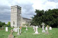 Church of St Mary |
| Church of St Margaret and Bardolf Aisle | Mapledurham | Church | 13th century | 9 February 1959 | SU6700576676 51°29′06″N 1°02′11″W |
1059519 | 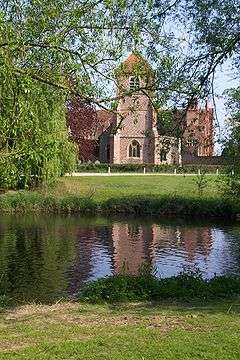 Church of St Margaret and Bardolf Aisle |
| Mapledurham House | Mapledurham | Country house | c. 1585 | 24 October 1951 | SU6706776655 51°29′06″N 1°02′08″W |
1368944 | |
| Church of St Giles | Newington | Church | 12th century | 18 July 1963 | SU6087896527 51°39′51″N 1°07′16″W |
1193229 | 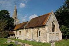 Church of St Giles |
| Church of All Saints | North Moreton | Church | Early 13th century | 14 June 1963 | SU5620689569 51°36′08″N 1°11′24″W |
1181258 | 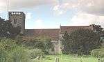 Church of All Saints |
| Church of St Mary | North Stoke | Church | 13th century | 9 February 1959 | SU6089786210 51°34′17″N 1°07′22″W |
1059577 | 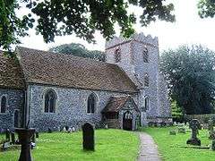 Church of St Mary |
| Carfax Conduit | Nuneham Courtenay | Conduit | 1617 | 18 July 1963 | SU5372797671 51°40′31″N 1°13′28″W |
1193569 | |
| Rycote Chapel | Rycote | Church | 1449 | 18 July 1963 | SP6669904651 51°44′12″N 1°02′08″W |
1047514 | 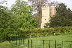 Rycote Chapel |
| Greys Court | Rotherfield Greys | House | 14th century | 24 October 1951 | SU7248283417 51°32′42″N 0°57′22″W |
1181202 | |
| Greys Court, Dower House | Rotherfield Greys | Dower house | 16th century | 24 October 1951 | SU7254483383 51°32′41″N 0°57′19″W |
1047391 | 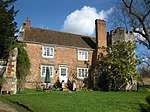 Greys Court, Dower House |
| Greys Court, Great Tower, attached ruined tower and walls approximately 60 metres east | Rotherfield Greys | Fortified house | 14th century | 24 October 1951 | SU7254183441 51°32′43″N 0°57′19″W |
1181246 | 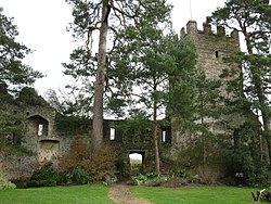 Greys Court, Great Tower, attached ruined tower and walls approximately 60 metres east |
| Greys Court, the Keep | Rotherfield Greys | Keep | 14th century | 24 October 1951 | SU7244983374 51°32′41″N 0°57′24″W |
1369333 | 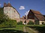 Greys Court, the Keep |
| Greys Court, Well House | Rotherfield Greys | Timber-framed house | 16th century | 24 October 1951 | SU7246783373 51°32′41″N 0°57′23″W |
1369334 | Greys Court, Well House |
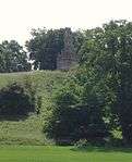
| Shirburn Castle | Shirburn | Castle | 1377 | 18 July 1963 | SU6966095976 51°39′30″N 0°59′40″W |
1368852 | |
| Shotover Park | Shotover | Country house | c.1715–20 | 18 July 1963 | SP5841506714 51°45′22″N 1°09′18″W |
1284986 | |
| Church of St John the Baptist | Stanton St. John | Church | c. 1200 | 18 July 1963 | SP5775009372 51°46′48″N 1°09′51″W |
1182305 | 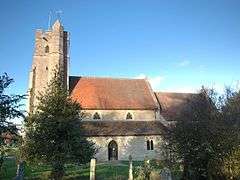 Church of St John the Baptist |
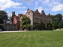
| Stonor House and attached walls and buildings | Stonor | Country house | 13th century | 24 October 1951 | SU7425289228 51°35′49″N 0°55′46″W |
1059444 | 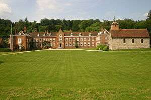 Stonor House and attached walls and buildings |
| Chapel approximately 10 metres south of the Prebendal | Thame | Chapel | c. 1250 | 24 April 1951 | SP7021906359 51°45′06″N 0°59′03″W |
1180882 |  Chapel approximately 10 metres south of the Prebendal |
| Church of St Mary | Thame | Church | Early 13th century | 24 April 1951 | SP7038506318 51°45′04″N 0°58′54″W |
1194053 | 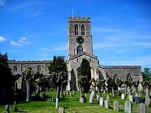 Church of St Mary |
| Thame Park House | Thame | Country house | 14th century | 24 April 1951 | SP7167203727 51°43′40″N 0°57′49″W |
1368734 | 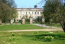 Thame Park House |
| Fragment of castle wall at Wallingford Castle | Wallingford | Bailey | 13th century | 9 December 1949 | SU6096589780 51°36′13″N 1°07′16″W |
1181852 | |
| Remains of Queen's Tower, Wallingford Castle | Wallingford | Castle | 13th century | 9 December 1949 | SU6103489717 51°36′11″N 1°07′12″W |
1059619 | 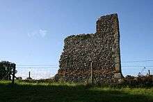 Remains of Queen's Tower, Wallingford Castle |
| Remains of St Nicholas's College | Wallingford | Motte and bailey | 13th century | 9 December 1949 | SU6090489595 51°36′07″N 1°07′19″W |
1181912 | 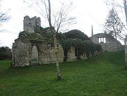 Remains of St Nicholas's College |
| Town Hall | Wallingford | Guildhall | c. 1670 | 9 December 1949 | SU6071689359 51°35′59″N 1°07′29″W |
1368477 |  Town Hall |
| Church of St Mary | Waterperry | Church | Saxon | 18 July 1963 | SP6295606322 51°45′07″N 1°05′22″W |
1047587 | 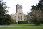 Church of St Mary |
| Church of St Mary, churchyard cross approximately 10 metres to south | Waterperry | Cross | Medieval | 5 June 1985 | SP6295706309 51°45′07″N 1°05′22″W |
1047588 | 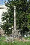 Church of St Mary, churchyard cross approximately 10 metres to south |
| Church of St Andrew | Wheatfield | Church | 14th century | 18 July 1963 | SU6886799274 51°41′17″N 1°00′19″W |
1059672 | 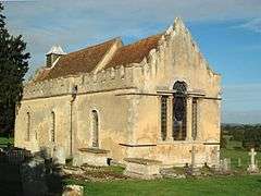 Church of St Andrew |
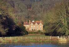
| Hardwick House | Whitchurch-on-Thames | Country house | Early 16th century | 24 October 1951 | SU6593377732 51°29′41″N 1°03′06″W |
1180567 | |
| Hardwick House: Dower House approximately 5 metres west | Whitchurch-on-Thames | House | Late 17th century | 16 August 1985 | SU6592477748 51°29′41″N 1°03′06″W |
1059525 | 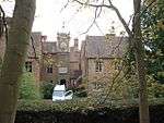 Hardwick House: Dower House approximately 5 metres west |
| Church of the Holy Rood | Woodeaton | Church | 13th century | 18 July 1963 | SP5348911898 51°48′11″N 1°13′32″W |
1047562 | 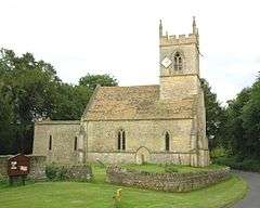 Church of the Holy Rood |
| Woodeaton Cross | Woodeaton | Village cross | Medieval | 18 July 1963 | SP5349811960 51°48′13″N 1°13′32″W |
1047563 | 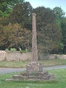 Woodeaton Cross |
| The Old Brewhouse with entrance screen, Woodperry House | Woodperry, Stanton St. John | Country house | 1728–31 | 18 July 1963 | SP5751010430 51°47′22″N 1°10′03″W |
1047582 | |
.jpg)
gollark: Memetics.
gollark: You're not very good at this.
gollark: You did.
gollark: You did understand it, you just unconsciously erased your understanding of it.
gollark: Use z3?
See also
Notes
- The date given is the date used by Historic England as significant for the initial building or that of an important part in the structure's description.
- Sometimes known as OSGB36, the grid reference is based on the British national grid reference system used by the Ordnance Survey.
- The "List Entry Number" is a unique number assigned to each listed building and scheduled monument by Historic England.
External links
![]()
This article is issued from Wikipedia. The text is licensed under Creative Commons - Attribution - Sharealike. Additional terms may apply for the media files.