Graben
In geology, a graben (/ˈɡrɑːbən/) is a depressed block of the crust of a planet bordered by parallel faults.


Etymology
Graben is German for ditch or trench. The plural form is either graben[1] or grabens.[2] The German plural is Gräben.
Formation
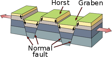
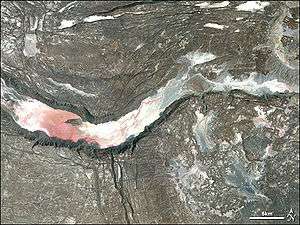
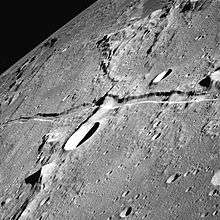
A graben is a valley with a distinct escarpment on each side caused by the displacement of a block of land downward. Graben often occur side-by-side with horsts. Horst and graben structures indicate tensional forces and crustal stretching.
Graben are produced from parallel normal faults, where the displacement of the hanging wall is downward, while that of the footwall is upward. The faults typically dip toward the center of the graben from both sides. Horsts are parallel blocks that remain between graben; the bounding faults of a horst typically dip away from the center line of the horst. Single or multiple graben can produce a rift valley.
Half-graben

In many rifts, the graben are asymmetric, with a major fault along only one of the boundaries, and these are known as half-graben. The polarity (throw direction) of the main bounding faults typically alternates along the length of the rift. The asymmetry of a half-graben strongly affects syntectonic deposition. Comparatively little sediment enters the half-graben across the main bounding fault because of footwall uplift on the drainage systems. The exception is at any major offset in the bounding fault, where a relay ramp may provide an important sediment input point. Most of the sediment will enter the half-graben down the unfaulted hanging wall side (e.g. Lake Baikal).[3]

Examples
Antarctica
Africa
- East African Rift Valley
- Lucapa Graben, Lunda Norte Province, Angola
Asia
- Narmada River Valley, central India
- lower Godavari River Valley, southern India
- Baikal Rift Zone, Siberia, Russia
- Moma Graben, Sakha Republic, Russia
- Büyük Menderes Graben, Turkey
- Unzen Graben, Japan
Europe
- Rhine valley, border area of west Germany and northeast France
- Oslo graben around Oslo, Norway
- Central Lowlands, Scotland
- Worcester Basin, England
- Central Graben, North Sea
- Viking Graben, North Sea
- Vättern, Sweden
North America
Canada
- Ottawa-Bonnechere Graben, Ontario and Quebec, Canada
- Saguenay Graben, Quebec, Canada
Guatemala
- Guatemala City valley, Guatemala
United States
- Basin and Range Province of southwestern North America is an example of multiple horst/graben structures, including Death Valley, with Salt Lake Valley being the easternmost and Owens Valley being the westernmost.
- Lake George Basin, New York, U.S.
- Lake Tahoe Basin, California and Nevada, U.S.
- Republic Graben, Republic, Washington, U.S.
- Rio Grande Rift Valley in Colorado/New Mexico/Texas of the United States
- Rough Creek Graben, Kentucky, U.S.
- Santa Clara Valley, California, U.S.
- Western Snake River Plain, Idaho, U.S.
Multi-national
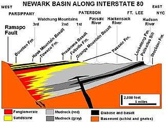
- Eastern North America Rift Basins, Canada and U.S.
- Midcontinent Rift System, Canada and U.S.
- Salton Trough, Mexico and U.S.
Oceania
South America
See also
- European Cenozoic Rift System
- Fossa (geology)
Notes
- Schlumberger Oilfield Glossary
- "horst and graben". Encyclopædia Britannica. Retrieved 2012-11-15.
- Hans Nelson, C.; Karabanov, Evgeny B.; Colman, Steven M.; Escutia, Carlota (1999). "Tectonic and sediment supply control of deep rift lake turbidite systems: Lake Baikal, Russia". Geology. 27 (2): 163–166. doi:10.1130/0091-7613(1999)027<0163:TASSCO>2.3.CO;2.
- Sprigg, R.C. (1961). "The Oil and Gas Prospects of the St. Vincents Gulf Graben". The APPEA Journal. 1 (1): 71–88. doi:10.1071/AJ60011.
References
- McKnight, Tom L; Hess, Darrel (2000). "The Internal Processes: Graben". Physical Geography: A Landscape Appreciation. Upper Saddle River, NJ: Prentice Hall. pp. 417. ISBN 0-13-020263-0.