Geolocation
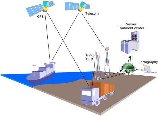
Geolocation is the identification or estimation of the real-world geographic location of an object, such as a radar source, mobile phone, or Internet-connected computer terminal. In its simplest form, geolocation involves the generation of a set of geographic coordinates and is closely related to the use of positioning systems, but its usefulness is enhanced by the use of these coordinates to determine a meaningful location, such as a street address.

The word geolocation also refers to the latitude and longitude coordinates of a particular location. The term and definition have been standardized by real-time locating system standard ISO/IEC 19762-5:2008.
In the field of animal biology and ecology, the word geolocation is also used to refer to the process of inferring the location of a tracked animal based, for instance, on the time history of sunlight brightness[1] or the water temperature and depth[2] measured by an instrument attached to the animal. Such instruments are commonly called archival tags (including microchip implants, Pop-up satellite archival tags, and data storage tags) or dataloggers.[3]
Techniques
For either geolocating or positioning, the locating engine often uses radio frequency (RF) location methods, for example Time Difference Of Arrival (TDOA) for precision. TDOA systems often use mapping displays or other geographic information system. When satellite navigation (such as GPS) signals are unavailable, geolocation applications can use information from cell towers to triangulate the approximate position, a method that is not as accurate as GPS but has greatly improved in recent years.[4] This is in contrast to earlier radiolocation technologies, for example Direction Finding where a line of bearing to a transmitter is achieved as part of the process.
Internet and computer geolocation can be performed by associating a geographic location with the Internet Protocol (IP) address, RFID, hardware embedded article/production number, embedded software number (such as UUID, Exif/IPTC/XMP or modern steganography), invoice, Wi-Fi positioning system, device fingerprint, canvas fingerprinting or device GPS coordinates, or other, perhaps self-disclosed information.[5]
IP address location data can include information such as country, region, city, postal/zip code,[6] latitude, longitude and time zone.[7] Deeper data sets can determine other parameters such as domain name, connection speed, ISP, language, proxies, company name, US DMA/MSA, NAICS codes, and home/business.
At times geolocation can be more deductive, as with crowdsourcing efforts to determine the position of videos of training camps, combats, and beheadings in Syria by comparing features detected in the video with publicly available map databases such as Google Earth, as practiced by sites such as Bellingcat.[8][9]
Standards
Some standards and name servers include: ISO 3166, FIPS, INSEE, Geonames, IATA and ICAO. For geographic locations in the United States, the American National Standards Institute (ANSI) Codes are often used. ANSI INCITS 446-2008 is entitled "Identifying Attributes for Named Physical and Cultural Geographic Features (Except Roads and Highways) of the United States, Its Territories, Outlying Areas, and Freely Associated Areas, and the Waters of the Same to the Limit of the Twelve-Mile Statutory Zone A number of commercial solutions have been proposed:
- WOEID (Where on Earth IDentifier) is a unique 32-bit reference identifier that identifies any feature on Earth.
- NAC Locator provides a universal geocoding address for all locations on the planet.
See also
- planet Earth is a unique ever-changing geoid
- Map–territory relation (in philosophy of geography)
- Geo-blocking
- Geocoding
- Geolocation Database
- Geolocation software
- Geolocation Video
- Geomarketing
- Geotagged photo
- Geotagging
- Geo targeting
- Indoor positioning
- Location-based service
- Mobile phone tracking
- Positioning
- Web analytics
- W3C Geolocation API
References
- Hill, Roger D.; Braun, Melinda J. (2001). "Geolocation by Light Level". Electronic Tagging and Tracking in Marine Fisheries. Reviews: Methods and Technologies in Fish Biology and Fisheries. 1. pp. 315–330. doi:10.1007/978-94-017-1402-0_17. ISBN 978-90-481-5871-3.
- Lam, Chi H.; Nielsen, Anders; Sibert, John R. (2008). "Improving light and temperature based geolocation by unscented Kalman filtering". Fisheries Research. 91: 15–25. doi:10.1016/j.fishres.2007.11.002.
- Galuardi, Benjamin; Lam, Chi Hin (Tim) (2014). "Telemetry Analysis of Highly Migratory Species". Stock Identification Methods. pp. 447–476. doi:10.1016/B978-0-12-397003-9.00019-9. ISBN 9780123970039.
- Ionescu, Daniel (2010-03-29). "Geolocation 101: How It Works, the Apps, and Your Privacy". PCWorld. Archived from the original on June 15, 2013. Retrieved March 29, 2010.
- Holdener, Anthony T. (2011). HTML5 Geolocation. O'Reilly Media. p. 11. ISBN 9781449304720.
- "Digital Element Finding Demand for Granular IP Targeting". 2009-08-20. Archived from the original on 2011-12-17. Retrieved 2011-12-11.
- IPInfoDB (2009-07-10). "IP Geolocation database". IPInfoDB. Archived from the original on 2009-06-11. Retrieved 2009-07-18.
- David Leveille (2014-08-29). "This hobbyist-turned-journalist is a one-man digital detective agency". PRI. Archived from the original on 2014-09-24. Retrieved 2014-09-20.
- "Crowd-Funded Journalists Geo-Locate ISIS Training Camp Using the Militants' Own Photos". PetaPixel. 2014-08-25. Archived from the original on 2014-09-24. Retrieved 2014-09-20.
External links
