Fornos de Algodres
Fornos de Algodres (Portuguese pronunciation: [ˈfɔɾnuʒ ðɨ ɐlˈɣoðɾɨʃ] (![]()
Fornos de Algodres | |
|---|---|
 Flag  Coat of arms | |
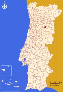 | |
| Coordinates: 40°37′N 7°32′W | |
| Country | |
| Region | Centro |
| Intermunic. comm. | Beiras e Serra da Estrela |
| District | Guarda |
| Parishes | 12 |
| Government | |
| • President | Manuel Fonseca (PS) |
| Area | |
| • Total | 131.45 km2 (50.75 sq mi) |
| Population (2011) | |
| • Total | 4,989 |
| • Density | 38/km2 (98/sq mi) |
| Time zone | UTC±00:00 (WET) |
| • Summer (DST) | UTC+01:00 (WEST) |
| Local holiday | Saint Michael September 29 |
| Website | http://www.cm-fornosdealgodres.pt |
The seat of the municipality, Fornos de Algodres, is a historic town and boasts panoramic views of the upper Mondego river Valley and a nineteenth-century market with nearby winding cobbled streets as well as the Serra da Estrela, the highest mountain range in mainland Portugal. Cities nearby: Mangualde, Gouveia, Seia, Guarda, Viseu, Trancoso, Pinhel.
Gastronomy: Queijo da Serra (hard cheese); requeijões (soft cheese). Train station: Fornos de Algodres Linha da Beira Alta.
Parishes
Administratively, the municipality is divided into 12 civil parishes (freguesias):[3]
- Algodres
- Casal Vasco
- Cortiçô e Vila Chã
- Figueiró da Granja
- Fornos de Algodres (Town/Vila)
- Infias
- Juncais, Vila Ruiva e Vila Soeiro do Chão
- Maceira
- Matança
- Muxagata
- Queiriz
- Sobral Pichorro e Fuinhas
References
- Instituto Nacional de Estatística
- "Áreas das freguesias, concelhos, distritos e país". Archived from the original on 2018-11-05. Retrieved 2018-11-05.
- Diário da República. "Law nr. 11-A/2013, page 552 51" (pdf) (in Portuguese). Retrieved 23 July 2014.
External links
| Authority control |
|
|---|