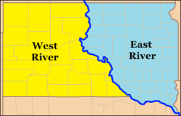
East River (South Dakota)
The East River portion of South Dakota refers to the section of the state lying east of the Missouri River. Geographical distinctions between the eastern and western sections of the state were reinforced by differing patterns of European-American settlement and Native American resettlement during the 19th and 20th centuries.

The eastern half of South Dakota was heavily glaciated and is largely covered by glacial till and loamy soil, which has lent itself to agricultural uses. The Missouri River roughly follows the 100th meridian in the state, and areas to the west of the meridian receive less rainfall. The East River region was generally capable of supporting homesteaders on the standard 160-acre plots of the era during the wetter-than average years between 1879 and 1885; prolonged droughts between 1886 and 1897, however, severely affected the region's farmers.[1]
During the second half of the 19th century, about 350,000 immigrants from western and northern Europe settled to the east of the Missouri. The later European immigrants, however, predominantly from southern and eastern Europe, settled in the West River region after 1889, when the federal government made some 9 million acres of former Lakota land available for purchase after breaking up the Great Sioux Reservation, established under the Fort Laramie Treaty of 1868. It reassigned Native Americans to five smaller reservations in West River, and two in East River.
About 70% of South Dakota's population in the 1990s was located in the East River region, which includes major businesses, industries and state government. This area includes the state's largest city, Sioux Falls, and Pierre, the state capital, located on the east bank of the Missouri River.[2]
Since the 1960s and the rise of Indian activism, numerous Native Americans have returned to the reservations in the state. In addition, they have a young population with a relatively high birth rate. Native Americans make up the fastest-growing segment of the population in the state as a whole.[3] In the 1990s, Bennett County in West River developed a majority-Native American population.[4] From 2000 to 2010, the total Native American population in the state grew by 15 percent.[5]
Footnotes
- Herbert S. Schell (October 1931). "Drought and Agriculture in Eastern South Dakota During the Eighteen Nineties". Agricultural History. Agricultural History Society, cited through JSTOR. 5: 162–180. JSTOR 3739326.
- "A South Dakota Statistical Collection" (PDF). South Dakota Legislature. Archived from the original (PDF) on 2009-03-11. Retrieved 2009-07-29.
- Herbert T. Hoover, "South Dakota: Modern Indian Tribes", The American Midwest: An Interpretive Encyclopedia], edited by Andrew R. L. Cayton, Richard Sisson, Chris Zacher, Indiana University Press, 2006, p. 50
- Sterling Fluharty. "Review of Wagoner, Paula L., "They Treated Us Just Like Indians": The Worlds of Bennett County, South Dakota ", H-AmIndian, H-Net Reviews, March 2004, accessed 8 June 2011
- Mary Garrigan, "State's Native American population grows 15 percent", Rapid City Journal, 17 February 2011; accessed 16 August 2016
References
- The American Midwest: An Interpretive Encyclopedia. Richard Sisson, Christian K. Zacher, Andrew Robert Lee Cayton. Indiana University Press, 2006. ISBN 978-0-253-34886-9.
