Eagle's Nest, Hong Kong
Eagle's Nest (Chinese: 鷹巢山), also known indigenously as Tsim Shan (尖山), is a hill north of Cheung Sha Wan of Hong Kong. The hill peaks at 305 metres and is within Sha Tin District with border to Sham Shui Po District at her south. The hill is located northeast of Piper's Hill and northwest of Crow's Nest. Eagle's Natural Trail goes around her peak while the Stage 5 of MacLehose Trail runs on her north.[1][2]
| Eagle's Nest, Hong Kong | |
|---|---|
| 尖山 | |
 Eagle's Nest, Hong Kong Location of Eagle's Nest in Hong Kong | |
| Highest point | |
| Elevation | 305 m (1,001 ft) |
| Coordinates | 22°20′47.29″N 114°9′37.43″E |
| Geography | |
| Location | |
Transport
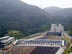
Eagles Nest Tunnel Shatin Entrance
The hill is the site of Eagle's Nest Tunnel, a major infrastructure project in the area.
gollark: Water tastes too bland and I don't really make recipes.
gollark: Well, I drink milk lots in *glasses*.
gollark: ↓ LyricLy, being wrong.
gollark: I don't believe LyricTech™ has access to the future information needed for that.
gollark: Our GTech™ thing meters™ trivially refute your bad™ proposition.
References
- Tang, Timothy. "Traffic Statistics - Eagle's Nest Tunnel and Sha Tin Heights Tunnel". Hong Kong Transport Department. Retrieved 9 January 2019.
- "Sha Tin Pass Road to Kowloon Reservoir | Hong Kong Tourism Board". www.discoverhongkong.com. Retrieved 2020-04-05.
See also
| 900 meters or more | |
|---|---|
| 800 to 899 meters | |
| 700 to 799 meters | |
| 600 to 699 meters |
|
| 500 to 599 meters |
|
| 400 to 499 meters (excerpt) |
|
| 300 to 399 meters (excerpt) |
|
| 200 to 299 meters (excerpt) |
|
| 100 to 199 meters (excerpt) |
|
| 99 meters or less (excerpt) |
|
| Collectively |
|
This article is issued from Wikipedia. The text is licensed under Creative Commons - Attribution - Sharealike. Additional terms may apply for the media files.