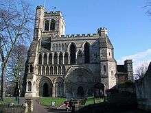
Dunstable
Dunstable (/ˈdʌnstəbəl/ DUN-stə-bəl) is a market town and civil parish in Bedfordshire, East of England. It lies on the eastward tail spurs of the Chiltern Hills, 30 miles (50 kilometres) north of London. These geographical features form several steep chalk escarpments most noticeable when approaching Dunstable from the north. Dunstable is the largest settlement in Central Bedfordshire and third largest in Bedfordshire behind Luton and Bedford. Along with Houghton Regis and the much larger town of Luton it forms the westernmost part of the Luton/Dunstable Urban Area.
| Dunstable | |
|---|---|
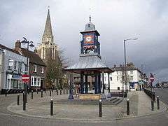 Clock Tower and Market Cross | |
 Dunstable Location within Bedfordshire | |
| Population | 35,000 [1] 36,253 (2011 Census)[2] |
| OS grid reference | TL0121 |
| Unitary authority | |
| Ceremonial county | |
| Region | |
| Country | England |
| Sovereign state | United Kingdom |
| Post town | DUNSTABLE |
| Postcode district | LU5, LU6 |
| Dialling code | 01582 |
| Police | Bedfordshire |
| Fire | Bedfordshire and Luton |
| Ambulance | East of England |
| UK Parliament | |
Etymology
In Roman times its name was Durocobrivis.
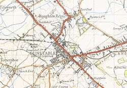
There was a general assumption that the nominative form of the name had been Durocobrivae, so that is what appears on the map of 1944 illustrated below. But current thinking is that the form Durocobrivis, which occurs in the Antonine Itinerary, is a fossilised locative that was used all the time[3] and Ordnance Survey now uses this form.
There are several theories concerning its modern name:
- Legend tells that the lawlessness of the time was personified in a thief called Dun. Wishing to capture Dun, the King stapled his ring to a post daring the robber to steal it. It was, and was subsequently traced to the house of the widow Dun. Her son, the robber, was taken and hanged to the final satisfaction that the new community bore his name.[4]
- It comes from the Anglo-Saxon for "the boundary post of Duna".[4][5]
- Derived from Dunum, or Dun, a hill, and Staple, a marketplace.[6][7]
History
Ancient history
Relics of Palæolithic humans, including such relics as flint implements and the bones of contemporary wild animals, suggest settlement is prehistoric. At Maidenbower in the parish of Houghton Regis to the north, there is an Iron Age hill fort, which is clearly marked on the Ordnance survey maps. Maidenbower has some of the ramparts showing through the edge of an old chalk quarry at Sewell where there are Bronze Age remains of an older fort. There are a lot of prehistoric sites in this area and details can be found with the Manshead Archaeological Society who are based in Winfield Street, Dunstable. Dunstable is on the route of the Icknield Way, which is claimed to be 'the oldest road in Britain'.
Roman settlement
There was already some form of settlement by the AD 40s and 50s, when the Romans arrived and paved the road now known as Watling Street and its crossroad, the Icknield Way.[8][9] Traces of Neolithic activity are not in doubt but much of their mystery may be lost under the surrounding Chiltern Hills.
The Romans built a posting station and probably named the settlement Durocobrivae, but over time this may have shifted to Durocobrivis. The area was occupied by Saxons around AD 571.
Medieval times
Dunstable's modern structure dates back to Anglo-Saxon times, as do many of the nearby towns/villages. The etymology of Dunstable, akin to Luton, Houghton Regis, Totternhoe, Kensworth, Caddington, Toddington, Leighton Buzzard, etc. is Anglo-Saxon in origin, and believed to mean "Dun's market", "Downs' market" (,i.e. market near the downs or hills), or "Dun's post/pole". There is no firm date as to the founding of Dunstable. However, it's possible that once the early Anglo-Saxon settled in the area, and had subdued local Romano-Britons, Dunstable along with its adjacent communities was founded between the 6th-8th centuries. During the Heptarchy period, what was to become Bedfordshire was part of the Kingdom of Mercia. This area of southern Bedfordshire was near the Danelaw boundary (the river Lea running through Luton), though within the territory ruled by King Alfred the Great in his treaty with the Norse Lord Guthrum.
There were raids by Norsemen, who had settled in Bedford and further north in Northampton and up to the Leicester/Rutland regions, for cattle, crops, slaves, and other items, which were often repelled by local Anglo-Saxon forces. One such raid occurred in 912, where Norse jarls from the East Midlands arranged raids of what is now southern Bedfordshire, including the Luton and Dunstable areas. However, Norse activity in the area was subdued after the Anglo-Saxon victory at the Battle of Tempsford, believed to have been fought further north in the county. Bedfordshire and by extension the Dunstable area was affected by later Norse raids, under Kings Sweyn Forkbeard and Cnut of Denmark, in response to the St. Bride's Massacre executed by King Athelred the Unready of England. From 1002, (the date of the Massacre) to 1016 (the ascension of Cnut as King of England), the Anglo-Saxon Chronicle states that Bedfordshire was heavily affected by Norse harrying.
At the time of the Norman Conquest, this area of the county is known to have been uncultivated tract covered by woodlands. In 1109, Henry I started a period of activity by responding to this danger to travellers. He instructed areas to be cleared and encouraged settlers with offers of royal favour.[10] In 1123, a royal residence was built at what is now called the Royal Palace Lodge Hotel on Church Street. The king used the residence as a base to hunt on nearby lands.
The Dunstable Priory was founded in 1131 by the King and was later used for the divorce between Henry VIII and Catherine of Aragon, which led to the establishment of the Church of England in opposition to the Roman Catholic Church. The same year the town granted a town charter to the power of the priors.
In 1290, Dunstable was one of twelve sites to erect an Eleanor cross recognising Eleanor of Castile, wife of Edward I, whose coffin was laid close to the crossroads for the local people to mourn the dead Queen. The coffin was then guarded inside the priory by the canons overnight before continuing on to St. Albans.[11] The original wooden cross has long since perished but a modern memorial remains.
During the Invasion of England of 1326, Queen Isabella of France and her army, having landed in Suffolk, captured Dunstable on 7 October without a fight.[12]
17th century
Bedfordshire was one of the counties that largely supported the Roundheads during the English Civil War. Nearby St Albans in Hertfordshire was the headquarters of the Roundheads, and troops were occasionally stationed at Dunstable. The town was plundered by King Charles I's soldiers when passing through in June 1644, and Essex's men destroyed the Eleanor cross.[8]
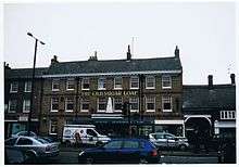
The town's prosperity, and the large number of inns or public houses in the town, is partly because it is only one or two days' ride by horse from London (32 miles (51 km)), and therefore a place to rest overnight. There are two pubs which still have coaching gates to the side: the Sugar Loaf in High Street North, and the Saracen's Head in High Street South. The Saracen's Head is a name often given to pubs frequented by knights of the crusades. It is positioned considerably lower than the road to its front, witness to the fact that the road has been resurfaced a number of times during the lifetime of the pub.
19th century
Dunstable's first railway opened in 1848. It was a branch joining the West Coast Main Line at Leighton Buzzard. A second line linking Dunstable with Hatfield via Luton opened in 1858. Passenger services to Dunstable were withdrawn in 1965, but the line between Dunstable and Luton remained open for freight traffic for many years.
Dunstable was a significant market town, but its importance diminished as the neighbouring town of Luton grew.
20th century
The 19th century saw the straw hat making industry come to Luton and a subsequent decline in Dunstable, to be replaced in the early 20th century by the printing and motor vehicle industries, with companies such as Waterlow's and Vauxhall Motors respectively. The new Bedford Dunstable plant came into production in 1942 to support the British Army in the Second World War. It continued commercial truck and bus until 1992. The closure of the main factories and the decline of manufacturing in the area has led to this distinctiveness being lost.
Shops were concentrated along High Street North/South (Watling Street) and in 1966 the Quadrant Shopping Centre opened. By the 1980s, Dunstable town centre was a successful shopping centre featuring major retailers including Sainsbury's, Tesco, Waitrose, Bejam/Iceland, Boots, Halfords, Co-op department store, Argos, Woolworths, Burton, Next and many independent specialist shops including Moore's of Dunstable. These attracted shoppers from outlying villages resulting in a thriving retail town centre larger than would be supportable by Dunstable residents alone.[13] So much so that in 1985 the Eleanor's Cross retail area was developed to cater mainly for smaller shops.
The Cottage Garden Flower Shop of Chiltern Road, established in 1898, is believed to be the oldest independent retail business still trading.[14]
21st century
As with many other market towns, the rise of out-of-town retail parks with free parking caused a decline in town centre trade; Sainsbury's, Tesco, Halfords, and Next moved to newer larger premises out-of-town.
More recently, major retailers Asda, Wilko and Aldi have opened stores in the town centre. Whitbread PLC, which manages Premier Inn, Beefeater, Brewers Fayre and Table Table, is headquartered on the Houghton Regis/Dunstable industrial estate.
Governance
Before the Local Government Act 1972 coming into force in 1974, Dunstable was a municipal borough. It is now a civil parish in the Central Bedfordshire district.
For council elections the town is divided into wards. Since 2002, these have been called Chiltern, Dunstable Central, Icknield, Manshead, Northfields and Watling.[15][16]
Dunstable is served by the Bedfordshire Police force where the Police and Crime Commissioner is Kathryn Holloway.
Geography
The oldest part of the town is along the Icknield Way and Watling Street where they cross. These roads split the rest of the town into four quadrants which have each been developed in stages.[17]
The northwest quadrant started to be developed in the 19th century when the British Land Company laid out the roads around Victoria Street. The development of the Beecroft area began with the houses around Worthington Road; after the Second World War the borough council extended the estate up to Westfield Road with its shops, and then up to Aldbanks. The war-time site of the Meteorological Office, was then in Houghton Regis, where Cookfield Close and Weatherby stand. The site was redeveloped by George Wimpey Homes and others. At the north of the town there is an estate originally marketed as French's Gate Estate, and at the west of the town there is an area of houses on Lancot Hill.[18]
The southwest quadrant has largely been developed since the Second World War. There are three main estates. In the Lake District Estate all the streets are named after places in the Lake District and Cumbria; the estate includes a parade of shops on Langdale Road. It was originally called the Croft Golf Course Estate and was built by Laing Homes. Oldhill Down Estate around the Lowther Road shops was developed by William Old Ltd., and the Stipers Hill Estate around Seamons Close was initially created by the Land Settlement Association.[19]
In the southeast quadrant, the area around Great Northern Road was developed at the end of the 19th century as Englands Close Estate and Borough Farm Estate. The Downside Estate including the shops on Mayfield Road was planned by the borough council in 1951.[20]
The northeast quadrant is a mainly commercial and civic area, the result of redevelopment in the early 1960s. But the site of Waterlow's printing works around Printers Way is now occupied by houses built in the 1990s. The Northfields Estate at the north of the town was completed by the borough council in 1935.[21]
Further east, near the boundary with Luton, there is another area that has largely been developed since the Second World War. To the south of Luton Road, Jeans Way was completed after the war; to the north, Poynters Estate and Hadrian Estate were built on either side of Katherine Drive, where there is a parade of shops. The area also includes the Woodside Estate which contains most of the factories and warehouses that still exist in Dunstable.[22]
Politics
The town lies in the parliamentary constituency of South West Bedfordshire.[23] Since June 2001 Leighton Buzzard based lawyer Andrew Selous of the Conservative Party has represented the constituency.[24] The previous incumbent for several parliaments was Conservative backbencher David Madel.
Transport
.jpg)
Road
The A5 trunk road lies at the heart of Dunstable's transport infrastructure, directing movement north and south. This movement is complemented by the M1 motorway east of the town in Luton. The nearest motorway junction is J11, which is about 2 mi (3 km) to the east of the town centre via the A505. Although congested, the town's roads provide the means to connect to the country's motorways systems.
Bus
Dunstable is served by two main operators, Arriva and Centrebus. Arriva runs the interurban services to Luton (direct and via Houghton Regis), Leighton Buzzard and Aylesbury, but other routes have been steadily taken over from Arriva by Centrebus in recent years, which now provides services to St Albans, Harpenden, Luton (direct and via Caddington), Toddington and Milton Keynes. Centrebus also operates three local services within Dunstable to Beecroft/Weatherby, Downside and the Langdale Road estate. Many bus services are financially supported by Central Bedfordshire Council.
Luton Dunstable Busway
Construction of the Luton Dunstable Busway between Houghton Regis, Dunstable, Luton and Luton Airport was completed in September 2013 at the cost of £91m. Much of the busway runs along the lines of the old railway which has been converted into a guided busway and dedicated roadway. Buses travel on ordinary roads around Dunstable, Houghton Regis and at the airport, but benefit from fast transit (up to 50 mph) with few stops on the busway itself between these centres. Multiple companies operate different routes which run on the busway.
Rail
Dunstable was once served by the Dunstable Branch Lines to Leighton Buzzard and to Luton from Dunstable Town railway station. There have been a number of campaigns for the re-establishment of a passenger railway, but these have been superseded by the Luton to Dunstable Busway, which uses the former rail route (see Bus Transport above). Dunstable is one of the largest towns south of the Midlands conurbations without its own rail service. But as part of the large Luton conurbation it is 3 mi (5 km) from north Luton's Leagrave station, 5 mi (8 km) from the central Luton station, and 8 miles from south Luton's Airport Parkway station, which all provide fast rail links to central London.[25]
New developments
A5-M1 Link (Dunstable Northern Bypass)
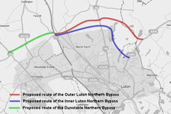 The route of the Dunstable Northern Bypass proposal and route options for the connecting Luton Northern Bypass. | |
| Location | Central Bedfordshire |
|---|---|
| Proposer | Highways Agency |
| Status | Approved |
| Type | Road |
| Cost estimate | £171 million to £217 million |
| Start date | 2014–2015 |
| Completion date | 2016–2017 |
| Geometry | KML |
The A5-M1 Link (Dunstable Northern Bypass), which opened in May 2017, is a two-lane dual carriageway running east from the A5 north of Dunstable to join the M1 at a new Junction 11a south of Chalton.[26] Here, it is intended to join with a proposed Luton Northern Bypass to form a northern bypass for the wider conurbation. The A5-M1 Link aims to alleviate traffic congestion in Houghton Regis and Dunstable, reduce journey times for long-distance traffic travelling through Dunstable and improve the regional economy. Highways England detrunked the A5 through Dunstable, renumbering it A5183, when the A5-M1 Link opened to the public in May 2017.[27] As a direct result of the detrunking, Central Bedfordshire Council introduced a 7.5 tonne weight limit on most roads in Dunstable town centre in 2017 with the aim of easing congestion.[28]
Woodside Link
The 1.8 mi (2.9 km) A5505 Woodside Link connects the industrial areas of Dunstable and Houghton Regis to the new junction 11a of the M1 motorway.[29] This road takes traffic out of the town centres, reduces congestion and improves air quality. Forming part of Central Bedfordshire Council's Dunstable Town Centre Masterplan,[27] the Woodside Link improves job opportunities and quality of life for people living and working in Dunstable and neighbouring towns and villages. It will also provide access to a new development area north of Houghton Regis, where 5,150 new homes are to be built and 30 hectares of employment land are to be developed by 2031.[30] Central Bedfordshire Council is delivered the £38.3m scheme with contributions of £20m from SEMLEP's Local Growth Deal,[31] £5m from the UK government's Local Pinch Point Fund[32] and £1m of developer contributions.
Amenities
Culture
Since opening in April 2007 the 780 seat Grove Theatre has replaced the Queensway Hall as the town's premier arts centre.[33]
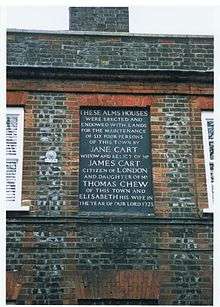
The Little Theatre, home of the Dunstable Rep Theatre Group also hosts dramatic performances throughout the year. The auditorium, once part of the Chews Trust was fully opened in 1964 by Bernard Bresslaw. It sits next to the historic Chews House on High Street South.[34]
The town also has numerous amateur dramatics societies that perform several shows a year. These include 'The Square Drama Circle' and 'Dunstable Amateur Operatics Society'.
Currently a Wetherspoons entitled The Gary Cooper (named after the famous actor who once resided in the town for his education), and a nightclub called BOX3 each occupy a unit in the Grove Park complex. A unit is also currently occupied by Central Bedfordshire College. The other units are occupied by The Performing Arts Depot (PAD), and BBC 3 Counties Radio.
Sport and leisure
Several parks and open spaces are kept by Central Bedfordshire Council along with Dunstable Leisure Centre. The centre was closed on June 4, 2017 to undergo a £20.1 million redevelopment incorporating a brand new town library. 'The Dunstable Centre',[35] which opened in June 2019 (albeit without its swimming pool)[36] includes state-of-the-art leisure facilities, gym, swimming pools and a flexible community space for other public and community services, such as such as the Citizens Advice and adult day care / disabled sports.[37] Stevenage Leisure Limited will manage and operate the leisure centre on behalf on Central Bedfordshire Council.[35]
It neighbours the Grove Theatre[38] (also managed by SLL), a modern 32-lane ten-pin bowling centre, and the main campus of Central Bedfordshire College.
The town is home to two senior football clubs, Dunstable Town F.C. and AFC Dunstable who both play at the Creasey Park Stadium. Dunstable Town F.C. play in the Southern League Premier and AFC Dunstable play in the Spartan South Mildlands League. Dunstable Town famously recruited George Best to ply his trade in the town and defeated Manchester United 3–2 in the process.
A Rugby Union team that plays in RFU Midlands 2 (level 6) called Dunstablians play their matches in nearby Houghton Regis at Bidwell Hill.
Lancot Meadow (51.8853°N 0.5434°W) is a small nature reserve managed by the local Wildlife Trust.[39]
Dunstable Downs Golf Club, founded in 1906 and designed by James Braid, is on the top of the Downs.
Landmarks
Within the town centre is the Grove Theatre, Priory House Heritage Centre and the Priory Church where Henry VIII formalised his divorce from Catherine of Aragon. At the heart of the town sits the Quadrant Shopping Centre, while across High Street North a secondary shopping community named the Eleanor's Cross Shopping Precinct hosts a modern statue commemorating the original cross. Nearby Luton has the Waulud's Bank prehistoric henge and Luton Museum & Art Gallery.
Dunstable Downs, a chalky escarpment outside the town, is a popular site for kite flying, paragliding and hang gliding, while the London Gliding Club provides a base for conventional gliding and other air activities at the bottom of the Downs. Further into the countryside are the open-range Whipsnade Zoo, a garden laid out in the form of a cathedral at Whipsnade Tree Cathedral and the Totternhoe Knolls motte-and-bailey castle.
The Icknield Way Path passes through the town on its 110-mile journey from Ivinghoe Beacon in Buckinghamshire to Knettishall Heath in Suffolk. The Icknield Way Trail, a multi-user route for walkers, horse riders and off-road cyclists also passes through the town. The route of these now leisure routes now go to the west and north of the main conurbation rather than following the road which still bears its name.
Education
Secondary schools in the town include:
- All Saints Academy, Dunstable, formerly Northfields Technology College
- Queensbury Academy, formerly Queensbury Upper School
- Manshead CE Academy, formerly Manshead Upper School
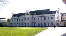
The Priory Academy is a combined Middle and Upper School serving children from the ages of 9 to 16.[40] The former Dunstable Grammar School (later Ashton Middle School) closed in 2016, and its historic buildings have been converted to private residences.
All secondary schools apart from the Priory Academy the town have attached sixth forms.
The Chiltern School and Weatherfield Academy are coeducational special schools in Dunstable. These schools educate pupils from the wider Central Bedfordshire area.
Central Bedfordshire College is a further education site which serves students from Dunstable and the surrounding rural area.
Notable people
- Enosh Pitigala, brother to famous ex local club owner
- Mick Abrahams, founder member of Jethro Tull
- Thomas Aynscombe, (died 1740), son of Elizabeth (died 1711), daughter and co-heiress of Thomas Chew, Dunstable haberdasher
- Nigel Benson, author and illustrator
- Spike Breakwell, comedian
- Clark Brothers, African-American tap dancers who settled in Dunstable after World War II
- Paul Clayton, footballer
- Gary Cooper, Hollywood film actor, went to Dunstable Grammar School from 1910 to 1913[41]
- Kerry Dixon, footballer
- John Dunstaple (or Dunstable), 15th-century composer who was probably born in the town
- Chris Gauthier, actor, grew up here before moving to Canada when he was 5.
- Don Gilet, actor, best known for playing Lucas in EastEnders
- Geoffrey de Gorham, born circa 1100 in Maine, France, became master of a school in Dunstable and later Abbot of St Albans[42]
- Damon Gough, musician known as Badly Drawn Boy
- Nikki Iles, musician
- Rob Keogh, cricketer
- Michael Kilby, Conservative politician
- Rhodri Marsden, musician and writer
- Kevin McCloud, designer, writer and television presenter. Attended Dunstable Grammar School and Manshead Upper School
- Alfred Morcom, cricketer and medical doctor
- Joe Church, Graham Souness lookalike
- Khawaja Nazimuddin, former prime minister of Pakistan
- Alexander Neckam, scientist and teacher
- Bernard O'Mahoney, crime author (was born there in 1960 but moved to Wolverhampton as a child)[43]
- Elkanah Settle, poet and playwright
- Faye Tozer, member of the pop group Steps
Twin towns
Dunstable is twinned with:[44]


Dunstable is also unofficially twinned with Dunstable, MA.
Local destinations
References
- 2001 UK census
- "Town population 2011". Neighbourhood Statistics. Office for National Statistics. Retrieved 7 November 2016.
- Rivet, A. L. F.; Smith, C. (1979), The Place Names of Roman Britain, Batsford, p. 349
- Adrian Room, ed. (1995), Brewer's Dictionary of Phrase and Fable (1st ed.), ISBN 0-304-34869-4
- Sunday Times Travel, 6 January 2008, p. 46
- Genuki entry for Dunstable, Accessed 26_12_09
- May, Francis (20 June 1973). "Nearby Dunstable Mass. Observes 300th Anniversary". Nashua Telegraph. p. 30. Retrieved 18 May 2015 – via Newspapers.com.

- British History Online and William Page (editor), “Parishes,” 29 August 2008
- 'Parishes: Dunstable', A History of the County of Bedford: Volume 3 (1912), pp. 349–368
- British History on line – Dunstable Retrieved, 30 June 2009
- Evans V.; Schneider J. (2002), Dunstable down the ages: an outline history from prehistoric to modern times, Dunstable: Book Castle
- Valente, C. (1998). "The Deposition and Abdication of Edward II". The English Historical Review. 113 (453): 852–881. doi:10.1093/ehr/CXIII.453.852. OCLC 2207424.CS1 maint: ref=harv (link)
- Focus On: Dunstable, 1966, Anglia Television, Anglia Television programme looking at life in the Bedfordshire town of Dunstable.
- cottagegardenflowershop.co.uk, History of the Cottage Garden Flower Shop.
- The District of South Bedfordshire (Electoral Changes) Order 2001 Archived 15 June 2009 at the Wayback Machine.
- Dunstable Town Council, Meet The Councillors Archived 24 November 2007 at the Wayback Machine.
- Walden, pp. 5–9
- Walden, pp. 101, 112, 172, 190–191, 194, 199, 226.
- Walden, pp. 266–268, 275, 282.
- Walden, pp. 6, 136, 145–146.
- Walden, pp. 91, 203, 205.
- Walden, pp. 240, 241, 263–264.
- "www.parliament.uk Home page".
- "Andrew Selous MP, South West Bedfordshire - TheyWorkForYou".
- Guides to Collections: British Railways Board Archived 29 September 2007 at the Wayback Machine at the Bedfordshire and Luton Archives and Records Service.
- "A5-M1 Link (Dunstable Northern Bypass)". Archived from the original on 4 November 2014. Retrieved 25 November 2014.
- "Dunstable Town Centre Masterplan". Retrieved 25 November 2014.
- Council, Central Bedfordshire. "Transport strategy". www.centralbedfordshire.gov.uk. Retrieved 22 December 2019.
- "Woodside Link road". Retrieved 25 November 2014.
- "Houghton Regis North Site 1". Retrieved 25 November 2014.
- "SEMLEP awarded £64.6 million Local Growth Deal". Retrieved 25 November 2014.
- "Successful schemes to be funded in Tranche 2 of the Local Pinch Point Fund" (PDF). Retrieved 25 November 2014.
- "History". Grove Theatre. Retrieved 16 July 2019.
- "Little Theatre". Retrieved 26 March 2009.
- "The Dunstable Centre". www.sll.co.uk. Retrieved 9 January 2019.
- "£20m leisure centre reopens without a pool". 3 June 2019. Retrieved 18 November 2019.
- Council, Central Bedfordshire. "Dunstable Leisure Centre redevelopment". www.centralbedfordshire.gov.uk. Retrieved 9 January 2019.
- "Grove Theatre". www.grovetheatre.co.uk. Retrieved 9 January 2019.
- Wildlife Trust, Lancot Meadow Archived 3 March 2016 at the Wayback Machine
- "Priory Academy". Central Bedfordshire.
- Benson, Nigel (1986). Dunstable in Detail. Dunstable: The Book Castle. pp. 191–195. ISBN 978-0-9509773-2-4.
- ODNB Geoffrey de Gorham, Accessed 8 August 2011
- "Archived copy". Archived from the original on 29 October 2010. Retrieved 11 September 2010.CS1 maint: archived copy as title (link)
- "Dunstable Twinning - Dunstable Town Council".
- "British towns twinned with French towns". Archant Community Media Ltd. Archived from the original on 5 July 2013. Retrieved 11 July 2013.
Bibliography
- Prehistory: Matthews, C. L. (1989). (revised by) Schneider, J (ed.). Ancient Dunstable (2nd ed.). Manshead Archaeological Society. ISBN 0-9515160-0-0.
- Historical town-centre locations: Benson, Nigel (1986). Dunstable in Detail: An Illustrated Guide to the Town of Dunstable. Dunstable: Book Castle. ISBN 0-9509773-2-2.
- Street names: Walden, R. (1999). Streets Ahead: An Illustrated Guide to the Street Names of Dunstable. Dunstable: Book Castle. ISBN 1-87119-959-X.
- Second World War: Yates J. & King S. (2006). Dunstable and District at War from Eyewitness Accounts. Dunstable: Book Castle. ISBN 1-903747-79-1.
External links
| Wikivoyage has a travel guide for Dunstable. |
| Wikimedia Commons has media related to Dunstable. |
- Dunstable Town Council
- Focus On: Dunstable, 1966 Anglia Television programme looking at life in Dunstable, East Anglian Film Archive.
