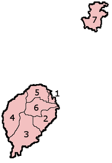
Districts of São Tomé and Príncipe
São Tomé and Príncipe is divided into seven administrative districts since 1980.[1] Six are located on the main island of São Tomé while one (Pagué) covers the smaller island of Príncipe. Since 1995, the Pagué District has been replaced by the Autonomous Region of Príncipe.[2]
| Map Key | District | Capital | Area (km2) [3] |
Population (2012 census)[4] |
Population 2018 estimate[5] |
|---|---|---|---|---|---|
| 1 | Água Grande | São Tomé | 16.5 | 69,772 | 77,700 |
| 2 | Cantagalo | Santana | 119.0 | 17,169 | 19,400 |
| 3 | Caué | São João dos Angolares | 267.0 | 6,062 | 7,200 |
| 4 | Lembá | Neves | 229.5 | 14,676 | 16,300 |
| 5 | Lobata | Guadalupe | 105.0 | 19,414 | 22,000 |
| 6 | Mé-Zóchi | Trindade | 122.0 | 44,763 | 50,800 |
| 7 | Autonomous Region of Príncipe (Pagué) | Santo António | 142.0 | 7,344 | 8,420 |
 |
|---|
| This article is part of a series on the politics and government of São Tomé and Príncipe |
|
|
Legislature
|
|
Judiciary
|
|
Administrative divisions |
|
|
References
- República Democrática de São Tomé e Príncipe, Ministry of Foreign Affairs
- Nunes Silva, Carlos (2016). "São Tomé and Príncipe". Governing Urban Africa. Springer Nature. pp. 35–39. ISBN 9781349951093 – via Google Books.
- Sao Tome and Principe, citypopulation.de
- Projecção a nível distrital 2012 - 2020, Instituto Nacional de Estatística
- Instituto Nacional de Estadística de São Tomé e Príncipe, as at 13 May 2018.
This article is issued from Wikipedia. The text is licensed under Creative Commons - Attribution - Sharealike. Additional terms may apply for the media files.
