Deer Creek Township, Carroll County, Indiana
Deer Creek Township is one of fourteen townships in Carroll County, Indiana. As of the 2010 census, its population was 4,571 and it contained 1,970 housing units.[3]
Deer Creek Township | |
|---|---|
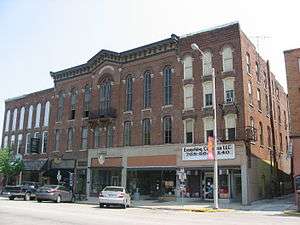 The Delphi City Hall, a historic place in the township | |
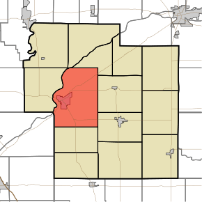 Location of Deer Creek Township in Carroll County | |
| Coordinates: 40°35′15″N 86°37′59″W | |
| Country | United States |
| State | Indiana |
| County | Carroll |
| Government | |
| • Type | Indiana township |
| Area | |
| • Total | 43.94 sq mi (113.8 km2) |
| • Land | 43.7 sq mi (113 km2) |
| • Water | 0.24 sq mi (0.6 km2) |
| Elevation | 627 ft (191 m) |
| Population (2010) | |
| • Total | 4,571 |
| • Density | 104.6/sq mi (40.4/km2) |
| FIPS code | 18-17236[2] |
| GNIS feature ID | 453257 |
History
Deer Creek Township was organized in 1828.[4]
The Baum-Shaeffer Farm, Carrollton Bridge, Deer Creek Valley Rural Historic District, Delphi Lime Kilns, Lock No. 33 Lock Keeper's House, and Wabash and Erie Canal Lock No. 33, Fred and Minnie Raber Farm, Sunset Point, and Wilson Bridge are listed on the National Register of Historic Places.[5]
Geography
According to the 2010 census, the township has a total area of 43.94 square miles (113.8 km2), of which 43.7 square miles (113 km2) (or 99.45%) is land and 0.24 square miles (0.62 km2) (or 0.55%) is water.[3]
Cities and towns
- Delphi (the county seat)
Unincorporated towns
- Harley (extinct)
Adjacent townships
- Adams (north)
- Rock Creek (northeast)
- Jackson (east)
- Monroe (southeast)
- Madison (south)
- Washington Township, Tippecanoe County (southwest)
- Tippecanoe (west)
- Tippecanoe Township, Tippecanoe County (west)
Cemeteries
The township contains eight cemeteries: Bostetter, Delphi, Mears, Robinson, Saint Josephs, Sharp Point, Whistler and Wingard.
References
- "Deer Creek Township, Carroll County, Indiana". Geographic Names Information System. United States Geological Survey. Retrieved 2009-09-24.
- United States Census Bureau cartographic boundary files
- "US Board on Geographic Names". United States Geological Survey. 2007-10-25. Retrieved 2008-01-31.
- "U.S. Census website". United States Census Bureau. Retrieved 2008-01-31.
- "Population, Housing Units, Area, and Density: 2010 - County -- County Subdivision and Place -- 2010 Census Summary File 1". United States Census. Archived from the original on 2020-02-12. Retrieved 2013-05-10.
- Odell, John Curtis (1916). History of Carroll County, Indiana: Its People, Industries and Institutions. B.F. Bowen. p. 82.
- "National Register Information System". National Register of Historic Places. National Park Service. July 9, 2010.
External links
Municipalities and communities of Carroll County, Indiana, United States | ||
|---|---|---|
| City | Map of Indiana highlighting Carroll County | |
| Towns | ||
| Townships | ||
| Unincorporated communities |
| |