Carrollton Township, Carroll County, Indiana
Carrollton Township is one of fourteen townships in Carroll County, Indiana. As of the 2010 census, its population was 598 and it contained 244 housing units.[3]
Carrollton Township | |
|---|---|
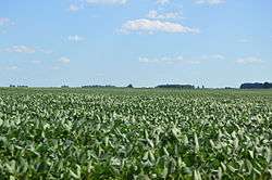
 Cornfield southeast of Sharon | |
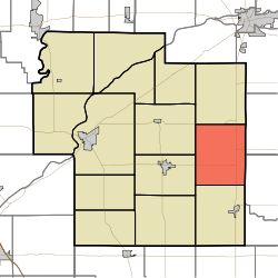
 Location of Carrollton Township in Carroll County | |
| Coordinates: 40°33′36″N 86°25′12″W | |
| Country | United States |
| State | Indiana |
| County | Carroll |
| Government | |
| • Type | Indiana township |
| Area | |
| • Total | 29.59 sq mi (76.6 km2) |
| • Land | 29.58 sq mi (76.6 km2) |
| • Water | 0.01 sq mi (0.03 km2) |
| Elevation | 725 ft (221 m) |
| Population (2010) | |
| • Total | 598 |
| • Density | 20.2/sq mi (7.8/km2) |
| FIPS code | 18-10540[2] |
| GNIS feature ID | 453160 |
History
Carrollton Township was organized in 1835.[4]
Geography
According to the 2010 census, the township has a total area of 29.59 square miles (76.6 km2), of which 29.58 square miles (76.6 km2) (or 99.97%) is land and 0.01 square miles (0.026 km2) (or 0.03%) is water.[3]
Adjacent townships
- Washington Township (north)
- Deer Creek Township, Cass County (northeast)
- Ervin Township, Howard County (east)
- Burlington Township (south)
- Jackson Township (west)
- Monroe Township (west)
Major highways
gollark: For example: apparently climate change is causing more/worse hurricanes or something. But if we heat the Earth by something like ~~10~~ 30 degrees, there will be hypercanes instead.
gollark: If the Earth is heated enough, the effects of this will counter the effects of it only being heated slightly.
gollark: Idea: climate change acceleratonism.
gollark: I have an anarchy one which is doing great if you ignore the total lack of law enforcement or something.
gollark: My main nation has great civil rights and political freedom but also somehow 90% taxes.
References
- "Carrollton Township, Carroll County, Indiana". Geographic Names Information System. United States Geological Survey. Retrieved 2009-09-24.
- United States Census Bureau cartographic boundary files
- "US Board on Geographic Names". United States Geological Survey. 2007-10-25. Retrieved 2008-01-31.
- "U.S. Census website". United States Census Bureau. Retrieved 2008-01-31.
- "Population, Housing Units, Area, and Density: 2010 - County -- County Subdivision and Place -- 2010 Census Summary File 1". United States Census. Archived from the original on 2020-02-12. Retrieved 2013-05-10.
- Odell, John Curtis (1916). History of Carroll County, Indiana: Its People, Industries and Institutions. B.F. Bowen. p. 81.
This article is issued from Wikipedia. The text is licensed under Creative Commons - Attribution - Sharealike. Additional terms may apply for the media files.