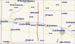
Indiana State Road 341
State Road 341 in the U.S. state of Indiana is a north–south state highway in Fountain County in the west-central part of the state.
| ||||
|---|---|---|---|---|
 | ||||
| Route information | ||||
| Maintained by INDOT | ||||
| Length | 22.744 mi[1] (36.603 km) | |||
| Major junctions | ||||
| South end | ||||
| North end | ||||
| Location | ||||
| Counties | Fountain | |||
| Highway system | ||||
| ||||
Route description
The road starts near the south edge of the county at State Road 234 just over a mile south of Wallace. It passes north through the town of Hillsboro, where it is concurrent with Main Street and U.S. Route 136, then crosses Interstate 74 just north of Hillsboro and continues through the towns of Mellott and Newtown, and terminates at State Road 28 east of Attica.
Major intersections
The entire route is in Fountain County.
| Location | mi[1] | km | Destinations | Notes | |
|---|---|---|---|---|---|
| Jackson Township | 0.000 | 0.000 | Southern terminus of SR 341 | ||
| 5.313 | 8.550 | Southern end of SR 32 concurrency | |||
| 5.413 | 8.711 | Northern end of SR 32 concurrency | |||
| Hillsboro | 10.175 | 16.375 | Western end of US 136 concurrency | ||
| 10.789 | 17.363 | Eastern end of US 136 concurrency | |||
| Newtown | 17.503 | 28.168 | |||
| Davis Township | 22.744 | 36.603 | Northern terminus of SR 341 | ||
1.000 mi = 1.609 km; 1.000 km = 0.621 mi
| |||||
gollark: <:Transistor:694654534634569809> > <:toob:726964635206680606>
gollark: It was deliberately picked for this month.
gollark: It's been like that since the start of October.
gollark: > how would they use your minecraft game to data mineChat logs?
gollark: <@225689477836701696> https://what-if.xkcd.com/13/
References
- Indiana Department of Transportation (July 2016). Reference Post Book (PDF). Indianapolis: Indiana Department of Transportation. Retrieved April 13, 2017.
External links
This article is issued from Wikipedia. The text is licensed under Creative Commons - Attribution - Sharealike. Additional terms may apply for the media files.
