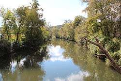
Coosawattee River
The Coosawattee River is a 49.3-mile-long (79.3 km)[2] river located in the northwestern Georgia, United States.[1]
| Coosawattee River | |
|---|---|
 | |
| Location | |
| Country | United States |
| State | Georgia |
| County | Gilmer, Gordon, & Murray |
| Physical characteristics | |
| Source | confluence of the Ellijay and Cartecay rivers |
| • location | Ellajay |
| • coordinates | 34.6914744°N 84.4835388°W[1] |
| • elevation | 575 ft (175 m)[2] |
| Mouth | Oostanaula River |
• location | at Carters Lake |
• coordinates | 34.6050863°N 84.6332661°W[1] |
• elevation | 1,073 ft (327 m)[1] |
| Length | 49.3 mi (79.3 km)[2] |
| Basin features | |
| Tributaries | |
| • left | Coley Creek, Harris Creek, Camp Branch, Lewis Branch, Camp Branch, Talking Rock Creek, Duke Creek, Dry Creek, Salacoa Creek, and Crane Eater Creek |
| • right | Mountaintown Creek, Tails Creek, Goble Branch, Woodring Branch, Fisher Creek, Willbanks Branch, Mineral Springs Branch, Rock Springs Branch, Sugar Branch, Noblet Creek, Dry Creek, and Vanns Creek |
Description
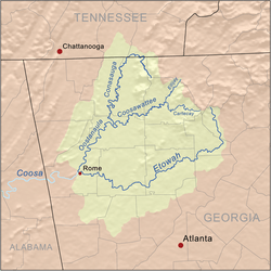
The river begins at the confluence of the Ellijay and Cartecay rivers in the city of Ellijay in central Gilmer County. The river flows west through the foothills in the North Georgia mountains region and is a tributary of the Oostanaula River (which it turn is a tributary of the Coosa River). Primary tributaries of the Cooswattee River include Mountaintown Creek, Tails Creek, Cole Creek, Goble Branch, Harris Creek, Camp Branch, Lewis Branch, Woodring Branch, Fisher Creek, Talking Rock Creek, Willbanks Branch, Mineral Springs Branch, Rock Springs Branch, Sugar Branch, Duke Creek, Noblet Creek, Dry Creek, Salacoa Creek, Vanns Creek, and Crane Eater Creek
In Murray County, the river is impounded by Carters Dam, forming Carters Lake (which is located mostly in Gilmer County). Completed in 1977, Carters Dam is the tallest earthen dam east of the Mississippi River.[3] The Coosawattee river leaves the dam flowing west (directly into the Reregulation Reservoir) and briefly serves as the Murray-Gordon County line before entering Gordon County. Near New Echota, the Coosawattee meets the Conasauga River, forming the Oostanaula River, a tributary of the Coosa River.[4]
This area was the center of Cherokee Nation territory in north Georgia and southern Tennessee. In the early 1820s, after having migrated from eastern Tennessee, they made New Echota their capital.
American writer James Dickey used the Coosawattee River as the basis of his fictional "Cahulawassee River" in his debut novel, Deliverance (1970). It was adapted as a 1972 feature film of the same name, directed by John Boorman.
See also
- List of rivers in Georgia (U.S. state)
References
- U.S. Geological Survey Geographic Names Information System: Coosawattee River
- U.S. Geological Survey. National Hydrography Dataset high-resolution flowline data. The National Map Archived 2016-06-30 at the Wayback Machine, accessed April 27, 2011
- "Carters Lake". US Army Corps of Engineers, Mobile District. United States Army Corps of Engineers. Retrieved 15 December 2015.
- Krakow, Kenneth K. (1975). Georgia Place-Names: Their History and Origins (PDF). Macon, Georgia: Winship Press. p. 51. ISBN 0-915430-00-2.
External links
![]()
| Authority control |
|
|---|