Coal Region
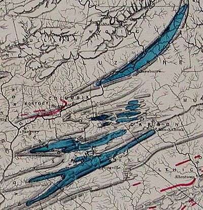
The Coal Region is a historically important coal-mining area in Northeastern Pennsylvania in the central Ridge-and-valley Appalachian Mountains, comprising Lackawanna, Luzerne, Columbia, Carbon, Schuylkill, Northumberland, and the extreme northeast corner of Dauphin counties. Academics have made the distinction between North Anthracite Coal Field and South Anthracite Coal Field,[1] the lower region bearing the further classification Anthracite Uplands[2] in physical geology. The Southern Coal Region can be further broken into the Southeastern and Southwestern Coal Regions, with the divide between the Little Schuylkill and easternmost tributary of the Schuylkill River with the additional divide line from the Lehigh watershed extended through Barnesville the determining basins.


The region's combined population was 898,834 people as of 2015. Many of the place names in the region are from the Delaware Indians (the self-named Lenape peoples) and the powerful Susquehannock nation, an Iroquoian people who dominated the Susquehanna valley in the 16th and 17th century when Dutch, Swedish and French migrants were exploring North America and founding settlements along the Atlantic Seaboard.
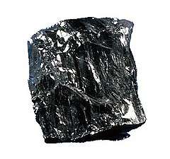
The Coal Region or Pennsylvania Anthracite Region or fields is home to the largest known deposits of anthracite coal found in the Americas, with an estimated reserve of seven billion short tons.[3]
Geography

The region lies north of the Lehigh Valley and Berks County Regions, south of the Endless Mountains, west of the Pocono Mountains, and east of the Susquehanna Valley. The region lies at the northern edge of the Ridge-and-Valley Appalachians, and draws its name from the vast deposits of anthracite coal that can be found under several of the valleys in the region. The Wyoming Valley is the most densely populated of these valleys, and contains the cities of Wilkes-Barre, Greater Pittston, and Scranton. Hazleton and Pottsville are two of the larger cities in the southern portion of the region. The Lehigh and Schuylkill Rivers both originate within the region, while the much larger Susquehanna River skirts the northern edge.

| County | 2015 Population | 2010 Population | Area |
|---|---|---|---|
| Carbon County | 63,960 | 65,249 | 387 sq mi (1,002 km2) |
| Columbia County | 66,672 | 67,295 | 490 sq mi (1,269 km2) |
| Lackawanna County | 211,917 | 214,437 | 465 sq mi (1,204 km2) |
| Luzerne County | 318,449 | 320,918 | 906 sq mi (2,350 km2) |
| Northumberland County | 93,246 | 94,528 | 478 sq mi (1,238 km2) |
| Schuylkill County | 144,590 | 148,289 | 783 sq mi (2,028 km2) |
| Total | 898,834 | 910,716 | 3,509 sq mi (9,088 km2) |
History
.jpg)
.jpg)
The population of the Amerindian tribesmen of the Susquehannock nation was reduced 90 percent[4] in three years of a plague of diseases and possibly war,[4] opening up the Susquehanna Valley and all of Pennsylvania to settlement as the tribe was all but eliminated. Settlement in the region predates the American Revolution: both Delaware and Susquehannock power had been broken by disease and Indian-on-Indian warfare before the British took over the Dutch and Swedish colonies and settled Pennsylvania.
_by_Lewis_Hine.jpg)
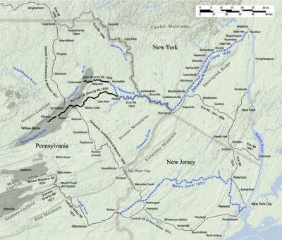
The first discovery of anthracite coal in the region occurred in 1762, and the first mine was established in 1775 near Pittston.[5] In 1791, anthracite was discovered by a hunter atop Pisgah Ridge, and by 1792 the Lehigh Coal Mining Company began producing and shipping coal to Philadelphia via Mauch Chunk from the Southern Anthracite Field and Summit Hill, built atop the line between Schuylkill County and what would be renamed Carbon County. By 1818, customers fed up with the inconsistent mismanagement leased the Lehigh Coal Mining Company and founded the Lehigh Navigation Company: construction soon began for navigation; the locks and dams on the Lehigh River rapids stretches, later known as the Lehigh Canal (finished in 1820).
In 1822, the two companies merged as the Lehigh Coal & Navigation Company (LC&N), and by 1824 the company was shipping large volumes of coal down the Lehigh and Delaware Canals. Meanwhile, three brothers had similar ideas from near the turn of the century, and about the same time began mining coal in Carbondale, 15 miles (24.1 km) northeast of Scranton, but high enough to run a gravity railroad to the Delaware River and feed New York City via the Delaware and Hudson Canal. Pennsylvania began the Delaware Canal to connect the Lehigh Canal to Philadelphia and environs, while funding to build a canal across the Appalachians' Allegheny Mountains to Pittsburgh. In 1827, LC&N built the second railroad in the country, a gravity railroad from Mauch Chunk Switchback Railway, running Summit Hill to Mauch Chunk.
Population rapidly grew in the period following the American Civil War, with the expansion of the mining and railroad industries. English, Welsh, Irish and German immigrants formed a large portion of this increase, followed by Polish, Slovak, Ruthenian, Ukrainian, Hungarian, Italian, Russian, Jewish,[6] and Lithuanian immigrants. The influence of these immigrant populations is still strongly felt in the region, with various towns possessing pronounced ethnic characters and cuisine.
The anthracite mining industry loomed over the region until its decline in the 1950s. Strip mines and fires, most notably in Centralia, remain visible. Several violent incidences in the history of the U.S. labor movement occurred within the coal region as this was the location of the Lattimer Massacre and the home of the Molly Maguires.[7]
The Knox Mine Disaster in 1959 served as the death knell for deep mining which faded away in the mid 1960s;[8] almost all current anthracite mining is done via strip mining. Tours of underground mines can be taken in Ashland, Scranton, and Lansford, each of them also having museums dedicated to the mining industry. Also evident are patch towns, small villages affiliated with a particular mine. These towns were owned by the mining company. Though no longer company owned, many hamlets survive; one of them, the Eckley Miners' Village, is a museum and preserved historical town owned and administered by the Pennsylvania Historical and Museum Commission, which seeks to restore patch towns to their original state.
People
- Notable people from the Coal Region
- Nick Adams, actor
- Joe Amato, five-time NHRA Top Fuel Champion Drag Racer
- Gary Becker, Nobel Prize–winning economist (1992).
- Joe Biden, U.S. Vice President
- David Bohm, quantum physicist
- George Bretz (1842-1895), photographed the Coal Region
- Les Brown, jazz musician
- Ben Burnley, lead singer of rock band Breaking Benjamin
- P. J. Carlesimo, professional basketball coach, San Antonio Spurs
- Robert P. Casey, former Governor of Pennsylvania
- Bob Casey, Jr., U.S. Senator
- George Catlin, artist
- Jimmy Cefalo, professional football player, Miami Dolphins
- Stan Coveleski, Major League Baseball Hall of Fame member
- Anthony P. Damato, United States Marine, Medal of Honor recipient
- Jack Dolbin, professional football player, Denver Broncos
- Jimmy Dorsey, jazz clarinetist, saxophonist, big band leader
- Tommy Dorsey, jazz trombonist, big band leader
- Ellen Albertini Dow, actress, The Wedding Singer's Rapping Granny
- Ham Fisher, cartoonist
- Daniel J. Flood, U.S. Congressman
- Alexander Joseph Foley, United States Marine, Medal of Honor recipient
- Howard Gardner, scientist, author
- James M. Gavin, Lieutenant General, United States Army
- Jimmy Gownley, author, illustrator, cartoonist
- Henry Hynoski, professional football player for the New York Giants
- Jane Jacobs, sociologist, author
- Russell Johnson, actor
- John E. Jones III, judge, born in Pottsville
- George Joulwan, Supreme Allied Commander, Europe from 1993 to 1997.
- Paul E. Kanjorski, member of Congress
- Jean Kerr, author
- Eddie Korbich, actor
- Matthew Lesko, infomercial personality
- Edward B. Lewis, Nobel Prize-winning scientist
- Joe Maddon, manager of the Chicago Cubs
- Joseph L. Mankiewicz, film director, producer, and screenwriter
- Richard Marcinko, Navy Seal, author
- Christy Mathewson, professional baseball player
- Mary McDonnell, actress
- Gerry McNamara, college basketball player, Syracuse University
- Jason Miller, Pulitzer Prize-winning playwright, actor
- Mike Munchak, professional football coach and former professional football player
- Jozef Murgaš, radio pioneer
- Amedeo Obici, founder of the Planters Peanuts Company
- John O'Hara, author
- Jim O'Neill (baseball), former baseball player
- Steve O'Neill, former baseball player
- Jack Palance, actor
- William Daniel Phillips, Nobel Prize-winning scientist
- Joe Pisarcik, former NFL quarterback
- Darryl Ponicsan, author, screenwriter
- Robert Reich, former U.S. Secretary of Labor
- Paul W. Richards, former astronaut
- Conrad Richter, author
- Hugh Rodham, father of Hillary Rodham Clinton
- Tim Ruddy, center for the Miami Dolphins, 1994-2003
- Victor Schertzinger, composer, film director, film producer and screenwriter
- William Scranton, former Governor of Pennsylvania and 1964 U.S. Presidential candidate
- William Scranton, III, former Lieutenant Governor of Pennsylvania
- B. F. Skinner, psychologist, radical behaviorist, Harvard professor, and author
- Jimmy Spencer, former NASCAR driver and current TV analyst
- Bob Sura, Houston Rockets NBA basketball player
- Charley Trippi, played for Pittston Patriots, NFL Hall of Fame
- John Anthony Walker, spy for the Soviet Union
- Ed Walsh, former professional baseball player, Chicago White Sox
See also
- Eckley Miners' Village
- Franklin B. Gowen
- Hazleton, Pennsylvania
- Mahanoy City, Pennsylvania
- Mahantongo
- Major coal producing regions
- Schuylkill Canal
- Shenandoah, Pennsylvania
References
- Healey, Richard (2005) "The Breakers of the Northern Anthracite Coalfield of Pennsylvania", 'Vol. 1, Major breakers prior to 1902'. Dept of Geography, University of Portsmouth, Portsmouth. quote="Northern Anthracite Coalfield of Pennsylvania" (implying there is a Southern Anthracite Coalfield of Pennsylvania)
- Sevon, W. D., compiler, 2000, "Physiographic provinces of Pennsylvania", Pennsylvania Geological Survey of the Pennsylvania Department of Conservation and Natural Resources, Pennsylvania Geological Survey, 4th ser., Map 13, scale 1:2,000,000.
- PA DEP Website
- see facts cited and cites of American Heritage book of Indians (1961) in articles: Iroquois, Susquehannock
- http://www.msha.gov/district/dist_01/history/history.htm%7Cwork=The Archived 2012-03-24 at the Wayback Machine U.S. Department of Labor|publisher=Mine Safety and Health Administration
- Many descents of openly-Jewish immigrants were born in, e.g., Luzerne County alone, per JewishGen and Ancestry.com.
- Thomas Keil, Jacqueline M. Keil; 2014. Anthracite's Demise and the Post-Coal Economy of Northeastern Pennsylvania. Lehigh University Press. pp. 15–. ISBN 978-1-61146-176-3.
- Karen Ahlquist, 2006. Chorus and Community. University of Illinois Press. p. 225. ISBN 978-0-252-07284-0.
External links
- Coal Mine Region - The Carpathian Connection

- Pennsylvania's Northern Coal Field
- A collection of nostalgia and regionalisms from the Anthracite Coal Region of Pennsylvania
- The Anthracite Coal region
- Map of the anthracite coal fields of Pennsylvania
- History of anthracite coal mining
- Abandoned Anthracite Mines in PA
- Brief history of the Molly Maguires
- "A Jewel In the Crown of Old King Coal Eckley Miners' Village" by Tony Wesolowsky, Pennsylvania Heritage Magazine, Volume XXII, Number 1 - Winter 1996
- A website with extensive detail on and a virtual tour of Eckley
